This item has been sold, but you can get on the Waitlist to be notified if another example becomes available, or purchase a digital scan.
1895 Hansen Map of the French Congo (Gabon) with important Mansucript Annotations
CongoFrancais-hansen-1895$3,000.00

Title
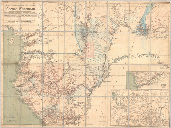
Service Géographique des Colonies Congo Français.
1895 (dated) 38 x 50 in (96.52 x 127 cm) 1 : 1500000
1895 (dated) 38 x 50 in (96.52 x 127 cm) 1 : 1500000
Description
An extremely rare large format map of the French Congo (Congo Français) issued by Jules-André-Arthur Hansen in 1895 with important manuscript annotations relating to the 1899 divvying of the colony into land grants and concessions. This map expresses French claims to lands to the north of the Belgian controlled Congo Free State and Congo River to the border with German occupied Cameroon. This roughly includes the modern day nations of Gabon, Equatorial Guinea, Republic of the Congo, and the Central African Republic. Adjacent parts of Cameroon, the Congo Free State, and the Gulf of Biafra are also included. Based upon explorations conducted between 1867 and 1895 by over 100 different explorers, this was the finest map of the French west Africa yet published.
Most exciting are the copious manuscript annotations evident throughout the map that reflect planning associated with the Concessions Decree of 1899. In 1899 the French Colonial Ministry parceled out the greater part of the French Congo into 30 year grants among some 40 concession companies in imitation of a similar policy adopted earlier by the Congo Free State. The hope was that private industry, funded by joint stock ventures, would succeed in developing French Africa where direct colonial administration failed. In the present map the concessions have been added, sometimes with corrections, in black ink manuscript. Some of have been highlighted with colored pencil.
Of the 40 concessions shown through manuscript boundary lines only 4 are specifically identified by name. These, the concessions granted to M. Mimerel, Lucian Gazengel, William Guynet, and Gaston Metsayer, are emphasized and and named in an exceptionally fine hand seemingly separate from the cruder work throughout delineating the other concessions. Of these four, two are further emphasized, those of Metsayer and Mimerel. Here, the borders of the grants are carefully delineated, with precise survey lines aligned with latitude lines set exactly 15km apart. Additional precise survey work focuses on the trapezoidal zone of land where the Mimerel and Mestayer concession meet.
The Mimerel and Mestayer concessions, both struggling financially. were consolidated around 1901 as Companie de la Sangha. A second regrouping of the still beleaguered firms followed in 1904, which consolidated these and the additional concessions of Guynet and Gazengel into the Ngoko-Sangha, all under the management of Gaston Mestayer, a somewhat ill omened figure of dubious morals. Given the focus of the manuscript work on these provinces, we can reasonably speculate that this map was used in either the planning stages either the 1901 or 1904 mergers. It is doubtless that, armed with excellent French, and patience to plow through colonial records enshrined in Paris, the exact purpose of these clearly important manuscript annotations, could be deduced.
This map was prepared by J. Hansen based upon records of numerous individual merchants and explorers, many of whom are identified directly just below the title. It was published in 1895 with Augustin Challamel of 17 Rue Jacob, Paris. It was printed by Monroco of Paris. This map is extremely rare. WorldCat identifies only 2 other examples, one at the Archives Nationales d'Outre-Mer (FR ANOM 43 PA/1/3) in Paris and another in the Universite Bordeaux Montaigne Bibliothèque de Géographie (10-03-15-04). Nonetheless, given the similarities between the two catalog entities, we believe these are likely to represent duplicate entries for the same item.
Cartographer
Jules André Hansen (February 8, 1849 – March 27, 1931) was a French cartographer active in Paris during the later part of the 19th century. Hansen's work particularly focused on consolidating exploratory and merchant reports of travelers in Africa into practical maps of various parts of French controlled Africa. More by this mapmaker...
Condition
Very good. Manuscript annotations throughout. Dissected and mounted on linen in 32 panels. Comes with custom clamshell box.
References
OCLC: 863815889. WorldCat lists two examples, one at the Archives Nationales d'Outre-Mer (FR ANOM 43 PA/1/3) in Paris and another in the Universite Bordeaux Montaigne Bibliothèque de Géographie (10-03-15-04). Nonetheless, given the similarities between the two catalog entities, we believe it these are likely to represent duplicate entries for the same item.