This copy is copyright protected.
Copyright © 2025 Geographicus Rare Antique Maps
Digital Image: 1852 Roderick Nevers Map of Connecticut and Long Island
Connecticut-nevers-1852_d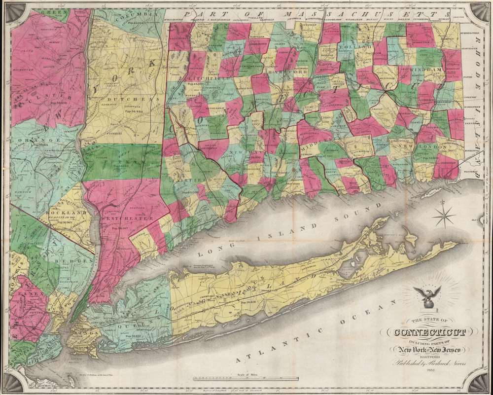

FOR THE ORIGINAL ANTIQUE MAP, WITH HISTORICAL ANALYSIS, CLICK HERE.
Digital Map Information
Geographicus maintains an archive of high-resolution rare map scans. We scan our maps at 300 DPI or higher, with newer images being 600 DPI, (either TIFF or JPEG, depending on when the scan was done) which is most cases in suitable for enlargement and printing.
Delivery
Once you purchase our digital scan service, you will receive a download link via email - usually within seconds. Digital orders are delivered as ZIP files, an industry standard file compression protocol that any computer should be able to unpack. Some of our files are very large, and can take some time to download. Most files are saved into your computer's 'Downloads' folder. All delivery is electronic. No physical product is shipped.
Credit and Scope of Use
You can use your digial image any way you want! Our digital images are unrestricted by copyright and can be used, modified, and published freely. The textual description that accompanies the original antique map is not included in the sale of digital images and remains protected by copyright. That said, we put significant care and effort into scanning and editing these maps, and we’d appreciate a credit when possible. Should you wish to credit us, please use the following credit line:
Courtesy of Geographicus Rare Antique Maps (http://www.geographicus.com).
How Large Can I Print?
In general, at 300 DPI, you should at least be able to double the size of the actual image, more so with our 600 DPI images. So, if the original was 10 x 12 inches, you can print at 20 x 24 inches, without quality loss. If your display requirements can accommodate some loss in image quality, you can make it even larger. That being said, no quality of scan will allow you to blow up at 10 x 12 inch map to wall size without significant quality loss. For more information, it is best consult a printer or reprographics specialist.
Refunds
If the high resolution image you ordered is unavailable, we will fully refund your purchase. Otherwise, digital images scans are a service, not a tangible product, and cannot be returned or refunded once the download link is used.
Roderick Nevers (April 30, 1808 - August 13, 1888) was an American printer and publisher. Born in Springfield, Massachusetts, Nevers worked in Hartford in the printing and publishing world from at least 1841 until 1887. He was a partner in the firm Case, Nevers, and Company, with Lucius Case and Alfred R. Skinner from at least 1841 until April 10, 1843. He was a partner in the firm Case and Nevers until 1849, when he opened his own firm, which he operated until 1887. Per his obituary, 'For nearly fifty years he was engaged in the business of engraving and plat printing, and a generation ago had no superior in that profession. He was a man of genial manners, and was universally esteemed. His death was in part the result of injuries received last winter by falling on an icy sidewalk.' He married Melissa Sykes Nevers (1812 - 1897) on October 6, 1835, with whom he had four children. More by this mapmaker...
Copyright © 2025 Geographicus Rare Antique Maps | Geographicus Rare Antique Maps
This copy is copyright protected.
Copyright © 2025 Geographicus Rare Antique Maps