This item has been sold, but you can get on the Waitlist to be notified if another example becomes available, or purchase a digital scan.
1855 Dufour City Plan or Map of Istanbul, Turkey
Constantinople-dufour-1855$125.00

Title
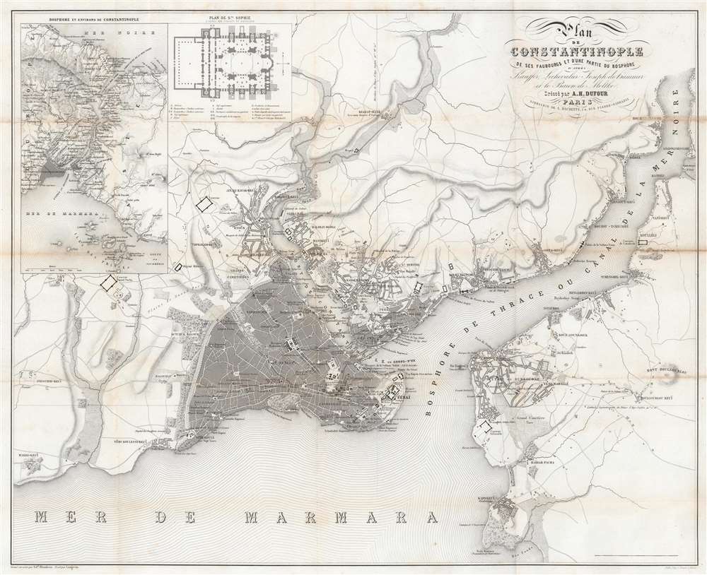
Plan de Constantinople de ses Faubourgs et d'une partie du Bosphore d'après Kauffor, Lechevalier, Joseph de Hammer et le Baron de Moltke.
1855 (undated) 17.75 x 22.25 in (45.085 x 56.515 cm) 1 : 30000
1855 (undated) 17.75 x 22.25 in (45.085 x 56.515 cm) 1 : 30000
Description
This is a c. 1855 Adolphe Dufour city plan or map of Istanbul / Constantinople, Turkey. Published during the Crimean War (1853 - 1856), Dufour provides a detailed look at the Ottoman capital. The Hagia Sophia (labeled here as Ste. Sophie) is illustrated, along with other mosques, including the Suleymaniye Mosque. Many are illustrated iconographically, meaning a cross-section of the building illustrates the floor plan. The Topkapi Palace, also known as the Seraglio, is illustrated in detail. Numerous other locations are identified, including the French and Austrian embassies, the Grand Bazaar, other shops, and cemeteries. An inset situated in the upper left details the Hagia Sophia, alphabetically identifying parts of the iconic building. A second inset illustrates the entire Bosporus along with Istanbul and its environs.
Hostilities erupted in July 1853 when Russia invaded two Ottoman suzerainties known collectively as the Danubian Principalities: Wallachia and Moldavia. The Ottomans immediately responded and fought a defensive campaign that eventually halted the Russian advance at Silistra, which the Russians besieged. Alarmed by the possibility of an Ottoman collapse, the British and French jumped to their aid, sending troops and supplies to Gallipoli. They did not arrive at Silistra until after the Russians had withdrawn.
At this point, public opinion at home, where discontent aroused by the wasted effort and expense of sending armies to the Balkans, exerted an influence on the alliance. This outcry led to the planning and execution of an invasion of the Crimean Peninsula and a siege of the Russian naval port of Sevastopol, their primary naval base in the Black Sea. The siege lasted eleven months. Russia finally sued for peace in March 1856. In the Treaty of Paris that ended the war Russia lost its Black Sea ports, Wallachia and Moldavia gained a modicum of independence, and Christians in the Holy Land were given a degree of equality.
The Crimean War
The Crimean War, with an alliance of the Ottoman Empire, Britain, France, and Sardinia on one side of the conflict and the Russian Empire on the other, lasted from October 1853 until February 1856. The root cause of the war has never been fully understood, but the stated impetus for hostilities was the rights of Christians in the Holy Land, with the Catholics being supported by the French and the Greek Orthodox Church gaining the support of the Russians. Other factors also included the gradual decline of the Ottoman Empire and British and French concerns about Russian gains in the region at the cost of the Ottomans.Hostilities erupted in July 1853 when Russia invaded two Ottoman suzerainties known collectively as the Danubian Principalities: Wallachia and Moldavia. The Ottomans immediately responded and fought a defensive campaign that eventually halted the Russian advance at Silistra, which the Russians besieged. Alarmed by the possibility of an Ottoman collapse, the British and French jumped to their aid, sending troops and supplies to Gallipoli. They did not arrive at Silistra until after the Russians had withdrawn.
At this point, public opinion at home, where discontent aroused by the wasted effort and expense of sending armies to the Balkans, exerted an influence on the alliance. This outcry led to the planning and execution of an invasion of the Crimean Peninsula and a siege of the Russian naval port of Sevastopol, their primary naval base in the Black Sea. The siege lasted eleven months. Russia finally sued for peace in March 1856. In the Treaty of Paris that ended the war Russia lost its Black Sea ports, Wallachia and Moldavia gained a modicum of independence, and Christians in the Holy Land were given a degree of equality.
Publication History and Census
This map was drawn by Langevin, engraved on steel by Edouard Blondeau, printed by the Balle Imprimerie, and published by Adolphe Hippolyte Dufour c. 1855. Two examples are cataloged in OCLC and are part of the collections at the University of Chicago and the Wisconsin Historical Society.Cartographer
Adolphe Hippolyte Dufour (1795 - 1865), also known as Auguste-Henri Dufour, was a Paris based map and atlas publisher active in the middle to late 19th century. Dufour claimed to be a student of another French cartographer, Emile Lapie. He is known to have worked with numerous other French cartographers, publishers, and engravers of the period including Andriveau-Goujon, Charles Dyonnet, and Duvotenay. His corpus includes numerous maps and atlases, the most striking of which is probably his monumental elephant folio Atlas Universel Physique, Historique et Politique Geographie Ancienne et Moderne. Dufour's student and successor was Alexandre Vuillemin. More by this mapmaker...
Condition
Very good. Closed margin tear professionally repaired on verso. Exhibits toning and light wear along original fold lines.
References
OCLC 55093475.