This copy is copyright protected.
Copyright © 2025 Geographicus Rare Antique Maps
Digital Image: 1912 Barker Cyanotype Map of Foothills Preserve, Los Altos Hills, California
CoritaVineyard-barker-1912_d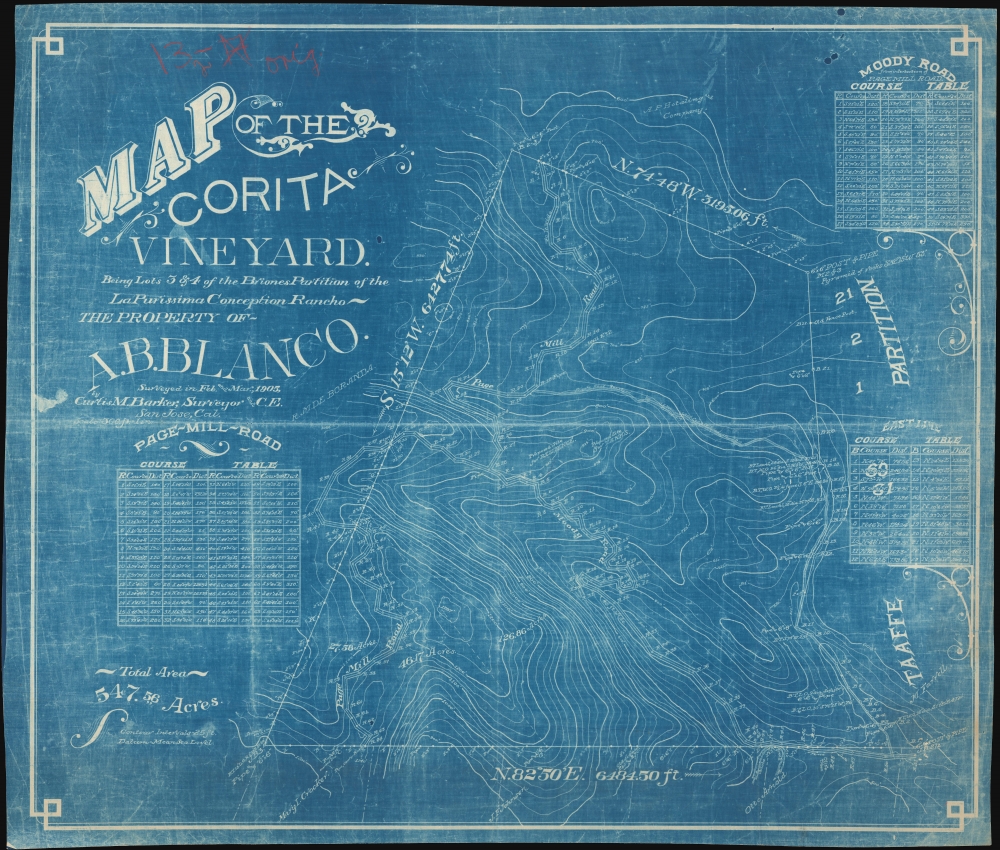


FOR THE ORIGINAL ANTIQUE MAP, WITH HISTORICAL ANALYSIS, CLICK HERE.
Digital Map Information
Geographicus maintains an archive of high-resolution rare map scans. We scan our maps at 300 DPI or higher, with newer images being 600 DPI, (either TIFF or JPEG, depending on when the scan was done) which is most cases in suitable for enlargement and printing.
Delivery
Once you purchase our digital scan service, you will receive a download link via email - usually within seconds. Digital orders are delivered as ZIP files, an industry standard file compression protocol that any computer should be able to unpack. Some of our files are very large, and can take some time to download. Most files are saved into your computer's 'Downloads' folder. All delivery is electronic. No physical product is shipped.
Credit and Scope of Use
You can use your digial image any way you want! Our digital images are unrestricted by copyright and can be used, modified, and published freely. The textual description that accompanies the original antique map is not included in the sale of digital images and remains protected by copyright. That said, we put significant care and effort into scanning and editing these maps, and we’d appreciate a credit when possible. Should you wish to credit us, please use the following credit line:
Courtesy of Geographicus Rare Antique Maps (http://www.geographicus.com).
How Large Can I Print?
In general, at 300 DPI, you should at least be able to double the size of the actual image, more so with our 600 DPI images. So, if the original was 10 x 12 inches, you can print at 20 x 24 inches, without quality loss. If your display requirements can accommodate some loss in image quality, you can make it even larger. That being said, no quality of scan will allow you to blow up at 10 x 12 inch map to wall size without significant quality loss. For more information, it is best consult a printer or reprographics specialist.
Refunds
If the high resolution image you ordered is unavailable, we will fully refund your purchase. Otherwise, digital images scans are a service, not a tangible product, and cannot be returned or refunded once the download link is used.
Curtis Mason Barker (April 12, 1861 - August 4, 1908) was an American civil engineer and surveyor. Born in Detroit Michigan, Barker was the third of three children. His father, Kirkland Charles Barker (September 8, 1819 - May 20, 1875) was a successful businessman in Detroit who owned the American Eagle Tobacco Works there. He also served as mayor of Detroit from 1865 - 1867. Curtis Barker was educated at the Michigan State University at Ann Arbor (today known as the University of Michigan), where he studied civil engineering and surveying. After graduating, firm in the belief that his job prospects were better further west, Barker moved to Colorado where he worked in the mines and as a surveyor for railroads. He moved to California in 1885, and lived and worked in Palo Also as an assistant civil engineer on the construction of Leland Stanford University. He then moved to San Jose in 1894 and opened his own surveying and civil engineering firm. Soon after moving to San Jose he was appointed city engineer and held the position until July 1, 1902. He died on August 4, 1908, when he drowned in Halfmoon Bay along the California coast while yachting. It is unclear if his death was an accident. Curiously, his father drowned while yachting on the Detroit River when Barker was a child. Barker married Zoe A. Campbell in 1883, with whom he had two daughters. More by this mapmaker...
Copyright © 2025 Geographicus Rare Antique Maps | Geographicus Rare Antique Maps
This copy is copyright protected.
Copyright © 2025 Geographicus Rare Antique Maps