1818 Humboldt Map of Part of the Course of the Orinoco River, Venezuela
CourseOroonoko-humboldt-1818$500.00

Title
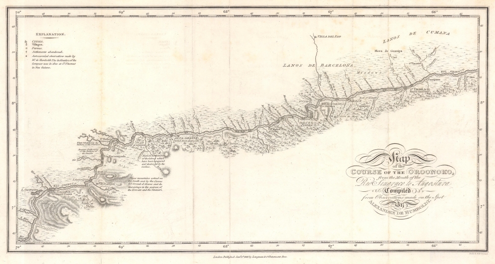
Map of the Course of the Oroonoko, from the Mouth of the Rio Sinaruco to Angostura. Compiled from Pobservations made on the Spot by Alexandre de Humboldt.
1818 (dated) 7.5 x 14.25 in (19.05 x 36.195 cm) 1 : 1400000
1818 (dated) 7.5 x 14.25 in (19.05 x 36.195 cm) 1 : 1400000
Description
This is an 1818 Alexander von Humboldt map of part of the Orinoco River in modern-day Venezuela. It was compiled to illustrate Humboldt's epic voyage through South America, resulting in his Cosmos, an era-defining scientific work.
A Closer Look
This map illustrates a stretch of the Orinoco River from the mouth of the Cinaruco River (Rio Sinaruco here) in the lower left corner to St. Ann, a village not far from the Orinoco's banks. Tributaries of the Orinoco appear in detail, and cities and villages along the river's course are marked and identified. Humboldt also notes areas inhabited by Indians as well as ancient settlements. The city San Thome de la Nueva Guayana is the modern-day city Ciudad Bolívar.Humboldt in South America
After Humboldt's securing the goodwill of the Spanish crown and permission to travel in Spanish America, Humboldt and his friend Aimé Bonpland (a French physician turned botanist) embarked for the New World from Spain in June 1799. Forty-one days later, they arrived in Cumaná, in the Captaincy General of Venezuela. Humboldt and Bonpland spent the next several months exploring the region around Cumaná before heading overland to Caracas. They left Caracas for the Orinoco River on February 7, 1800, intent on scientifically determining if there was a connection between the Orinoco and the Amazon Rivers. It took the explorers nearly two months to arrive at a tributary of the Orinoco, reaching the banks of the Apure on March 26, 1800. They spent the next 74 days traveling the vast river system, eventually determining with scientific precision the location of the Casiquiare River, which famously flows both ways, and connects the Orinoco River to the Río Negro, the largest tributary of the Amazon. Afterward, Humboldt and Bonpland spent the next 4 years traveling through Cuba, Colombia, Ecuador, Peru, and Mexico, where they were feted by both the political and scientific communities. They arrived in Philadelphia in May 1804. While in the United States, Humboldt was a guest of President Thomas Jefferson at Monticello.Publication History and Census
This map was compiled by Alexander von Humboldt, engraved by Samuel Neele, and published for the English edition of Personal Narrative of Travels to the Equinoctial Regions of the New Continent, 1749-1804 (Longman, 1818). One example of the separate map is cataloged in OCLC and is part of the collection at the University of Michigan. While the separate map is scarce, Humboldt's Personal Narrative, in its many editions, is well represented in institutional collections.CartographerS
Alexander von Humboldt (September 14, 1769 - May 6, 1859), whose full birth name is Friedrich Wilhelm Heinrich Alexander Freiherr von Humboldt was a German born naturalist, biologist, geologist, explorer and cartographer active in the late 18th and first half of the 19th century. The importance and scope of Humboldt's work is staggering and its influence on both the development of America and the development of science itself is second to none. As Emil Du Bois-Reymond said, "Every scientist is a descendant of Humboldt. We are all his family." To compose a full biography of Humboldt is the work of volumes, not this simple medium, so we will attempt to focus on the highlights of Humboldt's life as it pertains to cartography. Humboldt was the first scientist to embrace and actually take into the field the Kantian concept of a union between careful scientific observation and intuitive analysis. Between 1799 and 1804 Humboldt traveled through northwestern South America, Central America, Mexico, and parts of the United States. During this voyage he collected a wealth scientific observations and measurements, including considerable surveying and cartographic work, in each of the regions through which he passed. Humboldt's mapping of Mexico, then inclusive of much of the southwestern part of the United States, was an accomplishment of seminal importance, not only because it was the finest map of the region yet produced, but also because of its impact on the future political geography of the Americas. Upon his arrival in Washington, Humboldt struck up a friendship with president Thomas Jefferson, soon to be president James Madison, and other luminaries of post Colonial America. He freely shared his mappings of Mexico with the U.S. President, little suspecting that they would soon influence the results of the Mexican American War and the manifest destiny movement that would follow. When he returned to Germany, Humboldt began a life-long correspondence with scientific luminaries and explorers throughout the world and most particularly in America. Humboldt's influence can be directly tagged to the development of numerous important careers in American cartography, including those of Nicolette, Fremont, Wilkes, Hassler, Bache, and others. Though Humboldt never again visited America, his name is etched across our landscape through numerous Mountains, Rivers, Islands, and other geological features that bear his name. Had the votes in Congress swayed slightly to the other direction, even the entire state of Nevada would have been the state of Humboldt. Throughout his life, Humboldt was a tireless supporter of human equality, scientific advancement, and personal liberty. Humboldt died in Berlin at 89 years old, in his long life he was an inspiration to the invention of modern anthropology, the political destiny of South America, the geographical exploration of the American West, and, ultimately, the development of modern science. More by this mapmaker...
Longman (fl. c. 1720 - present) is a long lived and venerable British publishing firm initially founded 1720s by Thomas Longman (1699 - 1755). Longman was born in Bristol and in 1716 was apprenticed to John Osborn, a London printer and bookseller. Completing his apprenticeship, Longman requested and was granted the hand of Osborn's daughter. Shortly afterwards Longman acquired the stock of Robinson Crusoe publisher William Taylor and, along with Osborn, established a printing office on Paternoster Row. The two published numerous works including Samuel Johnson's Dictionary. Around the same time that Osborn retired Thomas Longman's nephew, another Thomas Longman (1730 - 1797), joined the firm which was subsequently renamed T. and T. Longman. On the death of the original Thomas Longman, the nephew took over the firm and eventually passed it on to his son, Thomas Norton Longman (1771 - 1842). Thomas Norton seemed to have had a passion for partnering and over the years added Owen Rees (1730 - 1797), Thomas Brown (c. 1777 - 1869), and three more mysterious partners, Hurst, Orme and Green, to the corporation's partner list. For many years the firm published as Longman, Hurst, Rees, Orme, Brown & Green. Thomas Norton eventually passed the firm to his own sons, Thomas and William, who during their tenure bought out most of the minor partners, renaming the firm Longmans, Green & Co. Later, Thomas Longman's son took control of the firm in full naming it just Longman. During World War II most of their plates and stock were destroyed but the company nonetheless survived and went public in 1948. Longman was eventually acquired by the media conglomerate Pearson and continues to publish as Pearson Longman. Learn More...
Samuel John Neele (July 29, 1758 - May 13, 1824) was a prolific British map engraver active in the late 18th and early 19th centuries. Neele apprenticed as a printer and engraver with Harry Ashby from about 1781 to 1782 before establishing himself independently in 1785 at 352 Strand, London. The combination of business acumen and technical skill made Neele extremely successful with literally hundreds of maps to his credit. His vast corpus was composed of notable maps by most major English publishers of the period including, Haywood, Faden, Wallis, Stockdale, Arrowsmith, Thomson, Pinkerton, and Greenwood, among others. Neele's sons, James and Josiah Neele, also engravers, took over their fathers business around 1818, both becoming notable in their own right. Learn More...
Source
Humboldt, A. von and Bonpland, A., Personal Narrative of Travels to the Equinoctial Regions of the New Continent, 1749-1804, (London) 1818.
Condition
Very good. Light wear along original fold lines. Verso repairs to fold separations. Light foxing.
References
OCLC 847605646.