This item has been sold, but you can get on the Waitlist to be notified if another example becomes available, or purchase a digital scan.
1930 Curtis Pictorial Map of New Orleans, Louisiana (Signed!)
CreoleCityNewOrleans-curtis-1930
Title
1930 (dated) 28.5 x 20.5 in (72.39 x 52.07 cm) 1 : 22000
Description
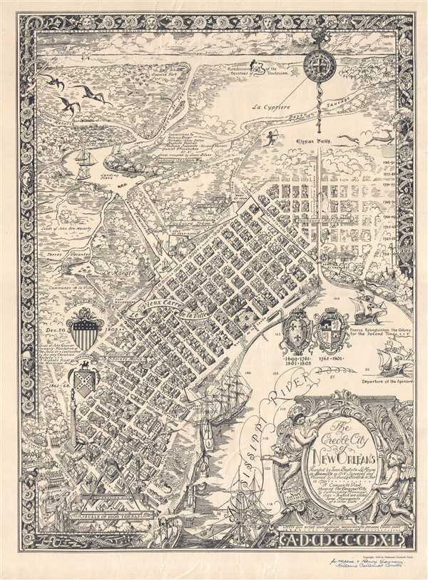
The St. Louis Cemetery and Fort St. Ferdinand are illustrated on the outskirts of the city, along with Fort St. Jean and the College of Orleans. The swamp and community gardens are also labeled outside the city, along with land owned by John Baptiste Macarty. The Canal Carondelet leads from the 'landing place' where the Custom House is illustrated along with the Faubourg St. Jean. A road, leading from the Custom House and the landing place connects with the Grand Chemin du Bayou St. Jean, which leads either into the city or along the Elysian Fields and La Cypriere. In the background, past more bayous, lies Lake Pontchartrain, with a 'rendezvous of the devotees of voudouism' illustrated along its banks.
Subtle lessons in New Orleans history are sprinkled throughout the map, with little explanation. The whole is surrounded by a wonderful pictorial border that includes the names of famous people from New Orleans and other aspects of New Orleans history. One such reference is a skull with a vine growing through one of its eye sockets that is placed conspicuously close to the coat of arms representing the city's time in the Confederacy. Four different coats of arms are illustrated near the city, two in the Mississippi River and two near the left border. The two in the Mississippi River coats of arms represent periods of French and Spanish dominance in the city. Two large sailing ships are illustrated near these coats of arms, representing the changes in power between the two nations in New Orleans. The third is dated December 20, 1803, the date of the official transfer of the Louisiana Territory from France to the United States. The fourth, as stated above, features the 'stars and bars' of the Confederate States of America and is situated next to the General Lee Monument, that is dated 1883 on this map. The statue was removed by the city in May 2017. The title cartouche, situated in the lower right corner, is held by two cherubs, one of which is wearing a mask. This may be a subtle gesture toward the city's Mardi Gras celebrations.
This map was created and published by Nathaniel Cortlandt Curtis in 1930. It appears that this example has been dedicated to two individuals by Mr. Curtis himself and is signed in the lower right corner.
Cartographer
Nathaniel Cortlandt Curtis (February 8, 1881 - April 15, 1953) was an American architect, historical preservationist, and illustrator. Born in Smithville (now Southport), North Carolina, Curtis was the head of the Department of Architecture at Tulane University in New Orleans from 1912 to 1917, when he left the city. In 1920, Curtis returned to New Orleans and began working for the architectural firm Goldstein, Parham, and Labouisse, a position he would retain until his death. He also taught part-time at Tulane. He wrote and published several books and novels, including New Orleans: Its Old Houses, Shops, and Public Buildings, which was published in 1933. His son, Nathaniel Jr. was also an artist and architect based in New Orleans. More by this mapmaker...

