This item has been sold, but you can get on the Waitlist to be notified if another example becomes available, or purchase a digital scan.
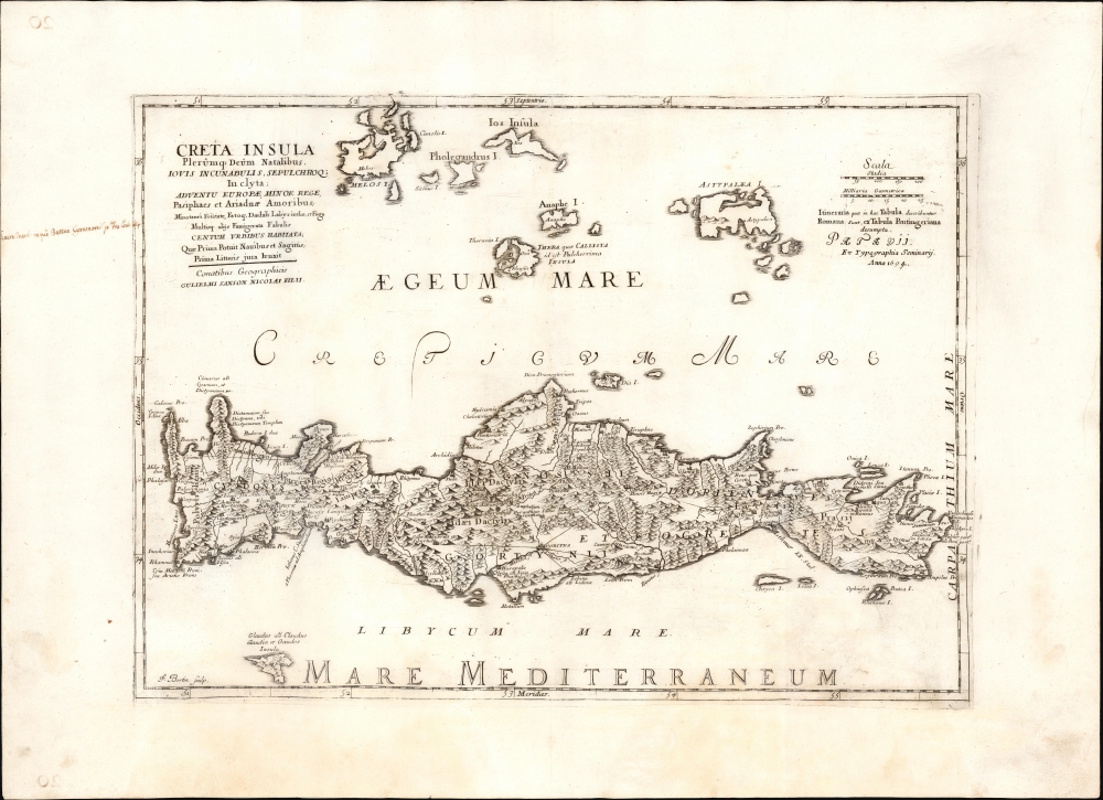
1694 Map of Crete and the Greek Islands after Sanson
Crete-sanson-1694
Title
1694 (undated) 15 x 20.75 in (38.1 x 52.705 cm) 1 : 900000
Description
A Closer Look
Sanson's geography followed the model of Francesco Basilicata. Zacharakis dubbed this model as 'unreservedly the best and most accurate outline of a map of Crete,' and the geographic establishment of the 17th and early 18th centuries agreed, as Basilicata's map remained the standard throughout the second half of the 17th century.Although the geography is drawn from the most up-to-date sources, place names reflect historical Roman toponymy. As is noted in the text of the map at the upper right, the roads marked on the map were drawn from the Tabula Peutingeriana - the only surviving example of an itinerarium pictum (Map of the ancient Roman road system, updated to the 4th century.) There are more place names here than can ascribed solely to that source, with additional content drawn from the 2nd Century Roman geography of Claudius Ptolemy.
Used For Study
Maps of this sort were produced as supplemental study aids for the Enlightenment Era restoration of classical texts. As such, surviving examples occasionally bear notations, as here in the left margin. This Latin note refers to the Greek island of Thera (also known as Callista, near the center of the map north of Crete ) and points it out as the birthplace of Battus, founder of the Ancient Greek colony of Cyrene (7th Century BCE.)Publication History and CensusThe map was initially engraved by one of the sons of Nicolas Sanson, in 1676. In 1694, the engraver F. Bertin (dates unknown) copied this and an array of Sanson's other maps for inclusion in Tabulae geographicae, quibus universa geographia vetus continetur, published in Padua by the Seminario Vescovile. We see only five examples of the book in OCLC, and a sole example of the separate map is held at the Sachsische Landesbibliothek.
CartographerS
Guillaume Sanson (1633 - 1703) was a French cartographer active in the latter part of the 17th century. He is the son of the legendary cartographer Nicolas Sanson (1600 - 1667), and, along with his brother Adrien Sanson (1639 - 1718), took over the family firm on his father's death. Like his father, Guillaume Louis XIV granted him the official title, Geographe Ordinaire du Roy. Much of his work after 1671 was published in collaboration with Alexis-Hubert Jaillot (c. 1632 - 1712). Although the continued to published new maps, particularly Guillaume Sanson, the firm began to lose prestige and market share. In 1692, the brothers sold their geographical archive to their nephew Pierre-Moulart Sanson (1670 - 1730), who published a map catalog in 1696 and reissued the Sanson atlas. After Pierre-Moulart's death, many of the surviving map plates were acquired by Gilles Robert de Vaugondy, setting the stage for another French cartographic dynasty. More by this mapmaker...
Francesco Basilicata (???? – c. 1640) was a 17th century Italian cartographer and military engineer. Basilicata worked in the service of the Republic of Venice and is known for his maps and drawings of the island of Crete. Little is known of his early life, but it has been suggested that he may have been from Palermo. He lived in Crete during the first two decades of 17th century, in the last days of Venetian hegemony over the island. Basilicata fell in love with the island's rugged scenery and spent the years between 1612 and 1629 meticulously mapping the entire island. His maps of Crete from the foundation for must subsequent maps until the early 18th century. Learn More...

