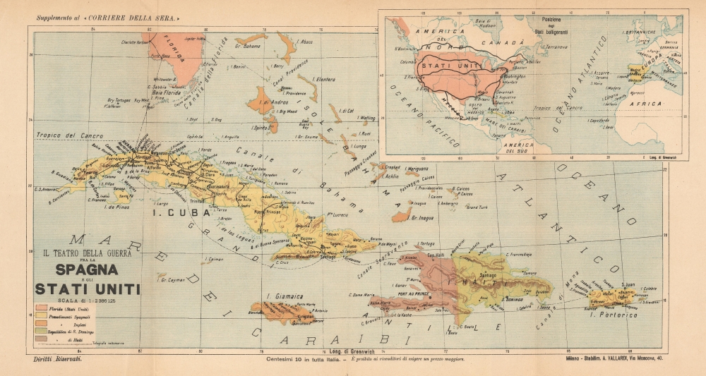
1898 Vallardi Map of Cuba and Puerto Rico During the Spanish-American War
CubaSpanishAmericanWar-vallardi-1898
Title
1898 (undated) 12 x 22 in (30.48 x 55.88 cm) 1 : 2386125
Description
A Closer Look
Focusing on the Greater Antilles, the map depicts from Cuba to Puerto Rico and illustrates those two islands and Hispaniola, Jamaica, and the Bahamas. Colors identify colonial powers, such as Spain (yellow) and England (orange), as well as the independent nations of Haiti and the Dominican Republic. Extreme southern Florida appears along the top border. An extensive railway network appears in Cuba, with cities and towns labeled, along with coastal capes, points, and smaller islands. The same detail is provided for the other islands, although no other railways exist. Dashed lines highlight shipping routes from Florida through the islands. An inset in the upper right corner situates Cuba and Puerto Rico in relation to the two belligerents, the United States and Spain.The Spanish-American War
The Spanish-American War was fought between Spain and the United States between April 21, 1898, and August 13, 1898. The war started after the USS Maine suffered a massive explosion and sank in Havana Harbor. Tensions had been rising between the two countries for some time, with the U.S. showing support for Cuban independence while Spain claimed Cuba to be a province of Spain. The Spanish were quickly outclassed and outnumbered by the U.S. forces and surrendered after minimal conflict. After the fighting ended, the U.S. received the Philippines, Guam, and Puerto Rico along with Cuba as a U.S. protectorate.Publication History and Census
This map was created and published by Antonio Vallardi in 1898 in a supplement to the Corriere della Sera. A single example is cataloged in OCLC - Biblioteca Civica di Arco. A handful of examples have appeared on the private market.Cartographer
Antonio Vallardi (1813 - 1876) was an Italian publisher and founder of the Antonio Vallardi publishing house. Born into a Milanese publishing family, his grandfather Cesare Vallardi (1736 - 1799) began publishing books in Contrada Santa Margherita in the 1750s. Vallardi's father, Pietro (1770 - 1819), and uncle Giuseppe (1784 - 1861) continued their father's publishing business but renamed the company Fratelli Vallardi and became prominent publishers of books and art prints. Pietro's sons, Franceso and Antonio, both founded their own publishing houses. Antonio Vallardi opened his publishing house in 1843, three years after his brother. Antonio's publishing house became known for academic and linguistic works, alongside the many maps and guides it published for the Touring Club. Antonio's descendants operated the publishing house until 1970, when they sold the firm to Garzanti. More by this mapmaker...

