This item has been sold, but you can get on the Waitlist to be notified if another example becomes available, or purchase a digital scan.
1877 Ruger Map of the Cumberland Gap, Tennessee during the American Civil War
CumberlandGap-ruger-1877$175.00

Title
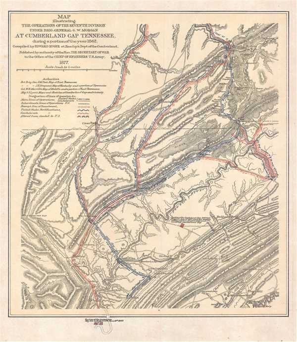
Map illustrating the Operations of the Seventh Division under Brig. General G.W. Morgan at Cumberland Gap Tennessee, during a portion of the year 1862.
1877 (dated) 14.5 x 12.5 in (36.83 x 31.75 cm) 1 : 253440
1877 (dated) 14.5 x 12.5 in (36.83 x 31.75 cm) 1 : 253440
Description
This is a separate issue 1877 Edward Ruger map of the Cumberland Gap, a narrow pass through the Cumberland Mountains, which are part of the Appalachian Mountains, during the American Civil War. The Cumberland Gap holds a near mythic position in the history of colonial America as one of the key passageways through the lower central Appalachian Mountains and as part of the Wilderness Road. Situated at the junction of Kentucky, Tennessee, and Virginia, the map depicts a portion of all three states, stretching from the Cumberland River to Clinton and from Jellico Mount to Tazewell. The movements of both Union and Confederate forces through the gap are traced, allowing the viewer to understand that in 1862 the Gap changed hands at least twice.
The Cumberland Gap during the American Civil War
Confederate forces originally occupied and fortified the Cumberland Gap in the fall of 1861 and held the area until the summer of 1862, when the forces holding the Gap were ordered to help with the defense of Chattanooga. At that time Union general George Morgan and his men occupied the region and strengthened the fortifications. Morgan held the Gap until September 1862, when he chose to abandon it after Confederate General Edmund Kirby Smith invaded Kentucky. The Confederacy would hold onto the Gap until late summer 1863, when Union General Ambrose Burnside launched an offensive against Knoxville and also captured the region around the Cumberland Gap. Union forces would not cede the region to the Confederates again during the war.
The advance of Generals Smith and Morgan are traced here, along with Morgan's retreat from the area following Smith's invasion of Kentucky. Union and Confederate fortifications are also illustrated, along with those that changed from Confederate positions to Union ones. Numerous towns and other settlements are labeled, along with various ridges, mountains, and mounts. Rivers and creeks are also illustrated and labeled.
this map was compiled by Edward Ruger and published by authority of the Secretary of War in the Office of the Chief of Engineers in 1877. While represented in institutional collections, this map is rarely seen on the market.
Cartographer
Edward Ruger (September 16, 1834 - May 18, 1918) was an American engineer and soldier. Born in Lima, New York, Ruger (one of nine children) was the second son and third child of Thomas Jefferson and Maria (Hutchins) Ruger. Ruger's parents moved to several different towns within the state of New York during his youth, and at one point attended public school in Marcellus, New York. In 1844, Ruger's family moved to Janesville, Wisconsin, where he father served as a home missionary of the Protestant Episcopal church. In Janesville, Ruger attended public school and then the Janesville Academy, where his father was the first principal. However, Ruger only formally attended school for the three winter months of the year, with his father administering his schoolwork during the rest of the year so Edward could work on the family farm. Edward Ruger's father was an accomplished mathematician, which led the younger Ruger to study mathematics and a love of civil engineering and surveying. In 1857, Ruger opened a surveying office in Janesville, bringing with him experience surveying land for the United States, subdividing sections, and making preliminary and locating surveys for railroads and their construction. Ruger was elected city engineer of Janesville in 1859, and county surveyor of Rock County in 1860. He gave up these posts in 1861 when he enlisted in the Union Army and was enrolled as captain of Company A, Thirteenth Wisconsin Volunteer Infantry. He and his regiment left Janesville in January 1862 and moved their way south to Kansas, eventually to Fort Riley. After leaving Fort Riley, he and his regiment were given the task of rebuilding bridges that had been destroyed by Confederate troops. Eventually, Ruger was named a topographical engineer and served in such capacity on the staffs of Major General Lovell H. Rausseau and Major General George H. Thomas. When he joined General Thomas's staff, he was placed in the position of superintendent of the topographical engineer's office of the Army of the Cumberland, a post he kept until 1869. He made surveys and drew maps of the operations of the Army of the Cumberland during the war and the operations of the Armies of the Tennessee and Ohio during the Atlanta Campaign. When Ruger returned to Janesville after leaving the Army, he again opened a civil engineering and surveying office. Beginning in 1874, he was almost completely engaged in hydraulic engineering, receiving contracts in that field from twenty-three different states. Ruger married Sarah B. Wright on August 23, 1862 in Janesville during a thirty-day leave from the Army. He and Sarah had two sons, Frank and Harry. More by this mapmaker...
Condition
Very good. Even overall toning. Blank on verso.
References
LOC G3964.C942S5 1877 .R8. Stephenson, R. W., Civil War Maps; an Annotated List of Maps and Atlases in Map Collections of the Library of Congress, 407.