This copy is copyright protected.
Copyright © 2025 Geographicus Rare Antique Maps
1603 Ortelius Map of Cyprus
Cyprus-ortelius-1573
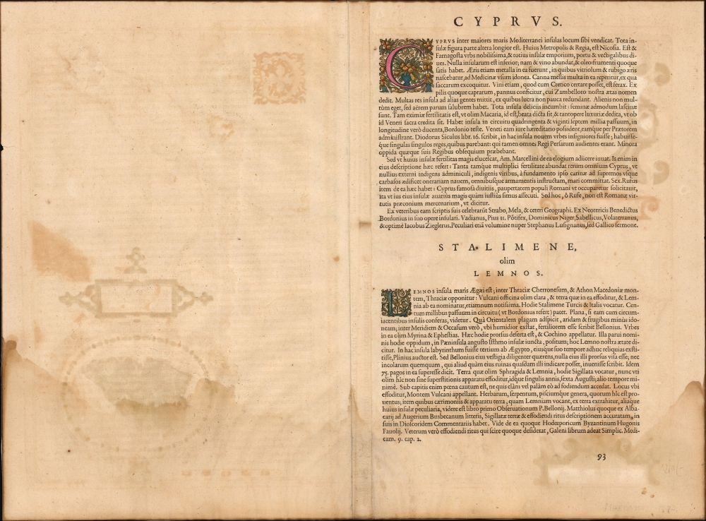


Abraham Ortelius (April 14, 1527 - June 28, 1598) also known as Ortels, was a cartographer, geographer, and cosmographer of Brabant, active in Antwerp. He was the creator of the first modern atlas, Theatrum Orbis Terrarum and is a seminal figure in the history of cartography. Along with Gerard Mercator and Gemma Frisius, he was a founder of the Netherlandish school of cartography. His connections with Spain - culminating in his 1575 appointment as Royal Cartographer to King Phillip II of Spain - gave him unmatched access to Spanish geographical knowledge during a crucial period of the Age of Discovery. Ortelius was born in 1527 in Antwerp. In 1547 he entered the Antwerp Guild of Saint Luke as an illuminator of maps. He began trading in books, prints, and maps, traveling regularly to the Frankfurt book and print fair, where in 1554 he met Mercator. He accompanied Mercator on journeys throughout France in 1560 and it was at this time, under Mercator's influence, that he appears to have chosen his career as a scientific geographer. His first published geographic work appeared in 1564, an eight-sheet cordiform world map. A handful of other maps preceded the 1570 publication of the first edition of the Theatrum Orbis Terrarum, which would prove to be his life work. Appearing with but 53 maps in its first edition, Ortelius' work expanded with new maps added regularly. By 1592, it had 134 maps. Many of Ortelius' maps remained the standard for nearly a century. He traveled extensively, but his genius was as a compiler, locating the best informed maps on which to base his own. His contacts throughout Europe and extending even (via the Portuguese) to the Far East were formidable. Moreover, many of his maps were based on his own scholarship, particularly his historical works. His theories of geography were particularly ahead of his time with respect to the notion of continental drift, the possibility of which he mused on as early as 1596, and which would be proven correct centuries later.
In a sense his greatest achievement was his successful navigation of the religious and political violence endemic to his city throughout his adult life: The Dutch Revolt, or Eighty Years' War (1568 - 1648), fully embroiled Antwerp. Although outwardly and officially recognized as Catholic (Arias Montanus vouched for Ortelius' Catholic orthodoxy prior to his appointment as Royal Geographer), Ortelius was able to separate himself from the religious furor which characterized the war in the low countries. Ortelius showed a glimpse of himself in a letter to a friend, regarding humanist Justus Lipsius: 'I do not know whether he is an adherent of the Pope or a Calvinist, but if he has ears to hear, he will neither be one nor the other, for sins are committed on both sides'. Ortelius' own explorations of Biblical history in his maps, and the Christogram contained in his own motto, suggest him to be a religious man, but his abjuration of political religious authorities mark him as an individualist. His tombstone at St Michael's Præmonstratensian Abbey in Antwerp bears the inscription, Quietis cultor sine lite, uxore, prole. ('served quietly, without accusation, wife, and offspring.') More by this mapmaker...
Johannes Baptista Vrients (1552 - 1612) was a Flemish engraver, publisher, and mapseller. Little is known of his early years, but it is to be assumed he came up as an apprentice among the mapmakers of Antwerp, where the guild named him a master in 1575. In the 1590s, he executed world maps for Plancius and Linschoten. (In 1600, after Ortelius died, he became the estate's executor and acquired the plates for the Theatrum.) He would go on to publish further editions of the Ortelius atlas between 1606 and 1612. Vrients also acquired the plates for Gerard De Jode's (1516/17 - 1591) Speculum in and around 1600, but he did not republish that work - though he would preserve the De Jode plates depicting the Electors of the Holy Roman Empire, reprinting it in his editions of the Ortelius atlas after 1603. Most likely, his purchase of the De Jode plates was a play to keep them off the market. Vrients' editions of the Theatrum were not published in Antwerp (that city having fallen during the Dutch war with Spain) but in Amsterdam. Learn More...
Giacomo Franco (1550 - c. 1620) was a Venetian engraver and publisher; in his will he described himself as 'desegnador,' and he was listed as a member of the Venetian painters' guild. He was the son of painter and engraver Battista Franco. He was regarded chiefly as an illustrator, being known mostly for two works describing Venetian costume. He published Giuseppe Rosaccio's 1605 Viaggio Da Venetia a Costantinopoli, and his imprint appears on at least one of the maps in that work - a general chart of the Turkish - held Mediterranean. He also contributed at least one map to Rosaccio's 1598 edition of Ramusio's Ptolemy, a modern map of Hungary and Transylvania. Tooley attributes a 1589 plan of Rome to him. Bifolco and Ronca identify many works belonging to Franco, including several plans of Venice, Rome, and a fine map of Cyprus. Learn More...
Copyright © 2025 Geographicus Rare Antique Maps | Geographicus Rare Antique Maps
This copy is copyright protected.
Copyright © 2025 Geographicus Rare Antique Maps