This item has been sold, but you can get on the Waitlist to be notified if another example becomes available, or purchase a digital scan.
1864 Artaria Map of the Danube River: Bavaria, Austria, Hungary, Romania
Danube-artaria-1864$375.00


Title
Carte du cours du Danube depuis Ulm jusqu'à son embouchure dans la Mer noire Guide de Voyage a Constantinople sur le Danube avec indication de tous les points de la Navigation des Pyroscaphes sur cette route.
1864 (undated) 21 x 30 in (53.34 x 76.2 cm) 1 : 2250000
1864 (undated) 21 x 30 in (53.34 x 76.2 cm) 1 : 2250000
Description
A beautiful 1864 Artaria map harkening to the romantic early days of steam navigation on the Danube.
A Closer Look
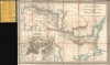
Coverage embraces southeastern Europe centered on the Danube between Ulm, Germany, and the Danube Delta on the Black Sea. The route of steamships, here called pyroscaphes, is detailed, with hundreds of stops named and major stops underscored in red. The map includes a vignette of a sidewheel steamship in the lower left, with promotions for the Compagnie J. et R. Autrichienne du Danube, the Compagnie Autrichienne du Danube, the Compangie Lloyd Austricao, and the Compagnie J. er R. et les Bateaux Russes. An inset city plan of Constantinople (Istanbul) dominates the lower left.Steam Navigation on the Danube
In the mid-19th century, steam navigation on the Danube River revolutionized trade and travel in Central and Eastern Europe. The introduction of steam-powered vessels, beginning in the 1830s, significantly improved the efficiency and reliability of river transportation compared to traditional sailing ships and barges. This advancement was spearheaded by companies like the Compangie Lloyd Austricao and the Compagnie Autrichienne du Danube, which facilitated regular passenger and cargo services. The steamships enabled quicker and more predictable transit times, fostering regional economic growth and integration. Major ports like Vienna, Budapest, and Galați became bustling hubs of activity, linking the heart of Europe with the Black Sea and beyond. The development of steam navigation on the Danube also had profound social impacts, enhancing mobility and connectivity for people along the river’s extensive route.Publication History and Census
This map was published by Artaria in Vienna from about 1837 to 1865. While there are variations between examples, it is mostly in Artaria imprint and the promoted steamship companies, rather than geographical content - which did not change significantly. This example has been roughly dated according to the advertised Artaria publications on the promotional endpaper, the last date of which is 1864. However, this may be an earlier example c. 1855 that was simply bound for sale with newer endpapers, as geographically little changed. The map is scarce on the market and in institutions.Cartographer
Artaria and Company (1765 - c. 1890) was founded by Carlo Giovanni Artaria in 1765 in Vienna, then the capital of the Austro-Hungarian Empire. Originally a specialty publisher of sheet music, including works by Hayden, Mozart, Beethoven, and Schubert, the company had expanded its business to include maps by the mid-1770s. The company collaborated with Joseph von Scheda and distributed maps for the Militärgeografischen Institutes. Artaria continued to be a major European publisher well into the 20th century. In 1920, the cartographic section was sold to Freytag and Berndt, who published under the imprint Freytag-Berndt & Artaria. More by this mapmaker...
Condition
Very good. Laid on original linen. Stable.
References
OCLC 156044635.