1950 City Plan Commission Plan of Detroit, Michigan
Detroit-cityplancommission-1950$1,250.00

Title
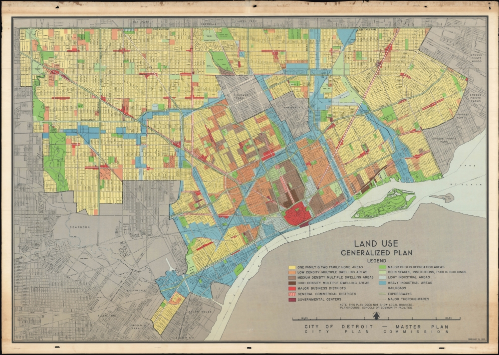
Land Use Generalized Plan / City of Detroit - Master Plan.
1950 (dated) 26 x 38.5 in (66.04 x 97.79 cm) 1 : 33000
1950 (dated) 26 x 38.5 in (66.04 x 97.79 cm) 1 : 33000
Description
This rare 1950 map of Detroit, Michigan, produced by the City Plan Commission, is Detroit's official master plan during its height as the heart of the American and the global automotive industry. It is an infographic masterpiece, recording a wide array of land-utilization data essential to managing the fourth-largest city in the United States.
Being a mid-century representation of Detroit, we are privy to a time of significant expansion and growth, during which Detroit had become the fourth largest city in the country. This was largely due to the allure of the city's almost 300,000 manufacturing jobs. The Master Plan, as it is called, was commissioned by the City Planning Commission to visualize the different ways urban space was utilized. This was done through a system of color coding that differentiates between different use-characteristics. The wide array of uses naturally means that a broad spectrum of colors was necessary, lending the map part of its aesthetic quality. The color code allows us to distinguish between institutions and public buildings, residential dwellings, major businesses, and general commercial districts but also has separate shading for areas of light and heavy industry. Within the residential areas alone, the map even subdivides housing into one- and two-family homes. Major public recreation areas are noted in a darker green than smaller open spaces. The map does not include other public spaces such as playgrounds, schools, and community facilities, revealing the limited municipal interest in such features.
A Closer Look
The city of Detroit is displayed with roads, rail lines, major parks, cemeteries, the city airport (now the Coleman A. Young International Airport), and other features indicated. Nearby cities and towns are also noted, including the enclaves of Hamtramck and Highland Park, as well as industrial suburbs like Dearborn and River Rouge.Being a mid-century representation of Detroit, we are privy to a time of significant expansion and growth, during which Detroit had become the fourth largest city in the country. This was largely due to the allure of the city's almost 300,000 manufacturing jobs. The Master Plan, as it is called, was commissioned by the City Planning Commission to visualize the different ways urban space was utilized. This was done through a system of color coding that differentiates between different use-characteristics. The wide array of uses naturally means that a broad spectrum of colors was necessary, lending the map part of its aesthetic quality. The color code allows us to distinguish between institutions and public buildings, residential dwellings, major businesses, and general commercial districts but also has separate shading for areas of light and heavy industry. Within the residential areas alone, the map even subdivides housing into one- and two-family homes. Major public recreation areas are noted in a darker green than smaller open spaces. The map does not include other public spaces such as playgrounds, schools, and community facilities, revealing the limited municipal interest in such features.
Making Motor City
While the city and people of Detroit have suffered much economic hardship in recent decades, when this map was published Detroit was a true boom-town. In 1950, its population reached 1.85 million, making it the country's fourth-largest city. It was known as 'Motor City' due to the massive automobile industry in and around Detroit. As mentioned, it sported almost 300,000 manufacturing jobs at the end of World War II. While parts of the automobile industry had set up shop in Detroit in the 1930s, the war meant that demand for industrial production surged and that the number of employees followed suit. Companies like Studebaker, Packard, and Hudson all saw tremendous growth during the war, and this growth was at least partly sustained afterward by a new form of consumerism. Consequently, what started as a small town on the land bridge between Lake Huron and Lake Erie had, by the end of the 1940s, become one of America's industrial hubs.Publication History and Census
This map was prepared by the City Plan Commission in 1950. It is noted among the holdings of eleven institutions in the OCLC and is rarely seen on the private market.Condition
Very good. Wear and toning in margins, with pinholes for hanging. On strong, linen-backed paper.
References
OCLC 43971117.


