1837 Tardieu Map of the Madura Strait, Indonesia

DetroitMadura-tardieu-1837
$1,000.00
Plan du Détroit de Madura depuis la Pointe Panka jusqu'a l'Embouchure de la Rivière de Sourabaya. - Main View
Processing...

1837 Tardieu Map of the Madura Strait, Indonesia

DetroitMadura-tardieu-1837

Defending the Dutch East Indies against the British.
$1,000.00

Title


Plan du Détroit de Madura depuis la Pointe Panka jusqu'a l'Embouchure de la Rivière de Sourabaya.
  1837 (undated)     25 x 17.75 in (63.5 x 45.085 cm)     1 : 69000

Description


This is an 1837 Ambroise Tardieu map of the Madura Strait between the islands of Java and Madura in Indonesia.
A Closer Look
With Java on the left and Madura on the right, the map illustrates the Madura Strait from the north end to the mouth of the Surabaya River. Depth soundings are noted, and the course of the Thétis is traced through the strait, suggesting the safest route. The Fort d'Orange occupies Menaris Island near the north end of the strait. This is the historic Fort Lodewijk, constructed in 1808 on the orders of the Governor General of the Dutch East Indies, Herman Willem Daendles, to defend against British incursions from the northwest. Towns are labeled on both islands. A view of the Fort d'Orange and the entrance to Madura Strait appears along the bottom border.
The Voyage Around the World by Hyacinthe de Bougainville
Hyacinthe Yves Philippe Florentin de Bougainville (December 26, 1781 - October 18, 1846) was a French admiral and the son of the famous navigator Louis-Antoine de Bougainville who successfully completed the first French circumnavigation. The younger Bougainville began his circumnavigation from Brest, France, when he left on March 2, 1824, and returned to Brest on June 23, 1826. Bougainville commanded the frigate Thétis and the corvette Espérance. The French government gave Bougainville secret orders to scout British strongholds throughout the Pacific. The voyage made numerous stops over the 27-month voyage, calling at Pondicherry, Manila, Macau, Singapore, Surabaya, Madura, Port Jackson (Sydney), Hobart, Valparaiso, and Rio de Janeiro. This expedition was the first European expedition to explore and map the Anambas Islands, and it was among the first French expeditions to visit Singapore.
Publication History and Census
This map was engraved by Ambroise Tardieu after work done by Edmond Bigot de la Touanne during Bougainville's voyage with the lettering engraved by J. P. Besançon. It was published in 1837 in the atlas that accompanied Bougainville's Journal de la Navigations Autour du Globe de la Frégate la Thétis et de la Corvette l'Espérance Pendant les années 1824, 1825 et 1826. We note a single cataloged example of the separate map at the Muséum National d'Histoire Naturelle in Paris, France. An empty OCLC reference appears for this work, suggesting that an institution that was once part of OCLC cataloged it at one point.

CartographerS


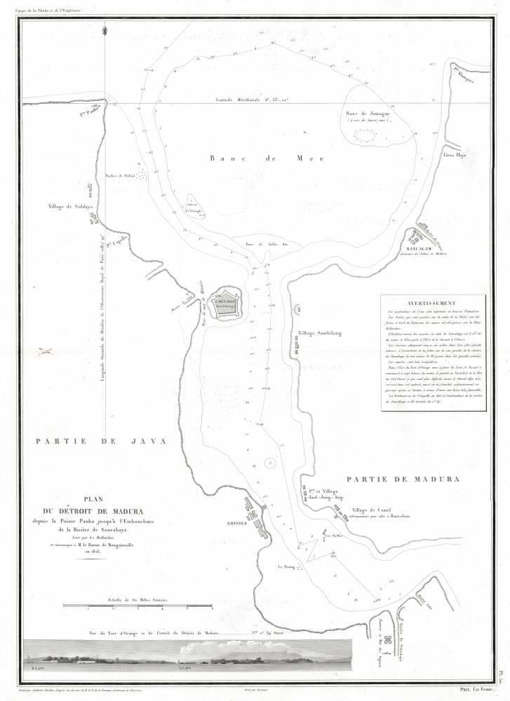
Ambroise Tardieu (March 2, 1788 - January 17, 1841) was a prominent French cartographer and engraver operating in the late 18th and early 19th centuries. He was member of the large and prolific Tardieu family, which, for over 200 years, produced multiple skilled and active engravers. Tardieu's work is known for its beauty and accuracy as well as for its depth of detail. Tardieu's most important work is his version of John Arrowsmith's large format map of the United States, published in 1806. Ambroise Tardieu is eclipsed in fame by his son, artist and medical scholar, August Ambroise Tardieu. Ambroise Tardieu is also frequently confused with Jean Baptiste Pierre Tardieu, another unrelated French map and print engraver active in the early 19th century. More by this mapmaker...


J.P. Besançon (fl. c. 1798 - 1835) was a French engraver who specialized in lettering. Besançon began engraving nautical charts for Charles-François Beautemps-Beaupré (August 6, 1766 - March 16, 1854) in 1802. He engraved eighty-three maps for Beautemps-Beaupré, then the hydrographer in chief, between 1802 and 1831, when he handed off the work to J.M. Hacq. Little else is known about Besançon's life and career. Learn More...


Edmond Bigot de la Touanne (May 3, 1796 - October 27, 1863) was a French topographical artist and naval officer. La Touanne served as a lieutenant on Hyacinthe de Bougainville's voyage around the world in 1824 - 1826. The French government had given Bougainville secret orders to scout the defenses of British settlements in the South Seas. Thus, while they were in Port Jackson, La Touanne, Bougainville, and other expedition members extensively explored the colony, and La Touanne created a detailed map of Port Jackson. In 1828, La Touanne published a folio of 35 lithographic views relating to the voyage entitled Album Pittoresque de la Frégate La Thétis et de la Corvette l'Espérance. In 1837, when Bougainville's Journal of the expedition was published, all 56 of its lithographed plates, views, and maps were done after La Touanne's work. Learn More...

Source


Bougainville, Hyacinthe de, Journal de la Navigations Autour du Globe de la Frégate la Thétis et de la Corvette l'Espérance Pendant les années 1824, 1825 et 1826, Atlas Volume, (Paris: Arthis Bertrand) 1837.    

Condition


Very good.

References


OCLC 556483233.