This item has been sold, but you can get on the Waitlist to be notified if another example becomes available, or purchase a digital scan.
1662 Blaeu Set of Maps of the Dnipro (Dnieper) River, Ukraine
DniproRiver-blaeu-1662$2,500.00


Title
Tractus Borysthenis, Vulgo Dniepr er Niepr dicti.
1662 (undated) 15 x 21 in (38.1 x 53.34 cm)
1662 (undated) 15 x 21 in (38.1 x 53.34 cm)
Description
A beautiful 1662 original-color set of Joan Blaeu maps of the Dnipro (Dnieper) River, the Ukrainian frontier of the Polish-Lithuanian Commonwealth. At the time, the region was undergoing a radical rearrangement, with Poland-Lithuania ejected as the major outside power and replaced by Tsarist Russia.
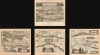
The first map, subtitled 'A civitate Czyrkassi ad ostia et Ilmien lacum, per quem in Pontum Euxinum se exonerate,' covers the area from Cherkasy to the Black Sea. The following three maps ('A Kiovia usque ad Bouzin,' 'A Bouzin usque ad Chortyca Ostrow,' and 'A Chortica Ostro ad Urbem Oczakow') are sequential, following the Dnipro southwards from Kyiv (Kiev, here as Kiow or Kiovia) to the Black Sea, although each has a slightly different orientation and scale.
The first map differs markedly from the following three. It is oriented with west at top and north at right, and is at a much larger scale, covering some two-thirds of the territory included in the subsequent three maps combined. Instead of or in addition to Beauplan, it might have been influenced by Tomasz Makowski's 1613 map of the Grand Duchy of Lithuania (also known as 'Radziwiłł map'), which was also published by (Willem) Blaeu. The map indicates destroyed Christian settlements ('Arx vel oppidium Christianorum dirutum'), likely a reference to periodic fighting with the Tatars and the Crimean Khanate to the south, an interpretation supported by the verso text. This notation did not appear in Makowski's 1613 map and might have been included by Blaeu to reflect subsequent hostilities in the area.
Over the following decades, the nobility associated more and more with Polish culture, causing a rift with the commoners, which became more pronounced in the 17th century as the Polish crown became a bastion of strict, Counter-Reformation Catholicism. Meanwhile, the localized Orthodox religious practices were under pressure from Moscow, which claimed ecclesiastical authority over all Christians in the area. Moreover, the Dnipro was the core of a militarized frontier dominated by Zaporizhian Cossacks who maintained an uneasy relationship with both Poland-Lithuania and the Tsar, being employed by Poland-Lithuania as a bulwark against Tatars.
In 1648, these tensions combined to shatter the uneasy equilibrium on the frontier. The leader (Hetman) of the Ukrainian Cossack nobility, named Bohdan Khmelnytsky, led an uprising of nobility, peasants, and Crimean Tatars against Polish-Lithuanian authority. Although it ranged as far as Lviv and the most intense battles took place in what is now in central and western Ukraine, the Dnipro was the heartland of the uprising, which besieged several fortresses including Cherkasy and entered Kyiv on Christmas Day 1648. The rebellion succeeded in creating an independent state, the Cossack Hetmanate, but this was accomplished at the cost of aligning with the Tsar in Moscow against Poland-Lithuania. Over time, the Tsar and the ecclesiastical authorities in Moscow exerted greater and greater control in the Ukrainian Cossack lands and by the end of the 18h century effectively incorporated them into the Russian Empire.
A Closer Look
The maps are based on the cartography of the Franco-Polish cartographer, engineer and architect Guillaume Levasseur de Beauplan. The maps follow the Dnipro (Dnieper) River in what is today eastern Ukraine. The title and descriptive notes are in Latin, while placenames are rendered in Polish, as Beauplan was in the service of the Polish crown and the region fell within the Polish-Lithuanian Commonwealth. Settlements, fortresses, and geographic features are indicated in detail throughout. All the maps contain the title 'Tractus Borysthenis [Herodotus' name for the region], vulgo Dniepr et Niepr dicti' followed by a unique subtitle, and each sheet is divided in half to allow for greater coverage of the long river. Each is also decorated with an elaborate cartouche depicting local Cossacks; the set is illuminated with superb original color.The first map, subtitled 'A civitate Czyrkassi ad ostia et Ilmien lacum, per quem in Pontum Euxinum se exonerate,' covers the area from Cherkasy to the Black Sea. The following three maps ('A Kiovia usque ad Bouzin,' 'A Bouzin usque ad Chortyca Ostrow,' and 'A Chortica Ostro ad Urbem Oczakow') are sequential, following the Dnipro southwards from Kyiv (Kiev, here as Kiow or Kiovia) to the Black Sea, although each has a slightly different orientation and scale.
The first map differs markedly from the following three. It is oriented with west at top and north at right, and is at a much larger scale, covering some two-thirds of the territory included in the subsequent three maps combined. Instead of or in addition to Beauplan, it might have been influenced by Tomasz Makowski's 1613 map of the Grand Duchy of Lithuania (also known as 'Radziwiłł map'), which was also published by (Willem) Blaeu. The map indicates destroyed Christian settlements ('Arx vel oppidium Christianorum dirutum'), likely a reference to periodic fighting with the Tatars and the Crimean Khanate to the south, an interpretation supported by the verso text. This notation did not appear in Makowski's 1613 map and might have been included by Blaeu to reflect subsequent hostilities in the area.
Historical Context
Before he became a cartographer, Beauplan was tasked with building or renovating forts on the eastern frontier of the Polish-Lithuanian Commonwealth along the Dnipro River (including Krzemienezyk / Kremenchuk and Kudac / Kodak, seen here). From the 14th century, this area formed a southern frontier of the Grand Duchy of Lithuania and saw frequent fighting with Tatars and 'Turks' (both the Ottomans and their allies the Crimean Khanate). When Poland and Lithuania were joined in the late 16th century, the local (Ruthenian) nobility pledged suzerainty to the Commonwealth in exchange for confirmation of their land rights.Over the following decades, the nobility associated more and more with Polish culture, causing a rift with the commoners, which became more pronounced in the 17th century as the Polish crown became a bastion of strict, Counter-Reformation Catholicism. Meanwhile, the localized Orthodox religious practices were under pressure from Moscow, which claimed ecclesiastical authority over all Christians in the area. Moreover, the Dnipro was the core of a militarized frontier dominated by Zaporizhian Cossacks who maintained an uneasy relationship with both Poland-Lithuania and the Tsar, being employed by Poland-Lithuania as a bulwark against Tatars.
In 1648, these tensions combined to shatter the uneasy equilibrium on the frontier. The leader (Hetman) of the Ukrainian Cossack nobility, named Bohdan Khmelnytsky, led an uprising of nobility, peasants, and Crimean Tatars against Polish-Lithuanian authority. Although it ranged as far as Lviv and the most intense battles took place in what is now in central and western Ukraine, the Dnipro was the heartland of the uprising, which besieged several fortresses including Cherkasy and entered Kyiv on Christmas Day 1648. The rebellion succeeded in creating an independent state, the Cossack Hetmanate, but this was accomplished at the cost of aligning with the Tsar in Moscow against Poland-Lithuania. Over time, the Tsar and the ecclesiastical authorities in Moscow exerted greater and greater control in the Ukrainian Cossack lands and by the end of the 18h century effectively incorporated them into the Russian Empire.
Publication History and Census
These maps appeared in Joan Blaeu's Atlas Major, based on earlier maps by Guillaume Levasseur de Beauplan, namely his eight-sheet wall map 'Delineatio specialis et accurata Ukrainae,' first engraved in 1650 by Willem Hondius, a member of the Dutch publishing family who was also in the service of the Polish monarchy. The present maps were most likely were published in the 1662 edition of the Atlas Major as the text on the verso of each map is in Latin. Due to inconsistent cataloging and the commingling of digital and physical database entries, an accurate census is difficult to establish. Some leading research universities, such as Harvard University, and national libraries in Europe independently catalog all four maps, while others hold the entire 1662 edition of the Atlas Major without separately cataloging the maps. Individual maps occasionally appear on the market, but it is rare to see all four maps sold together, especially with consistent vibrant original color.CartographerS
Joan (Johannes) Blaeu (September 23, 1596 - December 21, 1673) was a Dutch cartographer active in the 17th century. Joan was the son of Willem Janszoon Blaeu, founder of the Blaeu firm. Like his father Willem, Johannes was born in Alkmaar, North Holland. He studied Law, attaining a doctorate, before moving to Amsterdam to join the family mapmaking business. In 1633, Willem arranged for Johannes to take over Hessel Gerritsz's position as the official chartmaker of the Dutch East India Company, although little is known of his work for that organization, which was by contract and oath secretive. What is known is his work supplying the fabulously wealthy VOC with charts was exceedingly profitable. Where other cartographers often fell into financial ruin, the Blaeu firm thrived. It was most likely those profits that allowed the firm to publish the Theatrum Orbis Terrarum, sive, Atlas Novus, their most significant and best-known publication. When Willem Blaeu died in 1638, Johannes, along with his brother Cornelius Blaeu (1616 - 1648) took over the management of the Blaeu firm. In 1662, Joan and Cornelius produced a vastly expanded and updated work, the Atlas Maior, whose handful of editions ranged from 9 to an astonishing 12 volumes. Under the brothers' capable management, the firm continued to prosper until the 1672 Great Amsterdam Fire destroyed their offices and most of their printing plates. Johannes Blaeu, witnessing the destruction of his life's work, died in despondence the following year. He is buried in the Dutch Reformist cemetery of Westerkerk. Johannes Blaeu was survived by his son, also Johannes but commonly called Joan II, who inherited the family's VOC contract, for whom he compiled maps until 1712. More by this mapmaker...
Guillaume Levasseur de Beauplan (c. 1600 – 1675), sometimes as William le Vasseur de Beauplan, was a French-Polish cartographer and engineer. The details of his life are uncertain and disputed. He was likely born to a noble Huguenot family in Dieppe and served in the French army before being hired by the Polish crown to design fortifications in what is now central and eastern Ukraine. His experience in the region led to his being tasked with producing the first comprehensive maps of Ukraine, first printed in 1648. He continued to produce maps and descriptions of Ukraine, which became widely distributed throughout Europe in several languages. Learn More...
Source
Blaeu, J., Atlas Maior, (Amsterdam: Blaeu) 1662.
In 1662 Joan Blaeu published his masterwork, which has been described as 'the greatest and finest atlas ever published' (Verwey, 1952): his monumental, eleven-volume Atlas Maior. This contained nearly six hundred maps, more than two hundred in excess of the Blaeus' mainstay the Atlas Novus. The former work already being renowned for the quality and beauty of its maps, Blaeu not only added copious material but improved the sophistication of his work: many of the newly-added maps utilized larger-sized presses and sheets, and the artistry applied to the engravings was often far superior to that of the earlier maps in the atlas - many of which by now were 30, and some more than 50 years old. Blaeu's Atlas Maior was published from 1662 to 1672, consisting of some 594 maps compiled into upwards of 9 volumes with some editions containing as many as 12 volumes. This triumphant work's publishing life was cut violently short when, in 1672, the Blaeu's mammoth workshop was destroyed by fire; surviving stock would be sold at auction between 1674 and 1677, occasionally appearing under the imprint of later Dutch printers such as Pieter Schenk and Pieter Mortier. The maps added to the Atlas Maior, owing to their tragically short publishing life, are among the hardest-to-find of the Blaeu maps.
Condition
Excellent. Some soiling in the margins, else fine with superb original color.
References
Krawciw, B., 'Guillaume le Vasseur Sieur de Beauplan's Description of Ukraine and His Military Maps of Ukraine' Preface to 1959 reprint of English edition of Beauplan's Description d’Ukranie, originally published in 1744 (New York: Organization for the Defense of Four Freedoms of Ukraine, 1959). Pernal, A.B. and Essar, D.F., 'The 1652 Beauplan Maps of the Ukraine' Harvard Ukrainian Studies June 1985, Vol. 9, No. 1/2, pp. 61-84.