1511 Bernard Sylvanus / Ptolemy East Asia
EastAsia-sylvanus-1511$2,000.00

Title
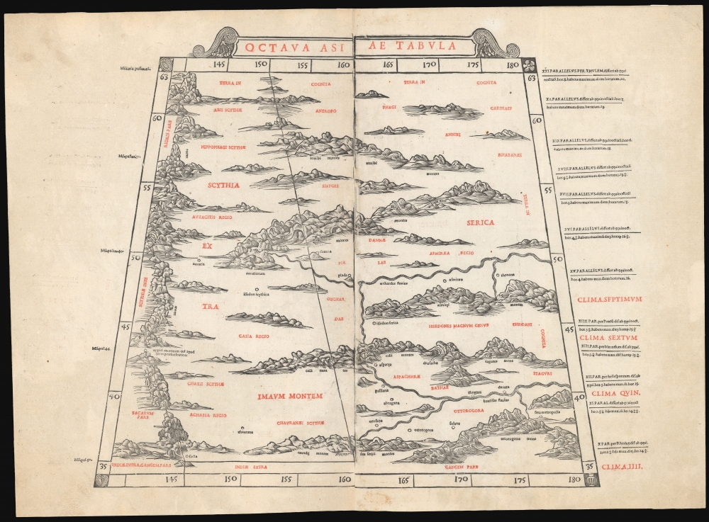
Octava Asia Tabula.
1511 (undated) 14.5 x 18 in (36.83 x 45.72 cm) 1 : 9000000
1511 (undated) 14.5 x 18 in (36.83 x 45.72 cm) 1 : 9000000
Description
This is a rare example of Bernard Sylvanus' 1511 Ptolemaic map of the eastern reaches of the Silk Road. Printed in a single edition, it is one of the most visually distinctive early woodcut maps to detail parts of modern-day Kazakhstan, Kyrgyzstan, and Tajikistan, the northeastern part of Mongolia, and the Xinjiang province of China. For Ancient Romans, this was the most remote part of the known world: Serica, named after the precious silk understood to originate there.
A Closer Look
The map is drawn on Ptolemy's trapezoidal projection, from 35° N to 63° N. The western boundary of the map is the Imaum mountains, a range that includes the Pamirs and the Hindu Kush. To the northeast are the Annibi Mountains, known today as the Altai Mountains. The central region, Issedon, is the Tarim Basin. In the southeastern corner of the map, a heavily populated region surrounds the Bautifus River, likely the upper reaches of the Yellow River. Ptolemy's information for Asia beyond the Euphrates River was a synthesis of several centuries of reports, mainly derived from journeys reaching the trade posts of the Tarim Basin, with additional verbal descriptions of the lands beyond travelers' direct experience.The Eastern Leg of the Silk Road
The western limit of this map is dominated by the Imaum Mountains. At about 43° N, this massive obstruction was passable: at this point was noted a town inhabited by ' those who set out from Sera' - Sera being the chief metropolis of Serica, the eastern terminus of the Silk Route. Sera Metropolis appears further to the southeast, near a tributary of the Bautifus (Yellow) River. Roughly between these two points, the trade posts of Issedon Scythica and Issedon Serica appear, both believed to have been located in the Tarim Basin in the modern Xinjiang province. In Ptolemy's era, the region would have been a recent conquest of Han China.An Innovative Production
This map is a woodcut printed on two sheets, each from two blocks. Sylvanus' maps are unique in that they were systematically printed in two colors, with the topography and some of the place names printed in black and additional toponymy and the cardinal directions printed in red. Although this method did not catch on among other mapmakers, it represents a milestone as one of the earliest maps printed in multiple colors. Moreover, the land masses on Sylvanus' maps display an unusual level of artistry, boldly evoking Ptolemy's imagined mountains and the many rivers snaking through them. Maps of this edition stand apart from the scantly decorated, earlier printed Ptolemies.Publication History and Census
This map is among the rarest of its kind. It was cut by Jacopo Pencio (fl. 1486 - 1530) and represents the formschneider's sole known cartographic work. It was prepared for Sylvanus' Ptolemy, printed in a single edition in 1511. We see three separate examples listed in OCLC. Fourteen examples of the complete book are listed in institutional collections.CartographerS
Bernardus Sylvanus (fl 1465-1511,) or Bernardo Silvani, was an Italian scholar and printer born in the 1460s in Eboli in southern Italy. He is thought to have lived in Naples in 1490, and to have studied Ptolemy there; he produced a manuscript edition of Ptolemy's Geographia there. In 1511 - by this time, in Venice - he published a further edition of Ptolemy's Geographia, the first to be printed in two colors, and the first Italian Ptolemy to be produced using woodblocks. There are no known works by Sylvanus after this one. More by this mapmaker...
Claudius Ptolemy (83 - 161 AD) is considered to be the father of cartography. A native of Alexandria living at the height of the Roman Empire, Ptolemy was renowned as a student of Astronomy and Geography. His work as an astronomer, as published in his Almagest, held considerable influence over western thought until Isaac Newton. His cartographic influence remains to this day. Ptolemy was the first to introduce projection techniques and to publish an atlas, the Geographiae. Ptolemy based his geographical and historical information on the "Geographiae" of Strabo, the cartographic materials assembled by Marinus of Tyre, and contemporary accounts provided by the many traders and navigators passing through Alexandria. Ptolemy's Geographiae was a groundbreaking achievement far in advance of any known pre-existent cartography, not for any accuracy in its data, but in his method. His projection of a conic portion of the globe on a grid, and his meticulous tabulation of the known cities and geographical features of his world, allowed scholars for the first time to produce a mathematical model of the world's surface. In this, Ptolemy's work provided the foundation for all mapmaking to follow. His errors in the estimation of the size of the globe (more than twenty percent too small) resulted in Columbus's fateful expedition to India in 1492.
Ptolemy's text was lost to Western Europe in the middle ages, but survived in the Arab world and was passed along to the Greek world. Although the original text almost certainly did not include maps, the instructions contained in the text of Ptolemy's Geographiae allowed the execution of such maps. When vellum and paper books became available, manuscript examples of Ptolemy began to include maps. The earliest known manuscript Geographias survive from the fourteenth century; of Ptolemies that have come down to us today are based upon the manuscript editions produced in the mid 15th century by Donnus Nicolaus Germanus, who provided the basis for all but one of the printed fifteenth century editions of the work. Learn More...
Source
Ptolemy, C. / Sylvanus, B., Liber geographiae, cum tabulis et universali figura et cum additione locorum quae a recentioribus reperta sunt, diligenti cura emendatus et impressus, (Venice) 1511.
Condition
Good. Printed to two sheets from two blocks, joined for binding. Backed with Japan paper, with few minor areas of loss reinstated in ms. Else very good.
References
OCLC 837691690. Nordenskiold, A.E., Facsimile-Atlas, pp. 18-19.