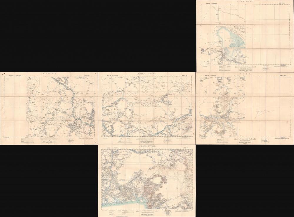
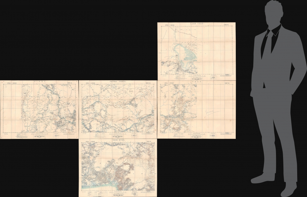
1902 War Office Five Sheet Set of Maps of Eastern Nigeria
EasternNigeria-waroffice-1902$1,500.00


Title
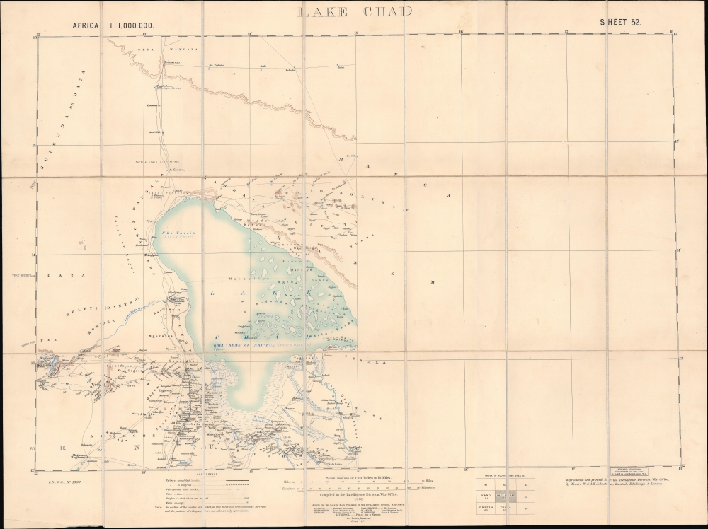
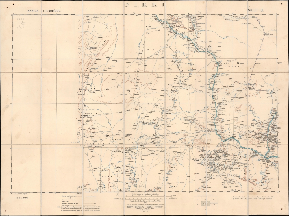
Lake Chad / Nikki / Central Nigeria. / Yola / Cross River.
1902 (dated) 21.25 x 28.5 in (53.975 x 72.39 cm) 1 : 1000000
1902 (dated) 21.25 x 28.5 in (53.975 x 72.39 cm) 1 : 1000000
Description
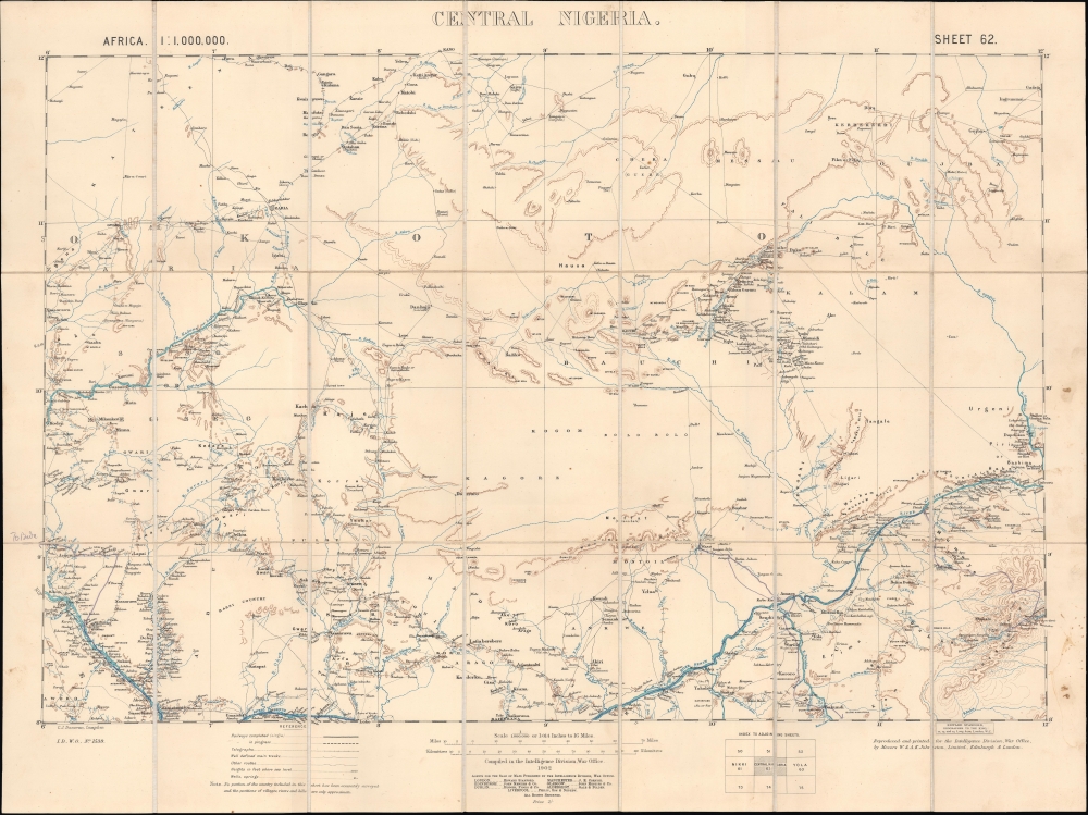
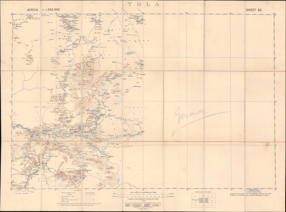
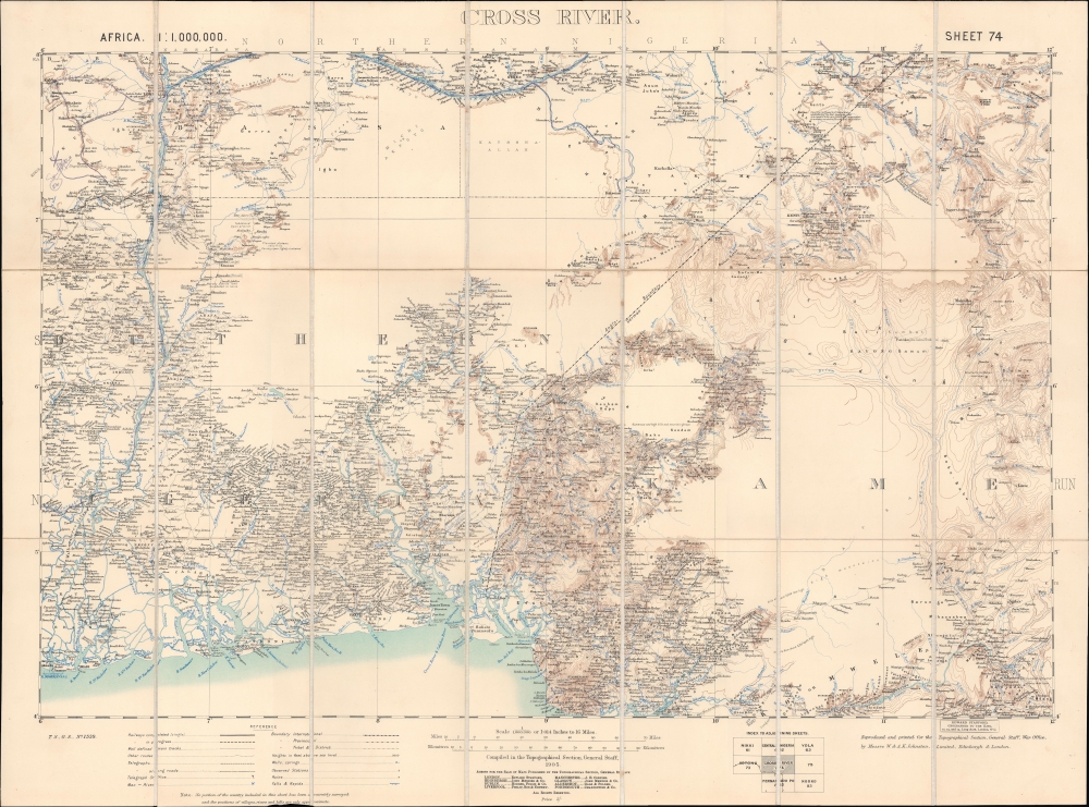
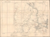
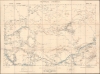
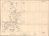
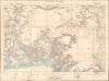
A concurrent set of five folding sheets, together forming a map covering central and eastern Nigeria, produced by the Intelligence Division of the British War Office in 1902 (with one map being dated 1905). The maps cover this region as it was roiled by opposition to British encroachments and was being negotiated over between the British and Germans, who controlled the neighboring colony of Kamerun.
Like their predecessor, these maps note settlements in remarkable detail, along with rivers (especially the Benue and Niger Rivers, which meet at Lokoja), lakes, areas of elevation, 'well defined main tracks,' other routes, wells, springs, and additional features. Notes throughout provide supplemental detail, such as 'uninhabited wilderness' or 'dense vegetation.'
Abuja, the modern capital of Nigeria, appears at left, towards bottom of the 'Central Nigeria' sheet (though the modern city is closer to Waru, slightly to the southeast of the settlement labelled Abuja here, now known as Suleja). Larger settlements towards top, especially Zaria and Kano, were well-established cities linked with trans-Saharan trading networks that in the 19th century fell to the powerful Fulani Sokoto Caliphate.
Under Crown control, the Northern and Southern Nigerian Protectorates were amalgamated as the Colony and Protectorate of Nigeria. By 1901, the Protectorate began to aggressively expand its borders, fighting in a series of wars with neighboring African kingdoms, tribal confederations, and the Sokoto Caliphate. The largest of these were the Anglo-Aro War (1901 - 1902), in the borderlands between British Nigeria and German Kamerun, and the subjugation of the Sokoto Caliphate (1900 - 1903), which faced attacks from both the British and Germans. British General Frederick Lugard (1858 - 1945), who would play a leading administrative role in Nigeria in the following decades, cleverly played rival emirs of the caliphate against each other during a relentless march into their territory. It was during this time of rapid expansion that this map was compiled - a synthesis of the most up-to-date cartographic information collected by intelligence officers, war parties, and tribal allies - as an essential tool for both conquest and administration.
A Closer Look
These sheets cover a large portion of eastern and central Nigeria, stretching from Lake Chad to the Bight of Benin and westwards beyond the Niger River to the limit of territory surveyed by the Anglo-French Boundary Commission in 1900, following an agreement between the two colonial powers to fix the border of Northern Nigeria. At right, the Anglo-German Boundary is marked, below which was the German colony of Kamerun. These sheets were an enlargement and elaboration of the 1901 map of Nigeria produced by the War Office's Intelligence Division (previously sold by us), a foundational map in the cartography of Nigeria.Like their predecessor, these maps note settlements in remarkable detail, along with rivers (especially the Benue and Niger Rivers, which meet at Lokoja), lakes, areas of elevation, 'well defined main tracks,' other routes, wells, springs, and additional features. Notes throughout provide supplemental detail, such as 'uninhabited wilderness' or 'dense vegetation.'
Abuja, the modern capital of Nigeria, appears at left, towards bottom of the 'Central Nigeria' sheet (though the modern city is closer to Waru, slightly to the southeast of the settlement labelled Abuja here, now known as Suleja). Larger settlements towards top, especially Zaria and Kano, were well-established cities linked with trans-Saharan trading networks that in the 19th century fell to the powerful Fulani Sokoto Caliphate.
British Nigeria
British colonial activity in Nigeria can be traced to 1861 when Britain annexed Lagos as part of its ongoing war against the Trans-Atlantic Slave Trade. In 1884, the Crown established the Oil River Protectorate - referring to the Niger Delta's rich production of Palm Oil. From Lagos, the British gradually expanded their influence, forcing, cajoling, and buying the loyalty of surrounding kingdoms. In the 1885 Berlin Conference, the other European colonial powers acknowledged British suzerainty over the region. The Crown founded the Royal Niger Company in 1886, granting the joint stock company a charter calling for the exploitation and development of Nigerian resources, but in the end, Nigeria proved an untenable money pit. They did, however, expand British influence southwards into the Lower Niger, driving out rival German colonials and renaming the area the Southern Nigeria Protectorate (SNP). Nonetheless, by 1900, the Royal Niger Company was in default and ceded its claims to the British Crown for £865,000.Under Crown control, the Northern and Southern Nigerian Protectorates were amalgamated as the Colony and Protectorate of Nigeria. By 1901, the Protectorate began to aggressively expand its borders, fighting in a series of wars with neighboring African kingdoms, tribal confederations, and the Sokoto Caliphate. The largest of these were the Anglo-Aro War (1901 - 1902), in the borderlands between British Nigeria and German Kamerun, and the subjugation of the Sokoto Caliphate (1900 - 1903), which faced attacks from both the British and Germans. British General Frederick Lugard (1858 - 1945), who would play a leading administrative role in Nigeria in the following decades, cleverly played rival emirs of the caliphate against each other during a relentless march into their territory. It was during this time of rapid expansion that this map was compiled - a synthesis of the most up-to-date cartographic information collected by intelligence officers, war parties, and tribal allies - as an essential tool for both conquest and administration.
Publication History and Census
These maps were prepared by the British War Office, with four of them being printed in 1902 by the office's Intelligence Division and one ('Cross River') in 1905 by the Topographical Section of the General Staff. The four Intelligence Division maps were compiled by Charles John Donovan, and all were 'reproduced and printed' by the cartographic firm W. and A.K. Johnston. Four of the maps also carry a stamp of Edward Stanford (the stamp is obscured or 'whited out' on the fifth, 'Nikki'), most likely indicating where they were sold. As mentioned above, these sheets are an enlargement and elaboration of a 1901 War Office map, the first to cover much of this territory in detail. Either as a set or individually, the maps are quite rare. We note three of the individual sheets cataloged at various institutions in the OCLC ('Central Nigeria' at Northwestern University, Nikki and Yola at the Bibliothèque nationale de France as part of a larger collection of British War Office maps of Africa from the early 20th century). The National Archives at Kew holds a collection of Nigeria maps from the early 20th century that appears to include all of these sheets.CartographerS
The British War Office (1857 - 1964) was a department of the British Government responsible for the administration of the Royal Army until 1964, when its functions were transferred to the Ministry of Defense. The War Office was to the Royal Army what the Admiralty was to the Royal Navy, and later, the Air Ministry. Within the War Office, the General Staff Topographical Section was responsible for thousands of maps issued for British intelligence and military use. The Topographical Section was renamed Geographical Section in April 1907. Many, once their military use passed, were offered through licensed agents to the general public. The sole London agent for War Office material was Edward Stanford. More by this mapmaker...
Charles John Donovan (fl. c. 1878 - 1908) was a British military draughtsman and cartographer. No information is available on his early life and training, but he joined the Ordnance Survey Department in September 1878. He then transferred to the Intelligence Division of the War Office in April 1890 and was appointed to the Permanent Staff in August 1908. The known maps ascribed to him cover different parts of Nigeria. Learn More...
Alexander Keith Johnston (December 28, 1804 - July 9, 1871) was a Scottish cartographer and map publisher active in the middle portion of the 19th century. Johnson was born at Kirkhill, near Edinburgh, Scotland. He studied at the University of Edinburgh where he apprenticed as an engraver. Around 1826, in partnership with his brother William, he founded a cartographic printing and engraving firm with the imprint "W. and A. K. Johnston." Johnston made a name for himself in educational geography, publishing numerous maps for use in schools. His brother, William Johnston, eventually left the firm to pursue a career in politics, eventually becoming the Lord Provost of Edinburgh. Alexander's son, who would bear the same name, became a geographer and explorer, suffering an untimely death on the Royal Geographical Society's 1879 expedition to Lake Nyasa. Learn More...
Edward Stanford (May 27, 1827 - November 3, 1904) was one of the most prolific map publishing firms of the late 19th century. The company began as a partnership in 1848 between the 21 year old Edward Stanford and the established map dealer Trelawney Saunders. By 1853 the partnership had dissolved and Edward Stanford took full control of the business. A subsequent series of expansions and exciting new map issues finally led to the production of Stanford's masterwork, "Stanford's Library Map of London". This map is still available and remains somewhat accurate. At the time of publishing it was hailed by the Royal Geographical Society as "the most perfect map of London that has ever been issued". In 1882 Edward Stanford Sr. passed the firm on to his son, Edward Stanford Jr. who continued in his father's proud tradition. Today the Stanford firm still publishes maps and remains one of the most important and prolific cartographic publishers in the world. Learn More...
Condition
Very good. 5 sheets of uniform size. All dissected and mounted on linen. One sheet has pinholes in all 4 corners. One sheet has some soiling.
References
OCLC 50727653, 691707159. National Archives (UK) Ref. No. CO 700/NIGERIA16.