1828 / 1849 Horsburgh Blueback Nautical Chart of Timor and Maluku Islands, Indonesia
EasternPassageChinaII-horsburgh-1849$800.00


Title
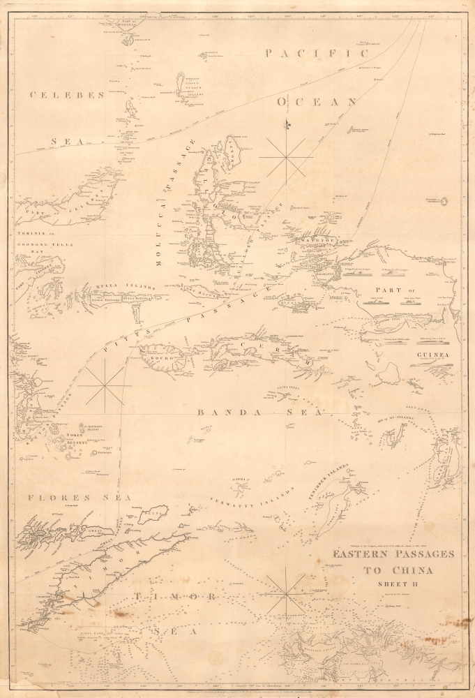
Eastern Passages to China Sheet II.
1849 (dated) 38.25 x 26 in (97.155 x 66.04 cm) 1 : 2200000
1849 (dated) 38.25 x 26 in (97.155 x 66.04 cm) 1 : 2200000
Description
A significant blueback nautical chart of a portion of the East Indies (Indonesia) including Timor, the Maluku Islands, and the Banda Sea, originally prepared in 1826 by James Horsburgh and here updated to 1849. As one of the great hydrographers of his day, Horsburgh's charts of the East Indies were among the first detailed nautical charts of these waters, providing essential information for navigators, particularly those working in the China trade.
The tradition took off in the early 19th century, when British publishers like John Hamilton Moore, Robert Blachford, James Imray, William Heather, John William Norie, Charles Wilson, David Steel, R. H. Laurie, and John Hobbs, among others, rose to dominate the chart trade. Bluebacks became so popular that the convention was embraced by chartmakers outside of England, including Americans Edmund March Blunt and George Eldridge, as well as Scandinavian, French, German, Russian, and Spanish chartmakers. Blueback charts remained popular until the late 19th century, when government subsidized organizations like the British Admiralty Hydrographic Office and the United States Coast Survey began issuing their own superior charts on high quality paper that did not require reinforcement.
A Closer Look
This chart covers a portion of the East Indies in what is now the central part of Indonesia. At the time, these waters were by no means well understood or charted, as evidenced by some speculative and blank coastlines here, making Horsburgh's work invaluable to ships transiting back and forth to southern China for trading. Including the islands of Timor, Buru, Seram, Halmahera (Gillolo), and many others in the Maluku and other nearby groups, the chart focuses primarily on the waters of the Banda Sea. Information on depths, hazards, anchorages, currents, coastal features, and other essentials for the navigator are included in great detail. The best routes through the region's straits depending on the time of year and direction of travel are traced. At right, on the western end of New Guinea, a series of small illustrated views appear, depicting, from various angles, Po. Popa, Po. Pisang, Kekik, the Lawn Isles, Fairway Rock, Xulla Bessey, and Lomblen Peak.Blueback Charts
Blueback nautical charts began appearing in London in the late 18th century. Bluebacks, as they came to be called, were privately published large format nautical charts known for their distinctive blue paper backing. The backing, a commonly available blue manila paper traditionally used by publishers to wrap unbound pamphlets, was adopted as a practical way to reinforce the low-quality paper used by private chart publishers in an effort to cut costs. That being said, not all blueback charts are literally backed with blue paper. The earliest known blueback charts include a 1760 chart issued by Mount and Page, and a 1787 chart issued by Robert Sayer.The tradition took off in the early 19th century, when British publishers like John Hamilton Moore, Robert Blachford, James Imray, William Heather, John William Norie, Charles Wilson, David Steel, R. H. Laurie, and John Hobbs, among others, rose to dominate the chart trade. Bluebacks became so popular that the convention was embraced by chartmakers outside of England, including Americans Edmund March Blunt and George Eldridge, as well as Scandinavian, French, German, Russian, and Spanish chartmakers. Blueback charts remained popular until the late 19th century, when government subsidized organizations like the British Admiralty Hydrographic Office and the United States Coast Survey began issuing their own superior charts on high quality paper that did not require reinforcement.
Publication History and Census
This chart was originally created and published by James Horsburgh in 1826, with engraving by John Bateman, and here has been updated to 1849. Cataloging of Horsburgh's 'Eastern Passages to China' chart series is somewhat inconsistent, but regardless of edition, the OCLC records examples of this chart among the institutional collections of the British Library, the National Library of Australia, the Library and Archives NT (Northern Territories), the National Library Board of Singapore, the University of California Berkeley, the University of Michicgan, the Library of Congress, and Harvard University, and it is scarce on the private market.CartographerS
James Horsburgh (September 28, 1762 – May 14, 1836) was a Scottish hydrographer and navigator active in the late 18th and early 19th century. Horsburgh was born in Fife, Elie, Scotland, to a humble family. Like many young Scottish men of little means, Horsburgh was destined for a sea-faring life and at just 16 signed on as a cabin boy in a coal trading ship. After many misadventures, including a brief incarceration by the French at Dunkirk, Horsburgh made his way to the West Indies and eventually to Calcutta, India. As the center for British maritime trade in the region, Horsburgh had no difficulty finding work with the British East India Company who maintained an active trade network between India and China. Despite the regular trade, one these voyages to China, aboard the ironically named Atlas, taught Horsburgh just how poorly the East Indies were charted. The 1786 shipwreck of the Atlas, on which he was the First Mate, near Diego Garcia Island proved a pivotal moment Horsburgh's life. He subsequently devoted himself to accurately charting the Indian Ocean and the dangerous Straits of Malacca, Sunda, and Singapore. Many of Horsburgh's charts are the direct results of his own unique survey work on board the Carron and later as captain of the Anna. Horsburgh's work culminated in the publication if his 1809 Directions for Sailing to and from the East Indies, China, New Holland, Cape of Good Hope, and the Interjacent Ports, a monumentally important guide to navigating the waters of the Indian Ocean and the East Indies. His work earned him friendships in London's highest naval and scientific circles, among them Joseph Banks and Alexander Dalrymple. He became a member of the Royal Society in 1806, when he retired from active sailing. When Alexander Dalrymple died in 1810, Horsburgh was appointed to the prestigious position of Hydrographer to the British East India Company where he worked until his death in 1836. Whereas Dalrymple was somewhat indiscriminate regarding the charts he published, Horsburgh was exacting and double checked the veracity of each and every chart that passed through his office. Horsburgh's work with the East India Company elevated the standards of the Hydrographic Department and earned him a Fellowship with the Royal Society. Today's Horsburgh's accomplishments are memorialized by the Horsburgh Lighthouse, near Singapore, and Horsburgh Island. When Horsburgh died most of his work was passed by his children to the Admiralty, which continued to publish updates until roughly 1864. More by this mapmaker...
John Bateman (fl. 1804 – 1825) was a British copperplate printer, map, and chart engraver active in London during the early part of the 19th century. Bateman is best known for his maps and charts, especially of the East Indies engraved for James Horsburgh and published between 1804 and 1825. He appears to have spent time in the East Indies with records documenting him in Calcutta as early in 1799 and may have befriended Horsburgh there. Some have speculated that John Bateman is related to Richard Bateman, another map and chart engraver active during roughly the same period. Learn More...
Condition
Good. Reinstatement lower left corner. Some Staining lower quadrants. Margin repair, lower right.
References
OCLC 19070974, 1346479486, 557224617.