1814 Thomson Map of Southeast Asia (Singapore, Thailand, Malay)
EastIndiaIsles-thomson-1814-2$450.00

Title
East India Isles.
1814 (dated) 17.5 x 21 in (44.45 x 53.34 cm) 1 : 8800000
1814 (dated) 17.5 x 21 in (44.45 x 53.34 cm) 1 : 8800000
Description
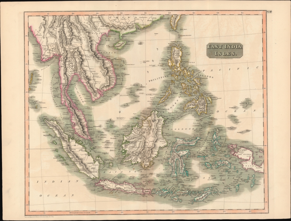
This is John Thomson's 1814 map of Southeast Asia and the East India Islands.
A Closer Look
Centered on Borneo, Thomson's map covers from China and Hainan south to Sumatra and Java, and eastward as far as the Philippines and New Guinea. Includes the Pearl River Delta at its northern most edge and names Macao and Lantao Island (Hong Kong). The Singapore Straits are identified, as are Bintan and Batam Islands, but the Island of Singapore itself is unnamed.Apocryphal Island of St. John
Just to the east of Philippine Mindanao, sets the apocryphal island of St. John's. The fiction of St. John's Island probably originates with the Portuguese cooption of manuscript mappings of this region acquired form Magellan expedition. Its first published reference is on Ortelius' 1570 Asiae Nova Descripto. Afterwards, numerous mariners, including Dampier, claimed to have visited it, however, most were most likely mistaking it for other islands in the region. Over the years the location of St. John's Island thus migrated westwards towards Mindanao's eastern coast where it resided until about 1850, when the island finally disappeared from cartographic record. In the earliest editions this map Thomson seems confident of St. John's Island, but in this edition, he annotates it with 'Doubtful'.Publication History and Census
This map is a steel plate engraving by Thomas Clerk and was prepared by John Thomson for inclusion in the 1817 edition of Thomson's New General Atlas. This is likely the 2nd edition, with the imprint of Clerk removed and minor changes made to the cartography - as noted above.CartographerS
John Thomson (1777 - c. 1841) was a Scottish cartographer, publisher, and bookbinder active in Edinburgh during the early part of the 19th century. Thomson apprenticed under Edinburgh bookbinder Robert Alison. After his apprenticeship, he briefly went into business with Abraham Thomson. Later, the two parted ways, John Thomson segueing into maps and Abraham Thomson taking over the bookbinding portion of the business. Thomson is generally one of the leading publishers in the Edinburgh school of cartography, which flourished from roughly 1800 to 1830. Thomson and his contemporaries (Pinkerton and Cary) redefined European cartography by abandoning typical 18th-century decorative elements such as elaborate title cartouches and fantastic beasts in favor of detail and accuracy. Thomson's principle works include Thomson's New General Atlas, published from 1814 to 1821, the New Classical and Historical Atlas of 1829, and his 1830 Atlas of Scotland. The Atlas of Scotland, a work of groundbreaking detail and dedication, would eventually bankrupt the Thomson firm in 1830, at which time their plates were sequestered by the court. The firm partially recovered in the subsequent year, allowing Thomson to reclaim his printing plates in 1831, but filed again for bankruptcy in 1835, at which time most of his printing plates were sold to A. K. Johnston and Company. There is some suggestion that he continued to work as a bookbinder until 1841. Today, Thomson maps are becoming increasingly rare as they are highly admired for their impressive size, vivid hand coloration, and superb detail. More by this mapmaker...
Baldwin and Cradock (fl. c. 1810 - 1860) were London based publishers working in the early to mid 19th century. They are best known for their publication of the Society for the Diffusion of Useful Knowledge's ground breaking subscription atlas. They also published John Thomson's magnificent New General Atlas from 1814 - c. 1820. In addition to their cartographic corpus, the firm had wide ranging publishing interests in many other areas, including books, broadsides, and an investment in Blackwoods Magazine. They had their offices at 47 Paternoster Row, London, England. This firm also published under the imprint Baldwin, Cradock, and Joy and Cradock and Joy. Learn More...
Source
Thomson, J., A New General Atlas, (Edinburgh: Baldwin, Cradock, Joy) 1817.
Thomson's New General Atlas was first published in 1817 and continued to be published until about 1821. This is the first of Thomson's major cartographic works and the atlas for which is most celebrated. The New General Atlas follows in the Edinburgh School, which eschews excessive decoration in favor of a more minimalistic fact-based cartographic vision, as established by John Pinkerton, Laurie and Whittle, John Cary, and others in the previous decades. The maps are notable for their massive scale, heavy stock, elegant color work, and easy-to-read typefaces. Although the atlas stopped being published after 1821, Thomson continued to offer 'supplementary' maps that could be tipped into the atlas as late as 1830, when he declared bankruptcy. The maps in the Thomson Atlas were engraved by Thomas Clerk, William Dassauville, Nathaniel Rogers Hewitt, James Kirkwood, Robert Kirkwood, John Menzies, George Menzies, Edward Mitchell, John Moffatt, Samuel John Neele, Robert Scott, and James Wyld.
Condition
Good. Some centerfold toning and offsetting.
References
Rumsey 1007.043. Phillips (Atlases) 731. Newberry Library: Ayer 135 T4 1817.