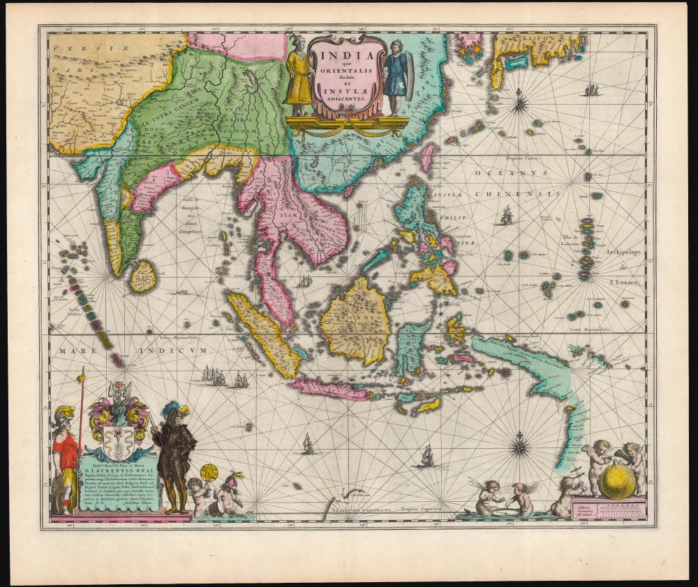
Title
India quae Orientalis dicitur, et Insulae Adiacentes.
1635 (undated)
16.25 x 19.75 in (41.275 x 50.165 cm)
1 : 19000000
Description
This is a sumptuous example of Willem Blaeu's 1635/1642 map of India, Southeast Asia, China, the Philippines, and Japan - including new information on the Philippines and Austraila. It is also among the earliest maps to depict the Philippine archipelago with any degree of precision. The map's cartographic content was engraved (probably in 1630 but as late as 1632) by Hessel Gerritsz, Blaeu's predecessor as official chartmaker for the Dutch East India Company, thus many of its features were previously suppressed, seeing public print first in this Blaeu edition.
A Closer Look
In preparing the plate for publication in his atlases, Blaeu embellished this map with his typical flair. It is beautifully engraved with eight sailing ships, a sea monster, compass roses, and rhumb lines. Its cartouches are dramatically adorned with figures and putti. The map itself, engraved by Gerritsz, reaches from the Andaman and Nicobar Islands to the Marianas (Insulae de Ladrones) and from southern China south beyond Java and Timor, thus embracing modern-day Indonesia, the Philippines, Malaysia, Thailand, Laos, and Vietnam. In the southeast, the map reveals a state-of-the-art mapping of New Guinea and northern Australia.Early Glimpses of Australia
This map is among the earliest to depict any part of Australia based on documented discovery. G. F. de Wits Land marks the 1628 site where the Dutch vessel Vianen, under Captain Gerrit Frederikszoon de Witt, ran aground. De Witt went on to chart the northwest coast of Australia about as far as present-day Port Hedland. The map also shows the lands charted in 1605-06 on the western coast of Queensland by Willem Janszoon (no relation to the mapmaker). While the Janszoon information appeared first on the 1630 Jansson map of this region (derived from Gerritsz' 1622 manuscript Mar Del Sur), Gerritsz did not pass the 1628 de Witt information to Jansson, and it did not appear on the 1630 map.
Another key contribution of Gerrtitz was from his 1627 Caert van't Landt van d'Eendracht. This appears at the bottom center, where there is a portion of the coast of Western Australia, along with the place name, 'Willems Revier.' Gerritz reported that this river had been visited by the crew of the Dutch ship Mauritius in July 1618. (The identity of this river is unknown; it may be the Ashburton River.) Further to the west, also drawn from the same source, are a small group of islands marked 'Trial.' These represent one of the earliest appearances on a map of the Tryal Rocks, so named because of the June 1622 shipwreck of the English ship Trial.The State-of-the-Art Philippines and a Phantom Island
Gerritsz's chart is also notable for its sophisticated depiction of the Philippine Archipelago. In the first part of the 17th century, European printed maps of the Philippines were overwhelmingly derived from Jan van Linschoten. Even the 1619 De Bry map - produced to accompany the account of Joris van Spilbergen's circumnavigation - did not materially improve Philippine geography. This was likely the result of protections the VOC maintained until 1619, strictly controlling the dissemination of new information relating to their sphere of operation. In that context, the depiction of the Philippines found on the present map seemed to appear out of nowhere on Jansson's 1630 map: its information originated in Gerritsz's 1622 manuscript and had not been improved upon by the end of the chartmaker's life when he engraved the present map. It retained an error that had appeared fleetingly on some earlier maps: the phantom island of St. Juan on the northeast coast of Mindanao. It appeared first on Ortelius' 1570 map of Asia, only to disappear on Linschoten's map of the region, and those maps descended from it. Lacking Gerritsz's sources, we cannot know why the official hydrographer to the VOC would include the island on his manuscript. However, on the strength of Gerritsz's work, the island appears not only here but also on subsequent maps by Dudley, Goos, Moll, and others. Dampier, in 1697, even described the island's inhabitants, flora, and fauna, so certain was he of the island's existence. Velarde's famous and authoritative 1734 map eliminated the phantom island, which might have been expected to settle the issue; indeed, many cartographers followed Velarde's model. Nevertheless, the island survived the eighteenth century in many works, including such lights as the French Bellin in 1752 and the British Laurie and Whittle in 1794. Glimpses appear even as late as 1855.China, Japan, and a Mysterious Korea
The China coast corresponds with Luis Jorge de Barbuda's place names as found on Ortelius' 1584 map. The southern Korean coast and the whole southern coast of Japan have been retained from the coasts appearing on Gerritsz's manuscripts. In this lies an astonishment: while the present work - even in its Gerritz first state - explicitly names Korea as an island, Gerritsz's 1622 Mar Del Sur clearly presented Korea as a peninsula. We are left only to speculate whether the official VOC chartmaker had simply changed his mind or whether the peninsularity of Korea was of such cartographic import that its revelation on a printed map would run against VOC interests.Proliferation of 'Thieves'
Several locations bear variations on the place name 'Ladrones.' In the southeast corner are the Insulae Ladrones, now understood as the Mariana Islands. A further I. de Ladrones appears on the southern coast of Korea, corresponding with Jeju Island. In both cases, the name is derived from the Spanish and Portuguese word for 'Thieves.' The appellation of 'Ladrones' in the Marianas dates back to Magellan's reception in Guam by the Chamorros, who boarded the ship and stole whatever could be taken. As for Korea, the archipelago, including Jeju and Tsushima, long maintained a reputation for piracy - at the least, the passive piracy of stripping wrecks. The name appears on maps of Korea going back to the 1595 Ortelius and the 1596 Linschoten, so it is unsurprising to see it surviving here.Apocryphal Lake Chiamay
The mythical Lake of Chiamay appears at the western extreme of the map, roughly in what is today Assam, India. Early cartographers postulated that such a lake must exist to source the four important Southeast Asian river systems: the Irrawaddy, the Dharla, the Chao Phraya, and the Brahmaputra. This lake appeared on maps of Asia as early as the 16th century and persisted well into the mid-18th century. Its origins are unknown but may originate in a lost 16th-century geography prepared by the Portuguese scholar Jao de Barros. It was also heavily discussed in the journals of Sven Hedin, who believed it to be associated with the Indian legend that a sacred lake, Mansarovar, linked several of the holy subcontinent river systems. There are even records that the King of Siam led an invasion force to take control of the lake in the 16th century. Nonetheless, the theory of Lake Chiamay was ultimately disproved, and it disappeared from maps entirely by the 1760s.Allegorical Decoration
The central title cartouche is flanked by soldiers in Mogul garb. In the lower left is a magnificent dedicatory cartouche to Laurens Reael (1583 - 1637), a Dutch commander, diplomat, and former Governor-General of the Dutch East Indies. Reael was instrumental in Blaeu's acquisition of Gerritsz' copper plates for this and other maps, so the dedication is directly relevant to the publication of this specific work.
The arms are surmounted by a caduceus - a symbol of commerce - but the cartouche is flanked by Athena (Goddess of Wisdom in War) and an armored warrior bearing a rod of command. At his feet are two putti, one displaying an armillary sphere while the other - wearing Ares' helmet - beats a war drum. In the lower right corner, the scales are further embellished with putti playing with navigational tools and a globe. Two more wonder at a magnetic compass. Thus, the tools of navigation and cartography are placed in the service of both war and commerce.Publication History and Census
This map was engraved as a chart by Hessel Gerritsz between 1630 and his death in 1632. When Blaeu succeeded Gerritsz as the official chartmaker to the VOC, the copperplate was purchased by Willem Blaeu with the aid of Laurens Reael. It first appeared in Blaeu's 1634 atlas in its second state, sporting a decorative engraving but lacking the dedication to Reael. The third state, including the dedication, first appeared in the 1635 Blaeu Novus Atlas and was included in all of Willem and Joan Blaeu's atlases thereafter, with no further state changes. The present example conforms typographically to examples found in Dutch editions of the Novus Atlas (1642 - 1658). Separate examples of the map are well represented in institutional collections and appear on the market from time to time.
CartographerS
Hessel Gerritsz (1581 – September 4, 1632) was a Dutch engraver, cartographer, and publisher active in Amsterdam during the late 16th and early 17th centuries, among the most preeminent Dutch geographers of the 17th century. He was born in Assum, a town in northern Holland in 1581. As a young man he relocated to Alkmaar to accept an apprenticeship with Willem Jansz Blaeu (1571-1638). He followed Blaeu to Amsterdam shortly afterwards. By 1610 he has his own press, but remained close to Blaeu, who published many of his maps. In October of 1617 he was appointed the first official cartographer of the Vereenigde Oost-Indische Compagnie (Dutch East Indian Company) or VOC. This strategic position offered him unprecedented access to the most advanced and far-reaching cartographic data of the Dutch Golden Age. Unlike many cartographers of his period, Gerritsz was more than a simple scholar and showed a true fascination with the world and eagerness to learn more of the world he was mapping in a practical manner. In 1628 he joined a voyage to the New World which resulted in the production of his seminal maps, published by Joannes de Laet in his 1630 Beschrijvinghe van West-Indien; these would be aggressively copied by both the Blaeu and Hondius houses, and long represented the standard followed in the mapping of the new world. Among his other prominent works are a world map of 1612, a 1613 map of Russia by the brilliant Russian prince Fyodor II Borisovich Godunov (1589 – 1605), a 1618 map of the pacific that includes the first mapping of Australia, and an influential 1630 map of Florida. Gerritsz died in 1632. His position with the VOC, along with many of his printing plates, were taken over by Willem Janszoon Blaeu. More by this mapmaker...
Willem Janszoon Blaeu (1571 - October 18, 1638), also known as Guillaume Blaeu and Guiljelmus Janssonius Caesius, was a Dutch cartographer, globemaker, and astronomer active in Amsterdam during the late 16th and early 17th centuries. Blaeu was born 'Willem Janszoon' in Alkmaar, North Holland to a prosperous herring packing and trading family of Dutch Reformist faith. As a young man, he was sent to Amsterdam to apprentice in the family business, but he found the herring trade dull and instead worked for his cousin 'Hooft' as a carpenter and clerk. In 1595, he traveled to the small Swedish island of Hven to study astronomy under the Danish Enlightenment polymath Tycho Brahe. For six months he studied astronomy, cartography, instrument making, globe making, and geodesy. He returned to Alkmaar in 1596 to marry and for the birth of his first son, Johannes (Joan) Blaeu (1596 – 1673). Shortly thereafter, in 1598 or 1599, he relocated his family to Amsterdam where he founded the a firm as globe and instrument makers. Many of his earliest imprints, from roughly form 1599 - 1633, bear the imprint 'Guiljelmus Janssonius Caesius' or simply 'G: Jansonius'. In 1613, Johannes Janssonius, also a mapmaker, married Elizabeth Hondius, the daughter of Willem's primary competitor Jodocus Hondius the Elder, and moved to the same neighborhood. This led to considerable confusion and may have spurred Willam Janszoon to adopt the 'Blaeu' patronym. All maps after 1633 bear the Guiljelmus Blaeu imprint. Around this time, he also began issuing separate issue nautical charts and wall maps – which as we see from Vermeer's paintings were popular with Dutch merchants as decorative items – and invented the Dutch Printing Press. As a non-Calvinist Blaeu was a persona non grata to the ruling elite and so he partnered with Hessel Gerritsz to develop his business. In 1619, Blaeu arranged for Gerritsz to be appointed official cartographer to the VOC, an extremely lucrative position that that, in the slightly more liberal environment of the 1630s, he managed to see passed to his eldest son, Johannes. In 1633, he was also appointed official cartographer of the Dutch Republic. Blaeu's most significant work is his 1635 publication of the Theatrum orbis terrarum, sive, Atlas Novus, one of the greatest atlases of all time. He died three years later, in 1638, passing the Blaeu firm on to his two sons, Cornelius (1616 - 1648) and Johannes Blaeu (September 23, 1596 - December 21, 1673). Under his sons, the firm continued to prosper until the 1672 Great Fire of Amsterdam destroyed their offices and most of their printing plates. Willem's most enduring legacy was most likely the VOC contract, which ultimately passed to Johannes' son, Johannes II, who held the position until 1617. As a hobbyist astronomer, Blaeu discovered the star now known as P. Cygni. Learn More...
Joan (Johannes) Blaeu (September 23, 1596 - December 21, 1673) was a Dutch cartographer active in the 17th century. Joan was the son of Willem Janszoon Blaeu, founder of the Blaeu firm. Like his father Willem, Johannes was born in Alkmaar, North Holland. He studied Law, attaining a doctorate, before moving to Amsterdam to join the family mapmaking business. In 1633, Willem arranged for Johannes to take over Hessel Gerritsz's position as the official chartmaker of the Dutch East India Company, although little is known of his work for that organization, which was by contract and oath secretive. What is known is his work supplying the fabulously wealthy VOC with charts was exceedingly profitable. Where other cartographers often fell into financial ruin, the Blaeu firm thrived. It was most likely those profits that allowed the firm to publish the Theatrum Orbis Terrarum, sive, Atlas Novus, their most significant and best-known publication. When Willem Blaeu died in 1638, Johannes, along with his brother Cornelius Blaeu (1616 - 1648) took over the management of the Blaeu firm. In 1662, Joan and Cornelius produced a vastly expanded and updated work, the Atlas Maior, whose handful of editions ranged from 9 to an astonishing 12 volumes. Under the brothers' capable management, the firm continued to prosper until the 1672 Great Amsterdam Fire destroyed their offices and most of their printing plates. Johannes Blaeu, witnessing the destruction of his life's work, died in despondence the following year. He is buried in the Dutch Reformist cemetery of Westerkerk. Johannes Blaeu was survived by his son, also Johannes but commonly called Joan II, who inherited the family's VOC contract, for whom he compiled maps until 1712. Learn More...
Source
Blaeu, W. / Blaeu, J., Toonneel des Aerdrycx, oft Niewe Atlas, (Amsterdam: Blaeu) 1642-1658.
The classic Dutch atlas, whose publication ushered in the Dutch golden age of cartography. Willem Jansz Blaeu had been, since 1604, producing engraved maps for sale; these were separate issues (and all consequently extremely rare) until the publishing of Blaeu's Appendix in 1630 and 1631, which also included a number of maps purchased from the widow of Jodocus Hondius, (for example his famous iteration of John Smith's map of Virginia.) In 1634, he announced his intention to produce a new world atlas in two volumes, entitled Theatrum Orbis Terrarum, sive Atlas Novus (Théâtre du Monde ou Nouvel Atlas) (in an effort to invoke the successful work of the same title produced by Ortelius the previous century, while reinforcing the notion of it being a new work.) This work was published first in German in 1634, followed by Latin, Dutch and French editions in 1635. Blaeu's maps have always been noted for the quality of their paper, engraving and fine coloring, and this was the intent from the very start. The 1634 announcement of the upcoming work described it: 'All editions on very fine paper, completely renewed with newly engraved copperplates and new, comprehensive descriptions.' (van der Krogt, p,43) Many of the most beautiful and desirable maps available to the modern collector were printed and bound in Blaeu's atlases. Willem's son, Joan, would go on to add further volumes to the Atlas Novus, concurrently printing new editions of the first two volumes with additional maps, in effect making these new editions an entirely new book. Under Joan there would be nine Latin editions, twelve French, at least seven Dutch, and two German. This exceedingly successful work would be the mainstay of the Blaeu firm until 1661, at which point the work was supplanted by Joan Blaeu's masterwork Atlas Maior in 1662.
Condition
Excellent. Original color, possibly refreshed.
References
OCLC 158732463. Rumsey 10017.618 (1665 Latin). Schilder, G. and Kok, H., Sailing for the East figure 4.18. Van der Krogt, P., Koeman's Atlantes Neerlandici, 8400:2.