
This item below is out of stock, but another example (left) is available. To view the available item, click "Details."
Details
1561 / 1574 Ruscelli Map of the East Indies and the Straits of Malacca
$450.00
1561 Ruscelli Map of the East Indies and the Straits of Malacca
EastIndies-ruscelli-1561$625.00

Title
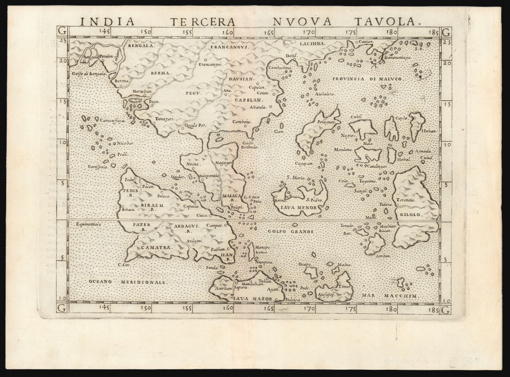
India Tercera Nuova Tavola.
1561 (undated) 7.25 x 10 in (18.415 x 25.4 cm) 1 : 30000000
1561 (undated) 7.25 x 10 in (18.415 x 25.4 cm) 1 : 30000000
Description
This is a superb example of the first state of Girolamo Ruscelli's 1561 map of the East Indies and Southeast Asia. It is among the earliest maps of Southeast Asia. Although based on Giacomo Gastaldi's 1548 map of the same title, it is roughly twice the size, and overall, a superior engraving. This was the third of the modern regional Asia maps of this edition of Ptolemy, hence 'Tercera'.
An Unknown Land
This map represents an early and necessarily flawed glimpse of newly-discovered lands. Suarez, in his Early Mapping of Southeast Asia, manages his readers' expectations:'To view the three Gastaldi maps, one must first erase from one's mind any image whatsoever of what the Philippine or Micronesian islands 'look' like; only then can one sympathize with the chaos of these Pacific incunabula.'
The Scope
The region mapped spans from the Ganges Delta to Southern China (Canton is named). Bengal, Burma (Berma), Pegu, and Cambodia (Camboia) are named. The Malay Peninsula, Malacca, Sumatra and Java are clearly noted. To the east, the first glimpses of the Philippines and the Spice Islands are recorded. The island of Ambon, visited by Antonio de Abreu in 1512, was among the targets inspiring Magellan's 1519 circumnavigation.Magellan's Philippines
The map reflects a heavy reliance on data from Magellan's voyage, which had returned in 1522 - albeit without Magellan himself, who had been killed in the Battle of Mactan the year before. The island of Magellan's first landfall in the Philippines is shown: Aguada (Homonhón in the first accounts of Magellan's voyage). Fateful Mactan (Mata) is also shown. Mindanao appears as Mendana. The map also sources from other, superior Portuguese sources. These include the relatively accurate representation of Palawan (Polaguan) and the volcanic island of Gunung Api (Ocape). This information cannot have come from Magellanic reports, but likely were known to Gastaldi from other, now unknown, Portuguese sources.Publication History and Census
This map was engraved by Giulio Sanuto for inclusion the 1561 first Ruscelli edition of Claudius Ptolemy's La Geografia di Claudio Tolomeo. The maps of this work were engraved two-to-a-plate, and consequently the platemark runs off the edge of the sheet at top. This characterizes the maps of the Latin-text editions of 1562 and 1564 as well. For the 1574 edition, the plates were cut, and maps of that edition and later exhibit a platemark all the way around. The present example corresponds to the Latin 1562 edition, both in terms of the first state of the map and the typography of the verso. In various editions there are eleven separate examples of this map listed in OCLC. Ruscelli's Ptolemy is well represented in institutional collections.CartographerS
Girolamo Ruscelli (1500 - 1566) was an Italian polymath, humanist, editor, and cartographer active in Venice during the early 16th century. Born in Viterbo, Ruscelli lived in Aquileia, Padua, Rome and Naples before relocating to Venice, where he spent much of his life. Cartographically, Ruscelli is best known for his important revision of Ptolemy's Geographia, which was published posthumously in 1574. Ruscelli, basing his work on Gastaldi's 1548 expansion of Ptolemy, added some 37 new "Ptolemaic" maps to his Italian translation of the Geographia. Ruscelli is also listed as the editor to such important works as Boccaccio's Decameron, Petrarch's verse, Ariosto's Orlando Furioso, and various other works. In addition to his well-known cartographic work many scholars associate Ruscelli with Alexius Pedemontanus, author of the popular De' Secreti del R. D. Alessio Piemontese. This well-known work, or "Book of Secrets" was a compilation of scientific and quasi-scientific medical recipes, household advice, and technical commentary on a range of topics that included metallurgy, alchemy, dyeing, perfume making. Ruscelli, as Alexius, founded a "Academy of Secrets," a group of noblemen and humanists dedicated to unearthing "forbidden" scientific knowledge. This was the first known experimental scientific society and was later imitated by a number of other groups throughout Europe, including the Accademia dei Secreti of Naples. More by this mapmaker...
Giacomo Gastaldi (c. 1500 - October, 1566) was an Italian astronomer, cartographer, and engineer active in the second half of the 16th century. Gastaldi (sometimes referred to as Jacopo or Iacobo) began his career as an engineer, serving the Venetian Republic in that capacity until the fourth decade of the sixteenth century. During this time he traveled extensively, building a large library relating to voyages and exploration. From about 1544 he turned his attention to mapmaking, working extensively with Gextantiovanni Battista Ramusio, Nicolo Bascarini, and Giovanbattista Pedrezano, as well as taking private commissions for, among others, Venice's Council of Ten. He is credited with the fresco maps of Asia and Africa still extant in the map room of the Doge's Palace. Gastaldi was also one of the first cartographers to embrace copper plate over woodblock engraving, marking an important development in the history of cartography. His 1548 edition of Ptolemy's Geographia was the first to be printed in a vernacular; it was the first to be printed in copperplate. As with his Swiss/German contemporary Münster, Gastaldi's work contained many maps depicting newly discovered regions for the first time, including the first map to focus on the East Coast of North America, and the first modern map of the Indian Peninsula. His works provided the source for the vast majority of the Venetian and Roman map publishers of the 1560s and 70s, and would continue to provide an outsize influence on the early maps of Ortelius, De Jode, and Mercator. Learn More...
Giulio Sanuto (fl. 1540 – 1580) was a Venetian engraver. He was born the illegitimate son of Cavaliere Francesco di Angelo Sanuto; With his brother, the cartographer and scientific instrument maker Livio Sanuto (1520 – 1576) he produced an array of some of the most important geographical works produced in Venice during the second half of the sixteenth century. These included a 27-inch globe and the 1588 12-sheet atlas, Geografia della Africa. Giulio's career is singluar among Venice's engraves in that it appears to have been equally based on artistic, figurative work as well as his cartographic works. Giulio is more broadly known for a small but sought-after selection of decorative engravings; no more than twelve of these can be attributed confidently to him, including the monumental Apollo and Marsyas, measuring over 1.30 meters wide. Whilst Sanuto's engravings were generally based upon the designs of other artists, his work was both ambitious and grand, and he often signed these works. Learn More...
Source
Ruscelli, G., La Geografia di Claudio Tolomeo Alessandrino…, (Venice: Vincenzo Valgrisi) 1562.
Beginning in 1561, Girolamo Ruscelli published this important, expanded edition of Giacomo Gastaldi's 1548 Ptolemy. Its maps, engraved in Venice by Giulio Sanuto, were in the main based directly upon those in Gastaldi's 1548 work. The maps were larger format than Gastaldi's, however, and Sanuto's engraving was far clearer and more legible than those appearing in the 1548 work. There are some important additions that distinguish Ruscell's Ptolemy from Gastaldi's. Ruscelli's work contained a map of the habitable world according to Ptolemy, which the Gastaldi lacked; also, the double-hemisphere map appearing in the Ruscelli was new and did not appear in the Gastaldi. Ruscelli's modern map of England was based on the work of George Lily, rather than the Waldseemüller-derived map appearing in the Gastaldi; the Ruscelli is the earliest generally acquirable map of England based on knowledge from someone who lived there. In a fateful innovation, Ruscelli's work included Septentrionalium partium nova tabula,the first copy of Nicolo Zeno's 1558 fraud Carta da Navegar, which introduced a novel mapping of the north parts of the world, including the phantom islands of Frisland, Icaria, Drogeo and Estotiland. Had Ruscelli not copied the Zeno - which had a narrow, brief publication - this preposterous geography would have probably not taken hold. Its inclusion in Ruscelli's beautiful, authoritative and popular work would lead to the adoption of the Zeno map by Mercator, Ortelius, Plancius and their successors, baffling scholars for centuries. Ruscelli's Ptolemy had a long publication history, cementing the influence of the work. It appeared both in Italian and Latin editions, all printed in Venice, throughout the latter 16th century:
- 1561 La Geographia di Claudio Tolomeo Alessandrino, Italian. Venice, Vincenzo Valgrisi.
- 1562 Geographia Cl. Ptolemaei Alexandrini, Latin. Venice, Vincenzo Valgrisi.
- 1564 La Geographia di Claudio Tolomeo Alessandrino, Italian. Venice, Giordano Ziletti.
- 1564 Geographia Cl. Ptolemaei Alexandrini, Latin. Venice, Giordano Ziletti.
- 1574 La Geographia di Claudio Tolomeo Alessandrino, Italian. Venice, Giordano Ziletti.
- 1598 Geographia di Claudio Tolomeo Alessandrino, Italian. Venice, heirs of Melchoir Sessa.
- 1599 Geographia di Claudio Tolomeo Alessandrino, Italian. Venice, heirs of Melchoir Sessa.
Condition
Excellent. Two miniscule filled wormholes, else fine.
References
OCLC: 165561277. Rumsey 11311.119 (1561 Italian) Suarez, Thomas, Early mapping of Southeast Asia, (Hong Kong: Periplus) pp. 130-157.