Digital Image: 1943 Omura Geological Map of Malaysia, Singapore, Sumatra, Borneo, Java
EastIndiesGeo-omuraichizo-1943_d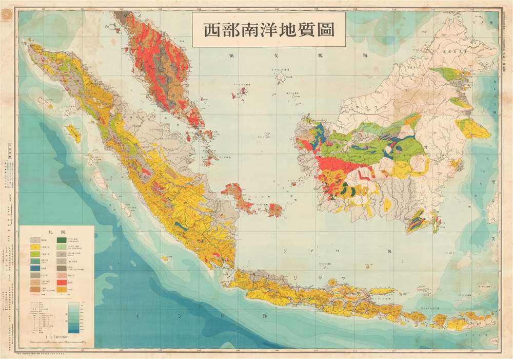

Title
西部南洋地質圖 / Western Ocean Geological Map. / Seibu nan'yō chishitsuzu.
1943 (dated) 29.5 x 42.25 in (74.93 x 107.315 cm) 1 : 2700000
1943 (dated) 29.5 x 42.25 in (74.93 x 107.315 cm) 1 : 2700000
Description
FOR THE ORIGINAL ANTIQUE MAP, WITH HISTORICAL ANALYSIS, CLICK HERE.
Digital Map Information
Geographicus maintains an archive of high-resolution rare map scans. We scan our maps at 300 DPI or higher, with newer images being 600 DPI, (either TIFF or JPEG, depending on when the scan was done) which is most cases in suitable for enlargement and printing.
Delivery
Once you purchase our digital scan service, you will receive a download link via email - usually within seconds. Digital orders are delivered as ZIP files, an industry standard file compression protocol that any computer should be able to unpack. Some of our files are very large, and can take some time to download. Most files are saved into your computer's 'Downloads' folder. All delivery is electronic. No physical product is shipped.
Credit and Scope of Use
You can use your digial image any way you want! Our digital images are unrestricted by copyright and can be used, modified, and published freely. The textual description that accompanies the original antique map is not included in the sale of digital images and remains protected by copyright. That said, we put significant care and effort into scanning and editing these maps, and we’d appreciate a credit when possible. Should you wish to credit us, please use the following credit line:
Courtesy of Geographicus Rare Antique Maps (http://www.geographicus.com).
How Large Can I Print?
In general, at 300 DPI, you should at least be able to double the size of the actual image, more so with our 600 DPI images. So, if the original was 10 x 12 inches, you can print at 20 x 24 inches, without quality loss. If your display requirements can accommodate some loss in image quality, you can make it even larger. That being said, no quality of scan will allow you to blow up at 10 x 12 inch map to wall size without significant quality loss. For more information, it is best consult a printer or reprographics specialist.
Refunds
If the high resolution image you ordered is unavailable, we will fully refund your purchase. Otherwise, digital images scans are a service, not a tangible product, and cannot be returned or refunded once the download link is used.
Cartographer S
Ōmura Ichizō (大村, 一蔵; February 15, 1884 - January 29, 1944) was a Japanese mining engineer active in Tokyo in the first half of the 20th century. Ōmura was born in Tottori Katahara 20th Mansion (now Katahara Town, Tottori City). He studied at the Tokyo Imperial Science University (Tokyo U.) graduating with a degree in Geology in 1907 (Meiji 40). His first work was with a graphite company in Shimonoseki but in 1912 (Meiji 45) he joined the Takara Oil Company in Nagaoka. He worked as an advisor to Karafuto Oil and later as director of Nippon Oil. In 1942, he became vice president of Teikoku Oil. Around this time, he also lectured at Kyushu Imperial University, Waseda University, and at Kyoto Science University. In addition to his geological work in the oil industry, he was admired as a great promoter of sports, particularly sumo wrestling and baseball, where he was active with several tournaments and championships. Ōmura died suddenly of a brain hemorrhage at just 59. More by this mapmaker...
Nihon Tōsei Chizu Kabushiki Kaisha (日本統制地圖株式會社; fl. c. 1931 - 1944) was a Tokyo-based publisher of maps of the Japanese home islands and empire. Learn More...
References
OCLC 674440249. National Diet Library, YG25-I4-1.