This item has been sold, but you can get on the Waitlist to be notified if another example becomes available, or purchase a digital scan.
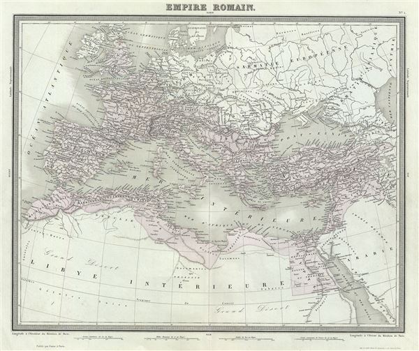
1874 Tardieu Map of the Roman Empire
EmpireRomain-tardieu-1874$62.50

Title
Empire Romain.
1874 (undated) 15 x 18 in (38.1 x 45.72 cm) 1 : 12700000
1874 (undated) 15 x 18 in (38.1 x 45.72 cm) 1 : 12700000
Description
This is a beautiful and uncommon 1874 map of the Roman Empire by Ambroise Tardieu. The map shows the extent of the Roman Empire at its height, and covers most of Europe, the Middle East, Persia and parts of North Africa including Britain, France, Egypt, the Barbary Coast, Spain, Italy and Macedonia. Throughout, the map identifies various cities, towns, rivers and assortment of additional topographical details.
The Roman Empire was established in 27 BC after Gaius Julius Caesar Octavianus, the grandnephew and heir of Julius Caesar was awarded the honorific title of Augustus. During the time of the Empire, Roman cities flourished. Trade spread as far as India, Russia, China and Southeast Asia. However, the sheer size of the Empire and its success also contributed to its downfall. The Western Roman Empire collapsed in AD 476, when Romulus Augustulus was deposed by the German Odovacer. The Eastern Roman Empire, evolving into the Byzantine Empire, survived until the Ottoman Turks captured Constantinople in 1453.
This map was prepared by Ambroise Tardieu and issued as plate no. 1 in his 1874 edition of Atlas Universel de Geographie Ancienne et Moderne.
CartographerS
Ambroise Tardieu (March 2, 1788 - January 17, 1841) was a prominent French cartographer and engraver operating in the late 18th and early 19th centuries. He was member of the large and prolific Tardieu family, which, for over 200 years, produced multiple skilled and active engravers. Tardieu's work is known for its beauty and accuracy as well as for its depth of detail. Tardieu's most important work is his version of John Arrowsmith's large format map of the United States, published in 1806. Ambroise Tardieu is eclipsed in fame by his son, artist and medical scholar, August Ambroise Tardieu. Ambroise Tardieu is also frequently confused with Jean Baptiste Pierre Tardieu, another unrelated French map and print engraver active in the early 19th century. More by this mapmaker...
Alexandre Aimé Vuillemin (1812 - 1880) was an engraver, publisher, and editor based in Paris, France in the middle of the 19th century. Despite a prolific publishing career, much of Vuillemin's life is shrouded in mystery. In 1852, he married Josephine Caroline Goret and they had at least one child, Ernestine Adèle Vuillemin, later in the same year. What is known is that his studied under the prominent French Auguste Henri Dufour (1798 - 1865). Vuillemin's most important work his detailed, highly decorative large format Atlas Illustre de Geographie Commerciale et Industrielle. Learn More...
Source
Furne, Jouvet et Cie Atlas Universel de Geographie Ancienne et Moderne (Paris), 1874.
Condition
Very good. Minor wear along original centerfold. Original platemark visible. Minor spotting.
References
Rumsey 4697.005 (1863 edition). OCLC Number: 458179945.