Digital Image: 1773 Cook Maps of the Endeavor River and Botany Bay, New South Wales, Australia
EndeavourRiverBotanyBay-cook-1773_d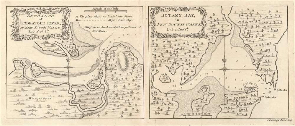

Title
Entrance of Endeavour River, in New South Wales. / Botany Bay, in New South Wales.
1773 (undated) 6.5 x 14 in (16.51 x 35.56 cm) 1 : 37000 / 1 : 149000
1773 (undated) 6.5 x 14 in (16.51 x 35.56 cm) 1 : 37000 / 1 : 149000
Description
FOR THE ORIGINAL ANTIQUE MAP, WITH HISTORICAL ANALYSIS, CLICK HERE.
Digital Map Information
Geographicus maintains an archive of high-resolution rare map scans. We scan our maps at 300 DPI or higher, with newer images being 600 DPI, (either TIFF or JPEG, depending on when the scan was done) which is most cases in suitable for enlargement and printing.
Delivery
Once you purchase our digital scan service, you will receive a download link via email - usually within seconds. Digital orders are delivered as ZIP files, an industry standard file compression protocol that any computer should be able to unpack. Some of our files are very large, and can take some time to download. Most files are saved into your computer's 'Downloads' folder. All delivery is electronic. No physical product is shipped.
Credit and Scope of Use
You can use your digial image any way you want! Our digital images are unrestricted by copyright and can be used, modified, and published freely. The textual description that accompanies the original antique map is not included in the sale of digital images and remains protected by copyright. That said, we put significant care and effort into scanning and editing these maps, and we’d appreciate a credit when possible. Should you wish to credit us, please use the following credit line:
Courtesy of Geographicus Rare Antique Maps (http://www.geographicus.com).
How Large Can I Print?
In general, at 300 DPI, you should at least be able to double the size of the actual image, more so with our 600 DPI images. So, if the original was 10 x 12 inches, you can print at 20 x 24 inches, without quality loss. If your display requirements can accommodate some loss in image quality, you can make it even larger. That being said, no quality of scan will allow you to blow up at 10 x 12 inch map to wall size without significant quality loss. For more information, it is best consult a printer or reprographics specialist.
Refunds
If the high resolution image you ordered is unavailable, we will fully refund your purchase. Otherwise, digital images scans are a service, not a tangible product, and cannot be returned or refunded once the download link is used.
Cartographer S
Captain James Cook (7 November 1728 - 14 February 1779) is a seminal figure in the history of cartography for which we can offer only a cursory treatment here. Cook began sailing as a teenager in the British Merchant Navy before joining the Royal Navy in 1755. He was posted in America for a time where he worked Samuel Holland, William Bligh, and others in the mapping of the St. Lawrence River and Newfoundland. In 1766 Cook was commissioned to explore the Pacific and given a Captaincy with command of the Endeavour. What followed were three historic voyages of discovery, the highlights of which include the first European contact with eastern Australia, the discovery of the Hawaiian Islands (among many other Polynesian groups), the first circumnavigation of New Zealand, some of the first sightings of Antarctica, the first accurate mapping of the Pacific Northwest, and ultimately his own untimely death at the hands of angry Hawaiians in 1779. The influence of Cook work on the mapping and exploration of the Pacific cannot be understated. More by this mapmaker...
John Gibson (1724 – 1773) was an English map engraver active in London at the end of the 18th century. Gibson was the son of a locksmith. In 1739 he apprenticed to John Blundell as a stationer of Grub Street. Gibson proved a fine engraver and was much in demand by London map publishers. During his career he produced thousands of maps and was admired as a skilled engraver and sculptor. Among others, he engraved for Emanuel Bowen, Robert Sayer, Jean Palairet, John Rocque, Andrew Dury, and Benjamin Martin. His best known work was prepared in conjunction with Gentleman's Magazine. Gibson, sadly, was not as astute in his fiscal affairs as with the engravers pen and consequently spent much of his life consigned to debtor's prison. Learn More...
Thomas Bowen (b. c. 1733 - March 1790) was a Welsh engraver of maps and charts. He was the son of Emanuel Bowen (1693/4–1767), under whom he had apprenticed. His work was printed with his father's, as well as other publishers throughout the latter half of the eighteenth century. He married Alice Downes on December 25, 1768. He appears even thento have not been successful, and more than once found himself a debtor. He was imprisoned for debt in 1761, and he met his death in 1790 in Clerkenwell workhouse. Learn More...
References
Rumsey 3403.047. OCLC 53453596.