This item has been sold, but you can get on the Waitlist to be notified if another example becomes available, or purchase a digital scan.
1804 Knight / Penelope Steel Blueback Chart or Map of the English Channel
EnglishChannel-knightsteel-1804$1,500.00

Title
A Chart of the British Channel, On Mercator's Projection.
1804 (dated) 37.5 x 72 in (95.25 x 182.88 cm) 1 : 550000
1804 (dated) 37.5 x 72 in (95.25 x 182.88 cm) 1 : 550000
Description
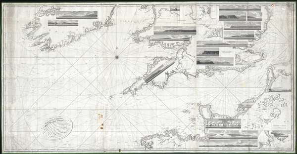
This is a first edition of Penelope Steel's magnificent 1804 nautical chart or maritime map of the English Channel. This is one of the few blueback charts published by a woman bearing a woman's imprint – in this case, Penelope Steel, the widow of David Steel. Based upon the c. 1802 survey work of Captain John Steel, one of the first surveys of the English Channel to be completed with the newly invented 'H5' marine chronometer.
The map's coverage extends from the western shores of Ireland to the coasts of France, including the English Channel, Bristol Channel, and part of St. Georges Channel. The chart further includes 18 shore profile views and inset maps of Mount's Bay, Portsmouth Harbor, the western part of the Isle of Wight, Portland Harbor, Sheerness, Exmouth Bar, Dartmouth, St. Vincent's Passage, and the Scilly Isles.
The map's coverage extends from the western shores of Ireland to the coasts of France, including the English Channel, Bristol Channel, and part of St. Georges Channel. The chart further includes 18 shore profile views and inset maps of Mount's Bay, Portsmouth Harbor, the western part of the Isle of Wight, Portland Harbor, Sheerness, Exmouth Bar, Dartmouth, St. Vincent's Passage, and the Scilly Isles.
Blueback Charts
Blueback nautical charts began appearing in London in the late 18th century. Bluebacks, as they came to be called, were privately published large format nautical charts known for their distinctive blue paper backing. The backing, a commonly available blue manila paper traditionally used by publishers to warp unbound pamphlets, was adopted as a practical way to reinforce the low-quality paper used by private chart publishers in an effort to cut costs. The earliest known blueback charts include a 1760 chart issued by Mount and Page, and a 1787 chart issued by Robert Sayer. The tradition took off in the early 19th century, when British publishers like John Hamilton Moore, Robert Blachford, James Imray, William Heather, John William Norie, Charles Wilson, David Steel, R. H. Laurie, and John Hobbs, among others, rose to dominate the chart trade. Bluebacks became so popular that the convention was embraced by chartmakers outside of England, including Americans Edmund March Blunt and George Eldridge, as well as Scandinavian, French, German, Russian, and Spanish chartmakers. Blueback charts remained popular until the late 19th century, when government subsidized organizations like the British Admiralty Hydrographic Office and the United States Coast Survey, began issuing their own superior charts on high quality paper that did not require reinforcement.Publication History and Census
This nautical chart is derived from the survey work of Captain John Knight. Knight achieved the Rank of Rear Admiral, as noted on the chart, in 1801, so the cartographic work behind this chart was probably completed in 1802 or 1803. This map was published by Penelope Steel, the widow of the noted early blueback chartmaker, David Steel the Younger, who died at just 39 in 1803. It is not inconceivable that D. Steel may have worked on the map, but the imprint of his widow, P. Steel, is unmistakable.CartographerS
David Steel, Senior (1734 - 1799) was a British chart publisher, engraver, instrument-seller, bookseller, bookbinder, and vendor of patent medicines. The son of a William Steel, a bookbinder, he apprenticed in the firm founded by Mount and Page. He married Ann Beauchamp in 1776. He began publishing nautical charts in 1782. His business was founded on the publication of his own technical nautical works and the list of the Royal Navy. The firm owned a navigation warehouse and opened a navigation school in 1799. Following his father’s death, David Steel, Junior (1763 - 1803) took over the family business until his untimely death at the age of 39. Steel, Junior, first began working at the Navy Office, before leaving that position to study law. He worked a a practicing barrister for several years, until the death of his father. David married Penelope Winde on May 1, 1786. They had five children together. An obituary for David Steel, Junior, in the Steel publication Navy List states that 'of his character it may be said, that his ideas were most enlarged, his mind capacious and richly cultivated; his principles generous and manly; his eloquence nervous and impressive.' After David Steel Junior's untimely death, his wife Penelope took over the family business, and marries William Mason in 1806, with whom she continued the business. She moved the firm to 70 Cornhill in 1809 from Union Row, Tower Hill. By 1810 the supply of new charts had ceased, and John Purdy, who had apprenticed with David Steel, Senior, left the firm to work with Laurie and Whittle, the Steel's competitors. By 1814, Penelope Steel had entered into a business partnership with Stanley Goddard, a younger man, who would become her third husband, and renamed the firm Steel and Goddard. By June 1819, Goddard and the firm were bankrupt, and J. W. Norie and Company acquired the 'case fixtures, stock in trade and copper plates' from the firm. More by this mapmaker...
John Knight (February 21, 1747 - June 16, 1831) was a Scottish naval officer and marine surveyor active in England in the late 18th and early 19th centuries. Knight was born in Dundee, Scotland. He was the son of a well-respected British Navy Rear Admiral, also named John Knight. At just 11 years old, he joined the Royal Navy serving under his father during the Seven Years War. After the war, he assisted Joseph Frederick Wallet DesBarres surveying the northeastern coasts of America before returning to Europe. In 1775, just prior to the outbreak of the American Revolutionary War, he returned to the Americas, now a Lieutenant where he served on the HMS Falcon. He was in Boston during the Battle of Bunker Hill and in 1776 was captured by an American Schooner. After a prisoner exchange he returned to British naval service in command of the independent hired vessel, the HMS Haerlem, with which he raided the American eastern seaboard. Around this time Knight met his wife, Prudence Reynolds, who he met and married in America and with whom he had eight children and maintained an extremely close relationship despite extended navy tours of duty. In 1780, onboard the HMS Barfleur with young Prince William Henry (William IV), who performed the duties of a Midshipman, he participated in the Battle of Fort Royal and the Battle of the Chesapeake. After the war he remained in command of the HMS Barfleur, where he was given the responsibility of educating William, who also remained with the ship, in maritime matters. He served in various posts throughout the French Revolutionary Wars and conducted an important survey of the English Channel – the first to use the newly invented Marine Chronometer. In 1801, Knight was promoted to rear-admiral, and in 1805, during the Napoleonic Wars, he was named as commander at Gibraltar, where he remained for another ten years until the war's end. He retired from the British Navy as a full admiral and a Knight Commander of the Order of the Bath. After retirement he settled with his family at Woodend House in Soberton, Hampshire, and died there in June 1831. Although he was respected professionally, Knight was unpopular with his crew and with fellow officers. His commands were known for lax discipline and he was resented by his crew for frequently brining wife and children to sea. Learn More...
Condition
Good. Some soiling. Margin tears. Professionally repacked with fresh blueback paper and re-edged.
References
New York Public Library, Map Division, Map Div. 11-426. OCLC 71416402.