This copy is copyright protected.
Copyright © 2025 Geographicus Rare Antique Maps
Digital Image: 1695 Morden and Harris Map of the English Empire in America
EnglishEmpireinAmerica-morden-1695_d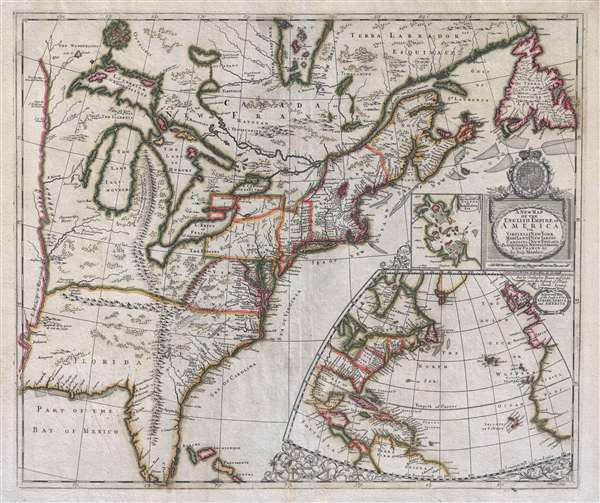

FOR THE ORIGINAL ANTIQUE MAP, WITH HISTORICAL ANALYSIS, CLICK HERE.
Digital Map Information
Geographicus maintains an archive of high-resolution rare map scans. We scan our maps at 300 DPI or higher, with newer images being 600 DPI, (either TIFF or JPEG, depending on when the scan was done) which is most cases in suitable for enlargement and printing.
Delivery
Once you purchase our digital scan service, you will receive a download link via email - usually within seconds. Digital orders are delivered as ZIP files, an industry standard file compression protocol that any computer should be able to unpack. Some of our files are very large, and can take some time to download. Most files are saved into your computer's 'Downloads' folder. All delivery is electronic. No physical product is shipped.
Credit and Scope of Use
You can use your digial image any way you want! Our digital images are unrestricted by copyright and can be used, modified, and published freely. The textual description that accompanies the original antique map is not included in the sale of digital images and remains protected by copyright. That said, we put significant care and effort into scanning and editing these maps, and we’d appreciate a credit when possible. Should you wish to credit us, please use the following credit line:
Courtesy of Geographicus Rare Antique Maps (http://www.geographicus.com).
How Large Can I Print?
In general, at 300 DPI, you should at least be able to double the size of the actual image, more so with our 600 DPI images. So, if the original was 10 x 12 inches, you can print at 20 x 24 inches, without quality loss. If your display requirements can accommodate some loss in image quality, you can make it even larger. That being said, no quality of scan will allow you to blow up at 10 x 12 inch map to wall size without significant quality loss. For more information, it is best consult a printer or reprographics specialist.
Refunds
If the high resolution image you ordered is unavailable, we will fully refund your purchase. Otherwise, digital images scans are a service, not a tangible product, and cannot be returned or refunded once the download link is used.
Robert Morden (c. 1650 – 1703) was an English bookseller, publisher, globe maker, and mapmaker active in London on the second half of the 17th century. He is notable as one of the first successful commercial map publishers. Morden was most likely born in the north of England. As a young map he apprenticed to Joseph Moxon. He published a wide corpus of maps, most which focused on the British Isles, but also included important early maps of Britain's colonial holdings. Morden frequently partnered with William Berry and Christopher Browne. He maintained offices at the Signe of the Atlases in Cornhill and New Cheapside, London. More by this mapmaker...
Christopher Browne (fl. c. 1688 – 1712) was a British map seller, book seller, and publisher active in the late 17th and early 18th centuries. Browne apprenticed with Robert Walton whose business he took over in 1688. Little is known of Browne's life but he issued several maps in concert with the Overtons, Herman Moll, and Robert Morden. Brown appears to have retired in 1712, relocating to Chilthorne Domer, a picturesque village in Somerset, England. According to Worms and Baynton-Williams he was still alive as of 1737. Learn More...
John Harris (fl. 1686 – 1730) was a British cartographer, engraver and draughtsman active in London during the late 17th and early 18th centuries. Harris is believed to have been born in Northamponshire but little else is certain regarding his personal life as 'John Harris' was an exceedingly common name be 17th century London. Nonetheless, his known work includes engravings for Philip Lea, Robert Morden, Herman Moll, and others. Learn More...
Copyright © 2025 Geographicus Rare Antique Maps | Geographicus Rare Antique Maps
This copy is copyright protected.
Copyright © 2025 Geographicus Rare Antique Maps