This copy is copyright protected.
Copyright © 2025 Geographicus Rare Antique Maps
Digital Image: 1892 G. Lang Wall Map of the World on Mercator Projection
Erdkarte-lang-1892_d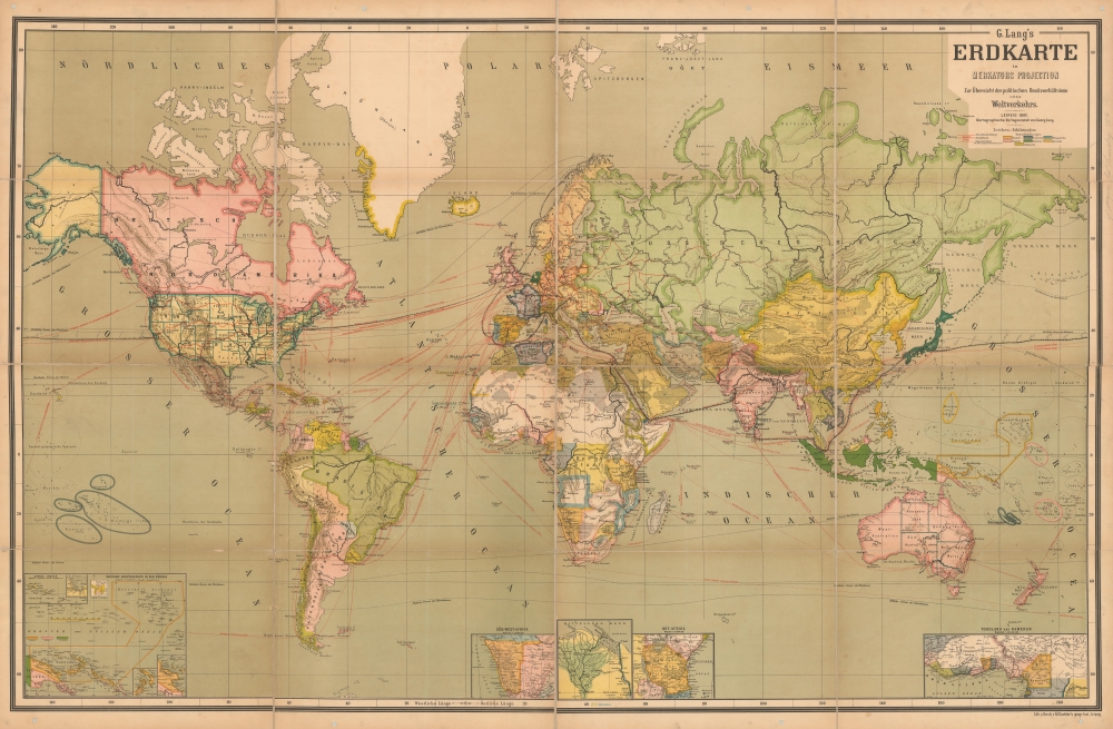

FOR THE ORIGINAL ANTIQUE MAP, WITH HISTORICAL ANALYSIS, CLICK HERE.
Digital Map Information
Geographicus maintains an archive of high-resolution rare map scans. We scan our maps at 300 DPI or higher, with newer images being 600 DPI, (either TIFF or JPEG, depending on when the scan was done) which is most cases in suitable for enlargement and printing.
Delivery
Once you purchase our digital scan service, you will receive a download link via email - usually within seconds. Digital orders are delivered as ZIP files, an industry standard file compression protocol that any computer should be able to unpack. Some of our files are very large, and can take some time to download. Most files are saved into your computer's 'Downloads' folder. All delivery is electronic. No physical product is shipped.
Credit and Scope of Use
You can use your digial image any way you want! Our digital images are unrestricted by copyright and can be used, modified, and published freely. The textual description that accompanies the original antique map is not included in the sale of digital images and remains protected by copyright. That said, we put significant care and effort into scanning and editing these maps, and we’d appreciate a credit when possible. Should you wish to credit us, please use the following credit line:
Courtesy of Geographicus Rare Antique Maps (http://www.geographicus.com).
How Large Can I Print?
In general, at 300 DPI, you should at least be able to double the size of the actual image, more so with our 600 DPI images. So, if the original was 10 x 12 inches, you can print at 20 x 24 inches, without quality loss. If your display requirements can accommodate some loss in image quality, you can make it even larger. That being said, no quality of scan will allow you to blow up at 10 x 12 inch map to wall size without significant quality loss. For more information, it is best consult a printer or reprographics specialist.
Refunds
If the high resolution image you ordered is unavailable, we will fully refund your purchase. Otherwise, digital images scans are a service, not a tangible product, and cannot be returned or refunded once the download link is used.
Georg Lang (f. 1892 - 1949) was a German map publisher active in Leipzig in the late 19th and first half of the 20th centuries. He is known for his impressive wall maps and diagrams published for schoolroom and general educational use. Lang exhibited along with Justus Perthes and Carl Flemming at the German Publisher booth at the 1893 Chicago Columbian Exposition. His cartographic work is often associated with the cartographer Eduard Gaebler (1842 - 1911). At some point he became associated with Hilmar Klasing and Co., a major cartographic firm. More by this mapmaker...
Friedrich Eduard Gaebler (January 22, 1842 - November 8, 1911) was a German cartographer, engraver, publisher and lithographer based in Leipzig. Gabler was born in Pegau, Saxony, Germany. After receiving a basic education, he produced to master engraving and mapmaking at the Leipzig school of Albert Henry Payne. He worked with his brother, Rober Gaebler to develop a zincography-based pantatype printing process ideal for map work. In 1866 he established an institute for geographic studies, which he managed until 1874, when he took over George Westermann's (1810 - 1879) geographical institute. Westermann died in 1879 and Gaebler took over his geographical business, founding Eduard Gaeblers Geographisches Institut on December 5, 1879. He became successful providing top quality engraving and geographical work for a variety of publishers including Georg Lang and Carl Kiercke. When he died in 1911, the firm was taken over by his sons and remained active until 1935, when it declared bankruptcy. In 1941, the remains of the firm were acquired by the Deutschen Zentraldruckerei AG, which itself shut down in 1945. Learn More...
Copyright © 2025 Geographicus Rare Antique Maps | Geographicus Rare Antique Maps
This copy is copyright protected.
Copyright © 2025 Geographicus Rare Antique Maps