This item has been sold, but you can get on the Waitlist to be notified if another example becomes available, or purchase a digital scan.
1813 Arrowsmith 'Great Game' Map of Iran and Afghanistan, Iraq, and Pakistan
EuphratesIndus-arrowsmith-1813
Title
1813 (dated) 37.5 x 50.5 in (95.25 x 128.27 cm) 1 : 2500000
Description
A Closer Look
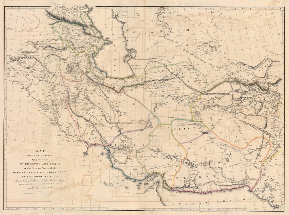
The map is derived from first-hand reconnaissance and cartographic materials gathered by Sir John Malcolm and John Macdonald Kinneir. Coverage embraces from the Black Sea to Kashgar and Yarkand, incorporating parts of modern-day western China, and from Georgievsk in the Caucasus Mountains in Russia to the Indian Ocean. As the title suggests, the region's river system is key to this map - and to the region. It highlights the Tigris, Euphrates, Indus, and the Amu Darya (Oxus) rivers and their tributaries. The map's large size allows for a detailed study of the regional road network - including major hubs, wells, daily stopping posts, smaller towns, and more.Franco-Persian Relations and Sir John Malcolm's 1808 Mission to Persia
The French had been courting the Persians since 1806 when the British allied with Russia to create the Third Coalition against Napoleonic France. Russia had been fighting the Russo-Persian War (1804 - 1813), making any British alliance with Persia impossible. The French supported the Persian government and encouraged a Persian invasion of India, even equipping and training the Persian army. Then, in 1808, France and Russia signed the Treaty of Tilsit, which brought Russia onto the French side of the Napoleonic Wars, isolated Britain, and ended all assistance and support the French had been providing to Persia.The abrupt change in international alliances opened the door for the British to foster a deeper relationship with Persia. They sent Major General Sir John Malcolm (1769 - 1833), a Scottish soldier, statesman, diplomat, historian, and East India Company administrator. He undertook three missions to Persia in 1801, 1808, and 1810. The 1808 mission was a complete failure - since the British had been expecting a French-sponsored invasion of India from Persia, the British government and the East India Company were hostile toward the Persians. They dispatched a fleet from the East Indies to transport Malcolm and his entourage to Persia. In an effort at gunboat diplomacy, the fleet was to blockade the coast and threaten invasion. In this case, it was a bluff. In the face of the ongoing Napoleonic Wars (1803 - 1815), the British could not simultaneously protect the China Trade, invade Persia, and contain French aggression in Europe. The Shah called Britain's bluff and refused even to see Malcolm. Malcolm returned to India, having accomplished nothing.
Sir John Macdonald Kinneir
Sir John Macdonald Kinneir began his association with Asia in 1804 when he was assigned to the Madras infantry as an ensign. His travels throughout Asia began with Sir John Malcolm's mission to Persia in 1808-09, during which Kinneir was supernumerary agent. From 1810, he traveled from Baghdad to Constantinople, stopping at Mosul, Manisa, and Smyrna. He returned to Britain from Constantinople via Spain and Portugal. While in Britain, he wrote A Geographical Memoir of the Persian Empire, Accompanied by a Map (this map). He was ordered to return to India in 1813 and initially went to Stockholm, expecting to travel via Russia and Persia due to the continuing Napoleonic Wars. However, because Napoleon retreated from Moscow, the southern route opened, and so traveled from Stockholm through Poland, Austria, and Hungary before reaching Constantinople again and continuing through Armenia, Kurdistan, and Baghdad to Bombay (Mumbai). Kinneir returned to Persia in 1824 as an East India Company envoy. Kinneir stayed in Persia until he died in Tabriz on June 11, 1830.The Great Game
'The Great Game' was a diplomatic confrontation between the British and Russian Empires over Afghanistan and other territories in Central and Southern Asia. There is considerable debate as to when the Great Game began, but it was most likely the 1813 Treaty of Gulistan between Russia and Persia, which ended the Russo-Persian War (1804 - 1813), opened Persia to further Russian intervention, and set Russian and British regional interests at odds. The conflict, rooted in long-standing animosity between Russia and Britain, revolved around Afghanistan, which, while lacking significant resources of its own, was strategically situated. For its part, Russia feared Britain was making commercial and military inroads into Central Asia, an area long within the sphere of influence of St. Petersburg. Britain, conversely, feared Russia making gains in India, 'the jewel in the crown' of British Asia. The escalating tensions led to several wars and proxy wars: The First Anglo-Afghan War (1839 - 1842), the First Anglo-Sikh War (1845 - 1846), the Second Anglo-Sikh War (1848 - 1849), and the Second Anglo-Afghan War (1878 - 1880), along with the Russian annexations of Khiva, Bukhara, and Kokand. Then, as now, Afghanistan proved a grinding stone upon which the world's great empires diminished themselves, none achieving a definitive victory despite committing staggering resources. The Great Game 'ended' on September 10, 1895, with the signing of the Pamir Boundary Commission Protocols, which stabilized the border between Afghanistan and the Russian Empire - but in truth, the conflict persisted well into the 20th century. Regarding the attitude of Afghans toward the British and Russians, the general assumption of the British was that 'Some will fight for us, some against us, but all will fight.'Publication History and Census
This map was compiled by John Macdonald Kinneir and published by John Arrowsmith to accompany Kinneir's book A Geographical Memoir of the Persian Empire, Accompanied by a Map, which Kinneir wrote after taking part in Sir John Malcolm's failed 1808 mission to Persia. This is the first edition; a later edition was published in the 1850s by the Calcutta Surveyor General's Office for use during the Anglo-Persian War (1856 - 1857). We note 7 examples of this edition in OCLC: the Metropolitan Museum of Art, Harvard University, the Charleston Library Society, the University of Exeter, Leiden University, the Württembergische Landesbibliothek, and the Bayerische Staatsbibliothek.CartographerS
Aaron Arrowsmith (1750-1823), John Arrowsmith (1790-1873), and Samuel Arrowsmith. The Arrowsmith family were noted map engravers, publishers, geographers, and cartographers active in the late 18th and early 19th century. The Arrowsmith firm was founded by Aaron Arrowsmith, who was trained in surveying and engraving under John Cary and William Faden. Arrowsmith founded the Arrowsmith firm as a side business while employed by Cary. The firm specialized in large format individual issue maps containing the most up to date and sophisticated information available. Arrowsmith's work drew the attention of the Prince of Wales who, in 1810, named him Hydrographer to the Prince of Wales, and subsequently, in 1820, Hydrographer to the King. Aaron Arrowsmith was succeeded by two sons, Aaron and Samuel, who followed him in the map publication business. The Arrowsmith firm eventually fell to John Arrowsmith (1790-1873), nephew of the elder Aaron. John was a founding member of the Royal Geographical Society. The firm is best known for their phenomenal large format mappings of North America. Mount Arrowsmith, situated east of Port Alberni on Vancouver Island, British Columbia, is named for Aaron Arrowsmith and his nephew John Arrowsmith. More by this mapmaker...
Sir John Macdonald Kinneir (February 3, 1782 - June 11, 1830) was a Scottish army officer of the East India Company, diplomat and traveller. In 1804 he was appointed ensign in the Madras infantry, and posted in 1807 as lieutenant. He was attached to Sir John Malcolm's mission in Persia between 1808–9, during which time he travelled widely. He produced a Gazetteer of Persia in 1813, which for many years remained the best source of geographical data for that part of the world. In 1824 he was appointed envoy to Fath-Ali Shah Qajar of Persia, for the East India Company, arriving in time for the Russo-Persian War (1826–28). Learn More...


