This item has been sold, but you can get on the Waitlist to be notified if another example becomes available, or purchase a digital scan.
1617 / 1634 Willem Blaeu Carte-a-Figures of Europe
Europe-blaeu-1617
Title
1617 (undated) 16 x 21.75 in (40.64 x 55.245 cm) 1 : 14650000
Description
A Closer Look
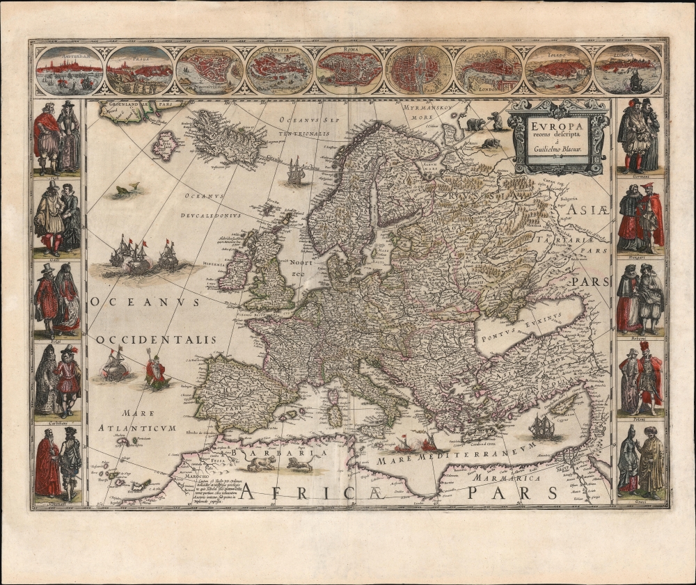
The map presents Europe but reaches as far south as North Africa, thus including the Mediterranean Sea and the Lower Nile. It further includes the Canary Islands in the southwest, a glimpse of the Red Sea in the southeast, and southern Greenland in the northwest. The elegant cartouche occupies the upper right, whose detail in that quadrant diminishes beyond the Volga River. The map extends just beyond the Arctic Circle.The East
The map extends to the Volga River and the Dvina River and thus encompasses Muscovy and Russia, beyond which lies Tartaria and Asia. Lithuania is bounded with an engraved dotted line as well as a highlighting border in original color. Kiovia and present-day Ukraine within those bounds and thus not part of Tartaria or Muscovy. The Ottoman Empire extends well into Greece and the Balkans.The North
Blaeu's Scandinavia is state-of-the-art and reflects the knowledge of Anders Bure (1571 - 1646). His treatment of Iceland, too, reflects the understanding of that island that had first exploded in European cartography with Ortelius' publication of the map of Guðbrandur Þorláksson (1542 - 1627.) However, it also includes the phantom island of Frisland, a tenacious remnant of the 1558 fraud inflicted on European cartography by Nicoló Zeno the Younger (1515 - 1565).Carte-á-figures Surround
Although other Dutch mapmakers (Hondius, Jansson, and van der Keere, for example) also produced such maps, maps of Blaeu in this form are justifiably well known and prized. Generally, this grand treatment was reserved for maps of the continents - these large-scale, general maps were showcases for the mapmaker's art. This was the case here: indeed, the privilege in the lower left prohibits the copying of 'these tables of the four parts of the world,' reflecting the intention of the author that the four be considered a set. Often, such maps were separate issues or intended for larger, deluxe editions of their respective atlases. For the Hondius' atlas, for instance, the borders tended to be absent in the continent maps to permit the use of smaller folio sheets and waste less margin space throughout the rest of the book. Blaeu's lavish atlases, sporting large sheets and broad borders, were intended to beautifully showcase maps such as this. The city views along the top - Amsterdam, Prague, Constantinople, Venice, Rome, Paris, London, Toledo, and Lisbon - were, for the most part, derived from the respective sheets in the Braun and Hogenberg Civitatis Orbis Terrarum. The left and right borders display noblemen and women of England, France, the Netherlands, Castille, Germany, Hungary, Bohemia, Poland, and Greece. The panel for Venice seems to break the theme, depicting instead the Doge and a courtier.Publication History and Census
This map was engraved in 1617 along with similarly-styled cartes à figures of the other continents; they were very likely sold as sets. The map is recorded in three states. The virtually unacquirable first state was dated and bore Blaeu's imprint 'Guiliel. Janssonio,' prior to Jan Jansson's establishment as a next-door competitor. The present example is the map's second state, lacking a date and bearing the new 'Guilielmo Blaeuw' imprint. It, too, may have enjoyed a separate issue but made its first bound appearance in the 1630 Appendix. Our example appeared in the 1634 German text edition of the Blaeu Novus Atlas. A third state was produced by Joan Blaeu in 1660, eliminating the phantom island of Frisland. The map appears on the market from time to time and is well-represented in institutional collections.Cartographer
Willem Janszoon Blaeu (1571 - October 18, 1638), also known as Guillaume Blaeu and Guiljelmus Janssonius Caesius, was a Dutch cartographer, globemaker, and astronomer active in Amsterdam during the late 16th and early 17th centuries. Blaeu was born 'Willem Janszoon' in Alkmaar, North Holland to a prosperous herring packing and trading family of Dutch Reformist faith. As a young man, he was sent to Amsterdam to apprentice in the family business, but he found the herring trade dull and instead worked for his cousin 'Hooft' as a carpenter and clerk. In 1595, he traveled to the small Swedish island of Hven to study astronomy under the Danish Enlightenment polymath Tycho Brahe. For six months he studied astronomy, cartography, instrument making, globe making, and geodesy. He returned to Alkmaar in 1596 to marry and for the birth of his first son, Johannes (Joan) Blaeu (1596 – 1673). Shortly thereafter, in 1598 or 1599, he relocated his family to Amsterdam where he founded the a firm as globe and instrument makers. Many of his earliest imprints, from roughly form 1599 - 1633, bear the imprint 'Guiljelmus Janssonius Caesius' or simply 'G: Jansonius'. In 1613, Johannes Janssonius, also a mapmaker, married Elizabeth Hondius, the daughter of Willem's primary competitor Jodocus Hondius the Elder, and moved to the same neighborhood. This led to considerable confusion and may have spurred Willam Janszoon to adopt the 'Blaeu' patronym. All maps after 1633 bear the Guiljelmus Blaeu imprint. Around this time, he also began issuing separate issue nautical charts and wall maps – which as we see from Vermeer's paintings were popular with Dutch merchants as decorative items – and invented the Dutch Printing Press. As a non-Calvinist Blaeu was a persona non grata to the ruling elite and so he partnered with Hessel Gerritsz to develop his business. In 1619, Blaeu arranged for Gerritsz to be appointed official cartographer to the VOC, an extremely lucrative position that that, in the slightly more liberal environment of the 1630s, he managed to see passed to his eldest son, Johannes. In 1633, he was also appointed official cartographer of the Dutch Republic. Blaeu's most significant work is his 1635 publication of the Theatrum orbis terrarum, sive, Atlas Novus, one of the greatest atlases of all time. He died three years later, in 1638, passing the Blaeu firm on to his two sons, Cornelius (1616 - 1648) and Johannes Blaeu (September 23, 1596 - December 21, 1673). Under his sons, the firm continued to prosper until the 1672 Great Fire of Amsterdam destroyed their offices and most of their printing plates. Willem's most enduring legacy was most likely the VOC contract, which ultimately passed to Johannes' son, Johannes II, who held the position until 1617. As a hobbyist astronomer, Blaeu discovered the star now known as P. Cygni. More by this mapmaker...


