1593 Cornelis De Jode Map of Europe
Europe-dejode-1593$10,000.00

Title
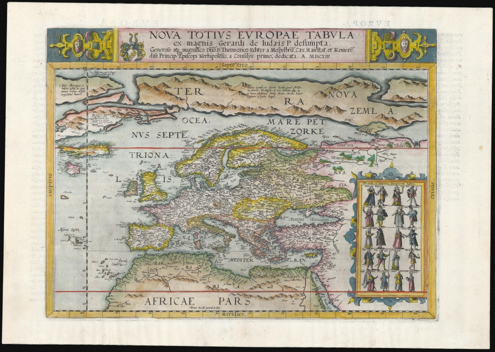
Nova Totius Europae Tabula.
1593 (dated) 13 x 17.5 in (33.02 x 44.45 cm)
1593 (dated) 13 x 17.5 in (33.02 x 44.45 cm)
Description
This is Cornelis De Jode's rare map of Europe, printed in a single edition of 1593. It was among the updated maps added to the De Jode atlas specifically to compete with Ortelius' powerhouse Theatrum Orbis Terrarum. To this end, it combined cartographic information from the most current sources with a level of decorative flourish that had not yet appeared in any atlas. It also presented its subject with a broader focus to incorporate newer information about the northern parts of the world not present on the elder De Jode's map.
A Closer Look
Centered on Europe, the map spans from northern Africa to the Arctic, reaching east to the mouth of the Ob River (although its detail for Russia largely disappears beyond the River Don.) The western limits of the map include Greenland, Iceland, and the phantom islands of Frisland and St. Brendan. The Azores and the Canary Islands are also present (and more accurately presented). The map is topped with an elegant title banner, with a dedication to the Prince-Bishop of Wurzburg. To the lower right, an inset presents miniature figures illustrating residents of various countries wearing their traditional styles. In addition to the more predictable European figures, there are some oddly specific additions: a woman from the island of Chios, for example, perhaps due to that island's recent capture by the Ottoman Empire. Also, Turkish and Persian soldiers are shown, as well as a 'Mancip ex Africa': a slave from Africa.Bringing the De Jode Atlas Up to Date
Although Cornelis credited this map to his father Gerard, this has to be taken as a gesture of filial loyalty. Gerard's mapping of Europe was obsolete in 1578 when it was published, especially compared to Ortelius' cartography. The present map is an entirely new production by Cornelius. He here drew on the cartography of Peter Plancius' 1592 wall map of the world. The east-west distortion reflects Plancius' cylindrical projection. Other notable characteristics are Plancius' reinterpretation of Mercator's Arctic landmasses, in particular, the identification of one of them as Nova Zemla. Iceland is placed correctly regarding its latitude and northwestern positioning vis-à-vis the British Isles (the elder De Jode had placed it almost due north of Scotland.) However, Nicolo Zeno's fraudulent regional geography is inherited from Plancius, including the fictitious monastery of St. Thomas in Greenland and the phantom island of Frisland.A War of Maps
Despite surpassing both Ortelius' and Gerard De Jode's maps in terms of accuracy and beauty, this map appeared only in the second and final 1593 edition of Gerard and Cornelis De Jode's Speculum Orbis Terrarum. The Speculum was unable to break Ortelius' lock on the market and was printed in only one edition. After Cornelis died in 1600, Jan Baptist Vrients (who was publishing Ortelius' atlas) purchased the De Jode plates and suppressed them (likely destroyed). There were thus no later printings of De Jode's maps.Publication History and Census
This map is rare. It was engraved for inclusion in Cornelis De Jode's Speculum Orbis Terrae, which was published in a sole edition of 1593 (the date in the cartouche contains a typographic error: the 'C' and 'X' are transposed, thus reading 1613 instead of the correct 1593). The map was not reprinted, the plates having been acquired from De Jode's widow by Ortelius' executor, Vrients, and destroyed to remove them from the market. This separate map appears in only two listings in OCLC, both giving the erroneous 1613 date. Perhaps a dozen examples of the Speculum appear in institutional collections.CartographerS
Cornelis de Jode (1568 – October 17, 1600) was an Antwerp cartographer, engraver and publisher, He was the son and heir of Gerard de Jode, also a cartographer and publisher. Cornelis studied science at Academy of Douai, but it can be understood that his main education in the trade was at the hands of his father. On his father's death in 1591, Cornelis de Jode took over the work on his father's atlas, Speculum Orbis Terrarum. This had enjoyed publication in a single edition of 1578, overshadowed by the competition posed by Abraham Ortelius' (1527 - 1598) Theatrum Orbis Terrrum. Cornelis published a second edition, to which he added many updated maps to bring the work up to date with its competition. Despite the improvements brought to the atlas, both aesthetic and geographic, De Jode was unable to break Ortelius' grip on the market and there were no further editions of the atlas. After his death, the engraving plates were sold to Ortelius' executor Johannes Baptista Vrients (1552 - 1612), who was continuing to publish the Theatrum. Vrients would utilize several decorative plates from the Speculum, but the complete work and its maps were not published again - likely they were destroyed by Vrients to keep them from competing with his editions of the i>Theatrum. More by this mapmaker...
Petrus Plancius (1522 - May 15, 1622) was a Dutch-Flemish cartographer, astronomer, and clergyman. Born in Dranouter, he studied theology in Germany and England. He became a minister in the Dutch Reformed Church at the age of 24. In 1585, fearing religious prosecution by the Inquisition after Brussels fell into Spanish hands, Plancius fled to Amsterdam. It was in Amsterdam that he became interested in navigation and cartography and soon became a recognized expert on the shipping routes to India. Plancius published his best known world map in 1592, entitled ‘Nova et exacta Terrarum Tabula geographic et hydrographica’. Plancius was also one of the founders of the Dutch East India Company, for which he drew over 100 maps. Learn More...
Source
De Jode, Cornelis, Speculum Orbis Terrarum, (Antwerp: Arnold Coninx) 1593.
Gerard De Jode (1516/17 - 1591) first issued his spectacular atlas, the Speculum Orbis Terrae, in Antwerp in 1578. The atlas was intended to compete with Abraham Ortelius' Theatrum Orbis Terrarum, and as such, was a lavish production, beautifully engraved and compiled from the best cartography of the period. De Jode drew from such illustrious sources as G. Gastaldi, Pirro Ligorio, Alvaro Seco, Lieven Algoet, Heinrich Zell, Wolfgang Lazius, Augustin Hirsvogel, Sebastian Rotenhan, Aegidius Tschudi, Bartholomaeus Scultetus, and Caspar Vopel. Like due to his lack of political connects and general business acumen, De Jode's Speculum never attained the widespread popularity of Ortelius' Theatrum. When Gerard died in 1591, the firm was taken over by his son, Cornelis de Jode (1568 - 1600) and, his wife, Paschina. C. De Jode partnered with Arnold Coninx to publish a new edition of the Speculum Orbis Terrae in 1593. Cornelius died young at 32, and the De Jode stock was sold to Johannes Baptista Vrients (1552 - 1612). Vrients had earlier acquired Ortelius's map plates and was actively republishing them. He did not similarly republish the Speculum Orbis Terrae; rather, his purchase of the De Jode plates was intended to keep them off the market. Most were destroyed at his hands, resulting in them never being reprinted and being exceptionally scarce today.
Condition
Excellent. Some faint spots in margin, else fine.
References
OCLC 494326779. Van der Krogt, P., Koeman's Atlantes Neerlandici. 1000:32B.