This item has been sold, but you can get on the Waitlist to be notified if another example becomes available, or purchase a digital scan.
1847 Vuillemin Pictorial Map of Europe
Europe-perrotvuillemin-1847$300.00


Title
Carte Pittoresque et Maritime de l'Europe Indiquant La division des Etats, let Routes et Chemins de fer...
1847 (dated) 33.5 x 43.75 in (85.09 x 111.125 cm) 1 : 5400000
1847 (dated) 33.5 x 43.75 in (85.09 x 111.125 cm) 1 : 5400000
Description
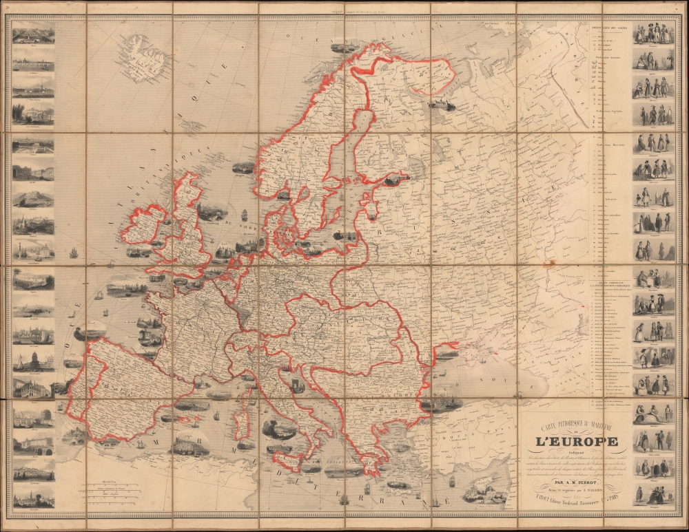
This is a striking 1847 Alexandre Vuillemin and Aristide-Michel Perrot pictorial map of Europe. The map has been updated in orange and gray manuscript to reflect the 1871 treaties that ended the Franco-Prussian War (1870 - 1871).
Throughout the map, European borders are modified in orange manuscript to reflect the new national boundaries established by the 1871 Treaty of Versailles at the end of the Franco-Prussian War. Gray pencil highlighting in the Alsace-Lorraine region reflects these territories' cessions to Germany.
A Closer Look
Coverage encompasses Europe from Portugal to the Ural Mountains, and from the Arctic Circle to the Mediterranean. The map is visually rich, with vignette views of port cities printed on the map near their locations. Additional views of 18 inland cities line the left border. The left border features 18 illustrations of European ethnicities in their traditional costumes. Throughout, train and road networks are illustrated.Throughout the map, European borders are modified in orange manuscript to reflect the new national boundaries established by the 1871 Treaty of Versailles at the end of the Franco-Prussian War. Gray pencil highlighting in the Alsace-Lorraine region reflects these territories' cessions to Germany.
The Franco-Prussian War
The Franco-Prussian War lasted from July 19, 1870 until January 28, 1871. The French suffered a series of defeats that eventually led to a siege on Paris, which lasted from September 17, 1870, until January 28, 1871. Over 180,000 Prussian and German soldiers laid siege to the city, and even though a reported 500,000 French soldiers occupied Paris, the Prussian army outclassed the French soldiers to such a degree that the French army could not break the siege. The Prussian commanders had no intention of attacking the city. However, as the siege wore on, it became obvious that such measures would be necessary. In the end, over 12,000 shells were fired on Paris in an effort to break Parisian morale. Paris also suffered horrible outbreaks of tuberculosis and other diseases. The Armistice was finally signed on January 27, and the siege was lifted. The Germans held a victory parade in Paris on March 1, 1871.Publication History and Census
This map was initially issued by Aristide-Michel Perrot. This 1847 example was updated by Alexandre Vuillemin and published by Charles Fatout. Perrot first published this map in 1842, and updated editions followed erratically through 1869. All editions are scarce in institutional collections and on the private market.CartographerS
Alexandre Aimé Vuillemin (1812 - 1880) was an engraver, publisher, and editor based in Paris, France in the middle of the 19th century. Despite a prolific publishing career, much of Vuillemin's life is shrouded in mystery. In 1852, he married Josephine Caroline Goret and they had at least one child, Ernestine Adèle Vuillemin, later in the same year. What is known is that his studied under the prominent French Auguste Henri Dufour (1798 - 1865). Vuillemin's most important work his detailed, highly decorative large format Atlas Illustre de Geographie Commerciale et Industrielle. More by this mapmaker...
Aristide Michel Perrot (1793 - 1879) was a French geographer, cartographer, and essayist active during the 19th century. Perrot specialized in miniature maps that appear in numerous French atlases. Perrot was also a prolific writer and his works include geographic lexicons and several essays. Learn More...
Charles Fatout (18?? - 1882) was a French engraver, bookseller, second-hand bookseller, map seller, print seller, bookbinder, and stationer active in Paris during the second half of the 19th century. From about 1840 he was based at Boulevard Poissonnière 17, an office he may have shared with other engravers and publishers of the period. In addition to his private work, he was also employed as a senior clerk under Damascène Morgand (1840 - 1898) in the second-hand book department of the Auguste Fontaine firm, Passage de Panoramas. In 1875, Morgand separated from Fontaine, and taking Fatout along, took over the bookshop of M. E. Caen, founding, 'Librairie Morgand et Fatout' at 55 Passage des Panoramas. Fatout is described in period literature as 'cold and calculating' leading to the success of his firm. Following Fatout's death in 1882, 'Morgand et Fatout' was formally dissolved, but the firm continued under 'Morgand' until 1897. At this time, himself ready to retire, Morgand sold the business at auction to Abbé Bossout, H. Destailleur, and Émile Müller. Learn More...
Condition
Very good. Dissected and mounted on linen in 32 panels. Wear along linen fold lines. Verso stabilization of linen fold separation.
References
OCLC 798812908.