This item has been sold, but you can get on the Waitlist to be notified if another example becomes available, or purchase a digital scan.
1851 Vuillemin Folding Map of Europe
Europe-vuillemin-1851$300.00

Title
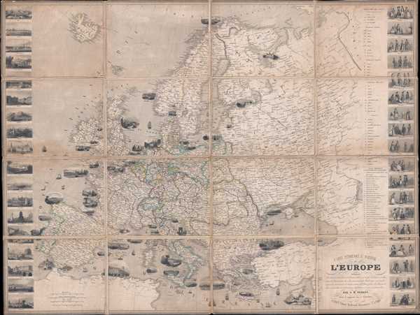
Carte Pittoresque et Maritime de l'Europe indiquant La division des Etats les Routes et Chemins de fer, la distance en kilometres de Paris à toutes les villes importantes, les Productions minerales, végétales et animales de chaque contrée, les Places fortes, les Ports militaires et marchands et l'itinéraire des bateaux à vapeur et paquebots.
1851 (dated) 32.5 x 43 in (82.55 x 109.22 cm) 1 : 6000000
1851 (dated) 32.5 x 43 in (82.55 x 109.22 cm) 1 : 6000000
Description
This is an 1851 Alexandre Vuillemin and Aristide Michel Perrot folding map of Europe. The map depicts the region from the Atlantic Ocean to the Ural Mountains and from the Arctic Ocean to the Mediterranean Sea and North Africa. Each of the countries is labeled, along with each capital city. Numerous other cities and towns are depicted and labeled, along with roads, railways, lakes, and rivers. Vignettes of several European cities dot the map, with scenes from Plymouth, Cherbourg, Bordeaux, Barcelona, Venice, Constantinople, and Hamburg among them. Various symbols are used throughout the map to depict different resources of the animal, vegetable, and mineral varieties, with a key for reading the symbols situated along the right. Along both the right and left borders, vignettes from numerous European countries are illustrated. On the right, caricatures of the typical inhabitants of different European countries are situated, including French, English, German, and Swedish people. On the left, views of European capital cities are included, such as Paris, London, Vienna, Berlin, Madrid, and Naples.
Why is Algeria on a map of Europe?
The inclusion of Algeria would appear to be a curiosity, even a mistake, since no other North African nation appears on the map, and this is stated to be a map of Europe. However, as this is a French map, its inclusion makes sense. In 1848, the coastal portion of Algeria was declared a department of France, making it administratively an integral part of France itself. This is unlike any other colony in the French overseas empire. France came to view Algeria as an inseparable part of metropolitan France, not was a colony. By including Algeria on this map, the Vuillemin is promoting the declaration that Algeria was not foreign soil but a part of France.
This map was originally drawn by Aristide Michel Perrot and 'reviewed an enhanced' by Alexandre Vuillemin in 1851.
CartographerS
Alexandre Aimé Vuillemin (1812 - 1880) was an engraver, publisher, and editor based in Paris, France in the middle of the 19th century. Despite a prolific publishing career, much of Vuillemin's life is shrouded in mystery. In 1852, he married Josephine Caroline Goret and they had at least one child, Ernestine Adèle Vuillemin, later in the same year. What is known is that his studied under the prominent French Auguste Henri Dufour (1798 - 1865). Vuillemin's most important work his detailed, highly decorative large format Atlas Illustre de Geographie Commerciale et Industrielle. More by this mapmaker...
Aristide Michel Perrot (1793 - 1879) was a French geographer, cartographer, and essayist active during the 19th century. Perrot specialized in miniature maps that appear in numerous French atlases. Perrot was also a prolific writer and his works include geographic lexicons and several essays. Learn More...
Condition
Very good. Dissected into 16 panels and mounted on linen. Light soiling. Blank on verso.
References
OCLC 71593273.