1947 Tschudi Map of World War II Campaigns in Europe and North Africa
FeldzugeEuropa-tschudi-1947$950.00


Title
Die Feldzüge in Europa 1939 - 1945.
1947 (undated) 37 x 48.5 in (93.98 x 123.19 cm) 1 : 5000000
1947 (undated) 37 x 48.5 in (93.98 x 123.19 cm) 1 : 5000000
Description
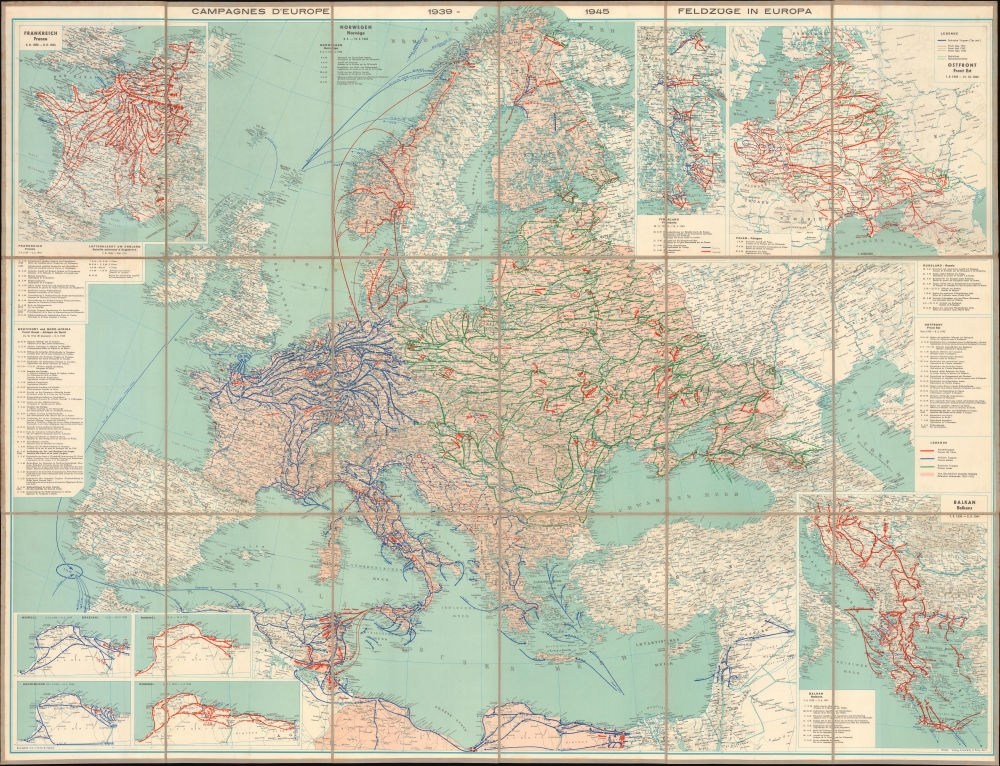
This is a c. 1947 Erwin Tschudi map of Europe and North Africa offering a striking visual summary of World War II in Europe.
The Central Map
Arrows with dates follow offensives and counteroffensives, allowing the viewer to trace the war from the German invasion of Poland to the final movements of the Allied armies in May 1945. The central map begins with the fighting in Denmark and Norway in April - June 1940. Then, it moves to the British and American Operation Torch landings in November 1942, as illustrated by a blue line from Britain to North Africa, where the landings are illustrated. Some of the fighting in North Africa is ignored (or instead covered by insets), but the fierce battles in Tunisia are chronicled. From here, the Allied armies invaded Sicily in July 1943 and then Italy in September 1943. The advance up Italy is chronicled through the end of the war in May 1945. The fighting on the Eastern Front is detailed from February 1943 until May 1945, using green arrows to highlight movements of the Soviet Red Army west from where they stopped the advancing German army to Germany. On the Western Front, arrows follow the Allied armies from June 5, 1944 (when the fleet assembled the day before the D-Day invasion of France) until the end of the war in May 1945. Red arrows highlight German counterattacks on both the Eastern and Western fronts, including the Battle of the Bulge.The Insets
Beginning in the upper left corner, the first inset highlights the German invasion of Belgium and the Netherlands and the Fall of France, as well as the Dunkirk Evacuation, the Dieppe raid, the raid on St. Nazaire, and the German invasion of the Unoccupied Zone in France in November 1942 after the Operation Torch landings. The insets on the Upper Right chronicle the Winter War between the Soviet Union and Finland between November 1939 and March 1940, the joint German-Soviet invasion of Poland between September 1, 1939, and December 1942, which includes the Nazi invasion of the Soviet Union, Operation Barbarossa. The inset in the lower right focuses on the war in the Balkans from April 1939 until June 1941. Four insets in the lower left focus on fighting in North Africa from 1940 through July 1942.Publication History and Census
This map was drafted by Erwin Tschudi and published by the Geographischer Verlag Kümmerly and Frey in Bern, Switzerland, c. 1947. This piece is not cataloged in OCLC and has no institutional representation. We note only a few examples that have appeared on the private market in recent years.CartographerS
Erwin Tschudi (February 13, 1908 - November 21, 1994) was a Swiss artist and historian. Tschudi was born in Bern, Switzerland. He is best known as a watercolor artist specializing in technical botanical illustrations, but in the late 1940s - 1960s he also worked with Kümmerly and Frey to produce several large-scale academic maps illustrating World War II. More by this mapmaker...
Hermann Kümmerly (September 6, 1857 - April 29, 1905) was a Swiss painter, lithographer, and cartographer. Kümmerly was born in Bern. He apprenticed as a lithographer under his father Gottfried, and also studied as a painter. He worked for a time for the Swiss Confederation's Topographic Bureau, which did not have its own printing company. In conjunction with Rudolf Leuzinger, the Kümmerly printing office gradually specialized in map printing. His maps became renowned for their vivid and accurate presentation of topography and in his naturalistic use of color in maps. He became particularly well known for his large school wall map of Switzerland, which has been hanging in virtually every school in Switzerland from 1903 until today. In 1898, his brother-in-law Otto Julius Frey joined the company as cartographer and co-owner, who now took the name Kümmerly and Frey. In 1931, Walter Kümmerly and Max Frey, the sons of the two predecessors, took over the management and skillfully steered the company through the years of crisis and World War II, despite the prohibition on map printing. In the post-war period, production shifted back to map production and book production with geographic themes. Since 1980, the fourth generation has been represented in the company management with Barbara Elisabeth Peters. Learn More...
Condition
Very good. Dissected and mounted on linen.