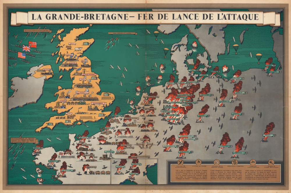
This is a 1943 F. Donald Blake French-language pictorial propaganda map of Great Britain and continental Europe at the height of World War II (1939 - 1945). The map's message is clear: the tide of war has turned, and British RAF forces are taking a heavy toll on Nazi-dominated Europe.
A Closer Look
Coverange embraces the British Isles and continental Europe from Ireland to Danzig. Royal Air Force bring destruction to Nazi Europe, bombing factories, airfields, railroads, bridges, and cities. Cities and war infrastructure throughout are in flames, but Paris remains unharmed. An inset along the bottom border focuses on northern Italy, where Turin, Milan, and Genoa burn. Meanwhile, in Britain, factories build tanks, airplanes, ships, and artillery. Coastal batteries guard the British coast, and the air defense fleet fans across the North Sea, the Atlantic, and the English Channel. Convoys of aid from the U.S. and Canada arrive in Britain from the upper left. At this point in the war, Britain had become the fer de lance de l'attaque [spearhead of attack].Publication History and Census
This map was drawn by Frederick Donald Blake and published in 1943. We note cataloged examples of the present edition as being part of Persuasive Maps: The PJ Mode Collection at Cornell University and the Princeton University Poster Collection at the National Museum of American History. The National Museum of American History also holds editions published in Italian, Arabic, and Persian. An English edition was also published. All editions are rare to the market.
Cartographer
Frederick Donald Blake (1908 - 1997) was a Scottish artist. Born in Greenock, Scotland, Blake and his family moved to London during his childhood. He attended the Camberwell School of Art and began working in an interior design business as an architectural draftsman at the age of fifteen. He was drafted in early 1940 and began working for the ministry of Information creating propaganda posters and maps. He also worked for the Daily Express three nights a week, creating war maps and impressions of battles. After the war, Blake worked as a freelance and commercial artist, creating works for the aircraft industry, bus companies, and the railways. Blake continued working as an artist for the rest of his life, with painting always taking first place. He gained a reputation as a painter, won the Hunting Art Prize in 1982 for his watercolor 'Stormy Harbor', and had work exhibited throughout Europe and the United States. More by this mapmaker...
Good. Wear along original fold lines. Some toning and foxing. Small area of infill. Closed edge tears that extend through border slightly into printed image repaired on verso.
Cornell University, Persuasive Maps: PJ Mode Collection ID Number 1315.01. National Museum of American History Princeton Poster Number 4332.