This item has been sold, but you can get on the Waitlist to be notified if another example becomes available.
1964 Highway 27 Association Map of Florida Highways
FLHighway27-highway27assn-1964$137.50


Title
Complete Map: Florida Traveling, featuring U.S. 27.
1964 (undated) 22.25 x 8.5 in (56.515 x 21.59 cm) 1 : 1480000
1964 (undated) 22.25 x 8.5 in (56.515 x 21.59 cm) 1 : 1480000
Description
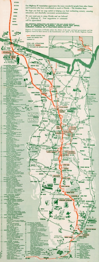
A fun c. 1964 folding strip road map produced by the Highway 27 Association of Florida. It highlights the organization's namesake highway, connecting Tallahassee to Miami, while also providing detail on other highways, tourist attractions, and local attractions.
In Florida, Interstate 75 was originally intended to end at Tampa but it was later extended to Miami, a process not completed until 1986 given the difficulties and environmental concerns entailed in building the freeway across the Everglades. The resulting route left a flat, straight track of road running east-west between Naples and Fort Lauderdale dubbed Alligator Alley (or more pleasantly, the Everglades Parkway).
A Closer Look
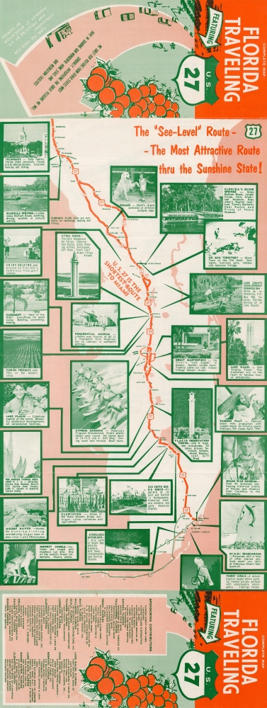
An impressive map of Florida is presented, with the route of U.S. 27, including a connection with U.S. 1 (the Overseas Highway) through the Florida Keys, bolded in orange. At left, a list of towns, cities, and attractions along the route are indicated along with distances. Illustrations depict local wildlife, sports, and leisure activities throughout the state, including museums of wax figures, wildlife 'jungles,' a passion play, Everglades Gatorland, and an Old West theme park called Six Gun Territory. A small inset toward top-right displays the Florida Panhandle. The verso provides photographs of attractions noted on the recto as well as a list of businesses and organizations supporting the Highway 27 Association.U.S. 27
U.S. Route 27 connects Miami, Florida with Fort Wayne, Indiana (formerly, briefly, reaching Michigan's Upper Peninsula in the late 1950s before that portion of the road was incorporated into Interstate 75). It was designated in the late 1920s-1930s and largely replaced the eastern branch of the 'Dixie Highway,' which was more accurately a network of roads that were expanded and extended in the 1910s-1920s with the support of a booster organization similar to the makers of this map. U.S. 27 continues to service drivers, but was surpassed by Interstate 75, which follows a similar route.In Florida, Interstate 75 was originally intended to end at Tampa but it was later extended to Miami, a process not completed until 1986 given the difficulties and environmental concerns entailed in building the freeway across the Everglades. The resulting route left a flat, straight track of road running east-west between Naples and Fort Lauderdale dubbed Alligator Alley (or more pleasantly, the Everglades Parkway).
Highway Associations
The movement promoting the construction of 'good quality' roads did not begin with the invention of the automobile, but rather with the bicycle. At the time, most interurban roads were unpaved and impractical for cycling. The 'Good Roads Movement' was inaugurated in May 1880 to advocate for bicycle enthusiasts, riding clubs, and manufacturers. By 1910, the American Automobile Association (AAA) jumped onboard, along with over one hundred other local and national organizations. 'Road booster' organizations emerged to promote specific, often branded, highways. By the 1920s, about 250 'named' highways, each with their own boosters, crossed the United States. 'Road boosters' still exist, but most disbanded in the 1950s and 60s with the emergence federally funded Interstate Highway System.Publication History and Census
This map was produced and published by the Highway 27 Association of Florida. It is undated but likely dates from around 1964, suggested by the reference on the verso to 'Presidents from Washington to Johnson' and the inclusion of Interstate 75 and its terminus at an intersection with the Florida State Turnpike at Wildwood near Leesburg. This map is not known to exist in any institutional holdings, and we can locate no other identical examples, only one example of a very similar map published by the Highway 27 Association with some changes to the photos on the verso and other minor differences.Condition
Very good. Some wear along fold lines.