This copy is copyright protected.
Copyright © 2024 Geographicus Rare Antique Maps
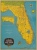
1948 Florida East Coast Railway Map of Florida and the FEC
FloridaEastCoastRailway-ecr-1948


Copyright © 2024 Geographicus Rare Antique Maps | Geographicus Rare Antique Maps
This copy is copyright protected.
Copyright © 2024 Geographicus Rare Antique Maps