This item has been sold, but you can get on the Waitlist to be notified if another example becomes available, or purchase a digital scan.
1550 Münster Map of France
France-munster-1550$250.00


Title
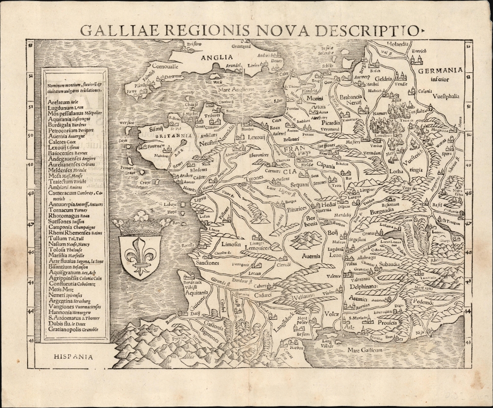
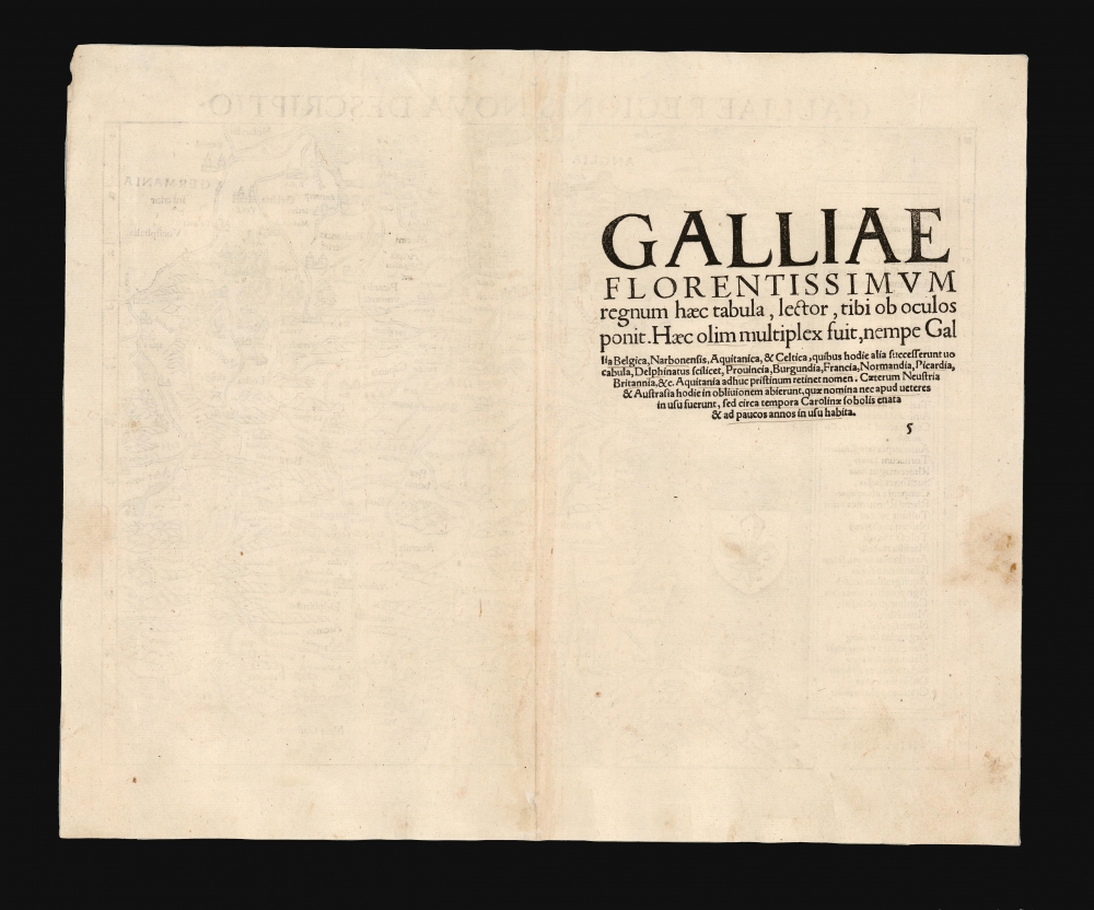
Galliae Regionis Nova Descriptio.
1550 (undated) 10.5 x 13.5 in (26.67 x 34.29 cm) 1 : 5000000
1550 (undated) 10.5 x 13.5 in (26.67 x 34.29 cm) 1 : 5000000
Description
This elegant 1550 woodcut map by Sebastian Münster is one of the earliest acquirable true modern maps of France, being based on the unacquirable 1525 Oronce Finé Nova Totius Galliae descriptio, the first map of France produced in France based on contemporaneous observations. Münster's work is the earliest acquirable derivative of that groundbreaking map.
Within these bounds, France is shown in detail, with rivers, cities, and provinces laid out using contemporary terminology. In the sea west of Bordeaux, the Royal Fleur de Lis is displayed. At the left, Münster has provided a table listing the Latin placenames typically used for French locales, and their vernacular translations. (For example, the Latin Bisantium to the French Besanson; Argentina Strasburg and so on.)
Oronce Finé's 1525 Nova Totius Galliae Descriptio, the source upon which the present work relied, achieved a higher standard of precision and quality over these earlier maps. It was based on Finé's superior determinations of latitude and longitude for more than a hundred cities, towns, and villages: these were assembled from an array of observers but checked personally. No earlier map of France could boast this level of accuracy because no earlier map of France was actually produced there.
Münster was quite familiar with both the 1482 Ptolemy and the 1513 Waldseemüller, and many of his other maps owe debts to these works, but it is a testament to the attention Münster paid to current sources that his modern map of France relied not on these but on the 1525 Finé. The present work is more focused on France proper than the Finé, which stretched far enough east to show all of northern Italy, inclusive of the Republic of Venice; it is necessarily a smaller work, printed to a single sheet rather than the four of the source map. But its presentation of the mountains, rivers and cities of France reflects the accuracy applied to the project by Finé, and represents the best acquirable mapping of the country produced until Ortelius in the second half of the century. Only a handful of the original printings of Finé's map survive (absolutely none of the 1525 first edition among them), and even the Forlani and Zaltieri copperplate copies of the Finé command five-digit prices on the rare occasions that they have appeared on the market. Münster captured in this map the state-of-the-art of French mapping, and the success of his work disseminated that mapping far beyond what the original would have achieved - with the happy result that this superb map is available to the collector.
France and the Adjacent Countries
This woodcut presents France, bounded at north and south by the 'English Sea' and the 'French Sea' (The English Channel and the Mediterranean Sea, respectively.) At the north of the map the southern coasts of England are shown, including Bristol and Gravesend. On the mainland, the map reaches as far north as Holland. Germany appears east of the lower Rhine. It extends east to include Switzerland, with Lakes Geneva, Lucern, and Zurich. Savoy and Piedmont appear in the southeast. The southwest is dominated by the forbidding Pyrenees Mountains.Within these bounds, France is shown in detail, with rivers, cities, and provinces laid out using contemporary terminology. In the sea west of Bordeaux, the Royal Fleur de Lis is displayed. At the left, Münster has provided a table listing the Latin placenames typically used for French locales, and their vernacular translations. (For example, the Latin Bisantium to the French Besanson; Argentina Strasburg and so on.)
The Source Map and its Precursors
The story of the 'modern' printed mapping of France starts with theTabula Moderna of France for inclusion in the 1482 Ulm Ptolemy; followed by Waldseemüller's 1513 Tabula Modern Gallie. The 1513 map was based on 16th-century travelers' maps, as incorporated in Waldseemüller's 1511 Carta Itinerarea Europae, and was consequently far superior to the 15th-century map, but both of these reflected contemporaneous geographical knowledge and deserve classification as modern maps.Oronce Finé's 1525 Nova Totius Galliae Descriptio, the source upon which the present work relied, achieved a higher standard of precision and quality over these earlier maps. It was based on Finé's superior determinations of latitude and longitude for more than a hundred cities, towns, and villages: these were assembled from an array of observers but checked personally. No earlier map of France could boast this level of accuracy because no earlier map of France was actually produced there.
Münster was quite familiar with both the 1482 Ptolemy and the 1513 Waldseemüller, and many of his other maps owe debts to these works, but it is a testament to the attention Münster paid to current sources that his modern map of France relied not on these but on the 1525 Finé. The present work is more focused on France proper than the Finé, which stretched far enough east to show all of northern Italy, inclusive of the Republic of Venice; it is necessarily a smaller work, printed to a single sheet rather than the four of the source map. But its presentation of the mountains, rivers and cities of France reflects the accuracy applied to the project by Finé, and represents the best acquirable mapping of the country produced until Ortelius in the second half of the century. Only a handful of the original printings of Finé's map survive (absolutely none of the 1525 first edition among them), and even the Forlani and Zaltieri copperplate copies of the Finé command five-digit prices on the rare occasions that they have appeared on the market. Münster captured in this map the state-of-the-art of French mapping, and the success of his work disseminated that mapping far beyond what the original would have achieved - with the happy result that this superb map is available to the collector.
Publication History and Census
This woodcut was first executed by an unknown artist for inclusion in Münster 1540 edition of Geographia; in 1544 it was added to Münster's masterwork, Cosmographia. It appeared in that work until its 1578 edition. The present example conforms typographically to the 1550 Latin edition of Cosmographia, among the editions completed during the author's lifetime. Some examples of the 1552 Latin edition appear to have been made up of the same printed sheets as the 1550, although observed examples of the 1552 are distinct typographically, leading us to the conclusion that much of the 1552 run was assembled from remaining printed stock of the 1550 edition prior to a new typesetting. Only two separate examples of this edition appear in OCLC, although in other editions it is well represented. The map appears on the market from time to time in various editions.CartographerS
Sebastian Münster (January 20, 1488 - May 26, 1552), was a German cartographer, cosmographer, Hebrew scholar and humanist. He was born at Ingelheim near Mainz, the son of Andreas Munster. He completed his studies at the Eberhard-Karls-Universität Tübingen in 1518, after which he was appointed to the University of Basel in 1527. As Professor of Hebrew, he edited the Hebrew Bible, accompanied by a Latin translation. In 1540 he published a Latin edition of Ptolemy's Geographia, which presented the ancient cartographer's 2nd century geographical data supplemented systematically with maps of the modern world. This was followed by what can be considered his principal work, the Cosmographia. First issued in 1544, this was the earliest German description of the modern world. It would become the go-to book for any literate layperson who wished to know about anywhere that was further than a day's journey from home. In preparation for his work on Cosmographia, Münster reached out to humanists around Europe and especially within the Holy Roman Empire, enlisting colleagues to provide him with up-to-date maps and views of their countries and cities, with the result that the book contains a disproportionate number of maps providing the first modern depictions of the areas they depict. Münster, as a religious man, was not producing a travel guide. Just as his work in ancient languages was intended to provide his students with as direct a connection as possible to scriptural revelation, his object in producing Cosmographia was to provide the reader with a description of all of creation: a further means of gaining revelation. The book, unsurprisingly, proved popular and was reissued in numerous editions and languages including Latin, French, Italian, and Czech. The last German edition was published in 1628, long after Münster's death of the plague in 1552. Cosmographia was one of the most successful and popular books of the 16th century, passing through 24 editions between 1544 and 1628. This success was due in part to its fascinating woodcuts (some by Hans Holbein the Younger, Urs Graf, Hans Rudolph Manuel Deutsch, and David Kandel). Münster's work was highly influential in reviving classical geography in 16th century Europe, and providing the intellectual foundations for the production of later compilations of cartographic work, such as Ortelius' Theatrum Orbis Terrarum Münster's output includes a small format 1536 map of Europe; the 1532 Grynaeus map of the world is also attributed to him. His non-geographical output includes Dictionarium trilingue in Latin, Greek, and Hebrew, and his 1537 Hebrew Gospel of Matthew. Most of Munster's work was published by his stepson, Heinrich Petri (Henricus Petrus), and his son Sebastian Henric Petri. More by this mapmaker...
Oronce Finé (December 20, 1494 - August 8, 1555), also known as Orontius Finnaeus, was a French astronomer, astrologer, mathematician, and cartographer active in Paris in the first half of the 16th century. Finé was born in Briançon, the son and grandson of prominent physicians. He was educated in Paris at the Collège de Navarre, where in1522 he was awarded a medical degree. As a young man he became involved with judicial astrology, a pseudoscience that involved predicting future events based upon complex mathematical calculations derived from careful observations of planetary and stellar bodies. This practice was declared heretical by the catholic church and led to Finé's temporary arrest and imprisonment in 1524. Nonetheless by 1531 he was appointed to the chair of mathematics at the Collège Royal (the present Collège de France), founded by King Francis I. This was a position he would retain throughout his life. Finé became one of the most prolific authors of mathematical books of his age. He worked in a wide range of mathematical fields, including practical geometry, arithmetic, optics, gnomonics, astronomy, and instrumentalism. In cartography, Finé is known for several maps, including a revolutionary 1525 map of France. Significantly, he introduced the cordiform (heart-shaped) projection model in an attempt to address the curvature of the Earth on a two-dimensional plane. Finé issued two cordiform world maps, a single heart-shaped map representing the known world, and a double cordiform projection detailing expanding from the north and south polar regions. His work was both revolutionary and widely copied in the subsequent century. Finé died in Paris at 60. The lunar crater Orontius and Finaeus Cove in Antarctica are named after him. In 2014, a square named after Oronce Fine was inaugurated in Paris. Learn More...
Heinrich Petri (1508 - 1579) and his son Sebastian Henric Petri (1545 – 1627) were printers based in Basel, Switzerland. Heinrich was the son of the printer Adam Petri and Anna Selber. After Adam died in 1527, Anna married the humanist and geographer Sebastian Münster - one of Adam's collaborators. Sebastian contracted his stepson, Henricus Petri (Petrus), to print editions of his wildly popular Cosmographia. Later Petri, brought his son, Sebastian Henric Petri, into the family business. Their firm was known as the Officina Henricpetrina. In addition to the Cosmographia, they also published a number of other seminal works including the 1566 second edition of Nicolaus Copernicus's De Revolutionibus Orbium Coelestium and Georg Joachim Rheticus's Narratio. Learn More...
Source
Münster, Sebastian, Cosmographia, (Basel: Petri), Latin Edition, 1550.
The Cosmographia Universalis, one of the greatest geographical and historical works of the 16th century, 'taught nearly three generations of laymen most of what they knew about the world beyond their native places' (Strauss). Filled with maps, views, and rich descriptions of places throughout Europe and beyond, it was the best general source of geographical information until the advent of Ortelius' Theatrum. It was first issued by Sebastian Munster (1488 - 1552) in its 1544 German edition, and stayed in print long after its author's death in thirty five editions, and in five languages. (Of these, the 1550 and 1552 editions are widely regarded as the most complete and truest to the author's intentions: thereafter, later editors continued to add to the work's text; editions from 1588 onwards employed an entirely different set of maps produced on Ortelius' model.) Munster's goal, initially, was to rally his homeland's humanists and scholars to produce a new map of Germany in order to 'see what kind of a land our ancestors conquered for their home... bring honor to our country and place its beauties in the clear light of day.' Munster's project quickly expanded to cover the known world in its scope to produce a 'sufficiently large volume, in which I touch upon the foundation of all nations and kingdoms, their peculiarities, rivers, mountains, customs of men, royal successions, origins of the more important cities, succinct histories, religions, characteristics and fertility of lands... in Germany, however, I tarry a little longer'.
Munster's methodology in Cosmographia is notable in particular for his dedication to providing his readers with direct access to firsthand reports of his subjects wherever possible. Many of the maps were the result of his own surveys; others, the fruit of an indefatigable letter writing campaign to scholars, churchmen and princes throughout Europe, amicably badgering them for maps, views, and detailed descriptions of their lands. For lands further afield than his letters could reach, Munster relied on the best that the authorities of northern European scholarship could offer: he was well familiar with the work of Waldseemuller and other geographers of the early 16th century, and was well connected with the best geographers of his own generation. A disproportionate number of the maps of Cosmographia show contemporary geographical knowledge of the their respective areas for the very first time: The first map to show the continents of the Western Hemisphere; the first map to focus on the continent of Asia; the first modern map to name the Pacific Ocean; the first map to use a key; the first modern map of the British Isles and so on. Even in cases where earlier maps exist, Munster's works very often remain the earliest such acquirable by the collector.
Munster's methodology in Cosmographia is notable in particular for his dedication to providing his readers with direct access to firsthand reports of his subjects wherever possible. Many of the maps were the result of his own surveys; others, the fruit of an indefatigable letter writing campaign to scholars, churchmen and princes throughout Europe, amicably badgering them for maps, views, and detailed descriptions of their lands. For lands further afield than his letters could reach, Munster relied on the best that the authorities of northern European scholarship could offer: he was well familiar with the work of Waldseemuller and other geographers of the early 16th century, and was well connected with the best geographers of his own generation. A disproportionate number of the maps of Cosmographia show contemporary geographical knowledge of the their respective areas for the very first time: The first map to show the continents of the Western Hemisphere; the first map to focus on the continent of Asia; the first modern map to name the Pacific Ocean; the first map to use a key; the first modern map of the British Isles and so on. Even in cases where earlier maps exist, Munster's works very often remain the earliest such acquirable by the collector.
Condition
Very good. Marginal mends and slight soiling outside printed image; else excellent.
References
OCLC 224196883. Rumsey 11623.071 (1540 Geographia).