This item has been sold, but you can get on the Waitlist to be notified if another example becomes available, or purchase a digital scan.
1941 Kürzl and Brinkman German World War II Route Map of the French Campaign
FrankreichFeldzug-kurzlbrinkman-1941$250.00

Title
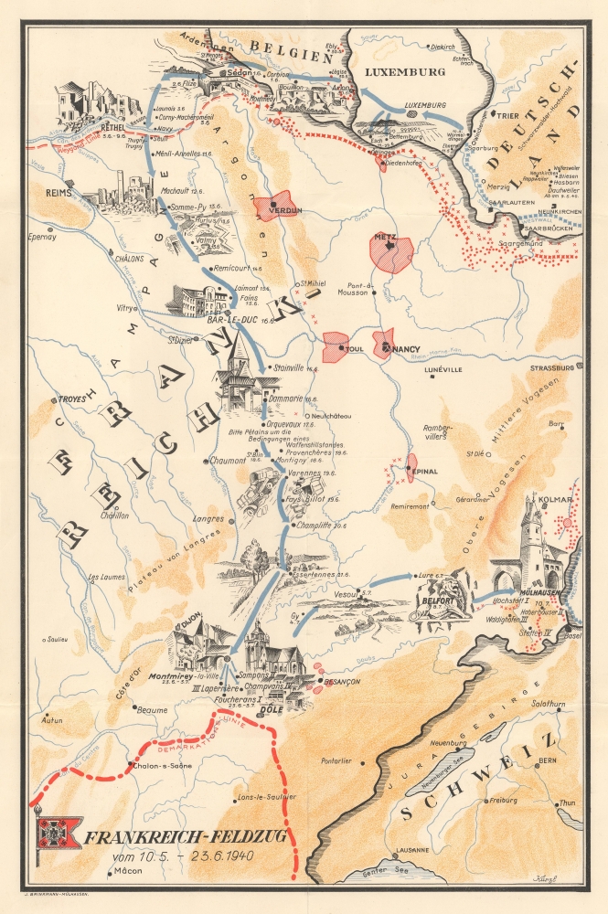
Frankreich-Feldzug vom 10.5 - 23.6.1940.
1941 (undated) 16.75 x 11 in (42.545 x 27.94 cm)
1941 (undated) 16.75 x 11 in (42.545 x 27.94 cm)
Description
An extremely rare find, this is a c. 1941 German World War II route map of France illustrating a German unit's movements during the 1940 Battle of France. German World War II route maps are much less prominent than comparable maps made for American and British units. Here, dates when the unit entered French cities and villages in June and July 1940 are noted, creating a narrative of the unit's movements.
A Closer Look
Blue arrows follow the unit's movements from Wormeldingen in Luxembourg on May 10 through Belgium and across the French border near Sedan on June 1. From Sedan, the unit moved south through the Champagne region and Bar-le-Duc to Montmirey-la-Ville and surrounding villages, where they stayed from June 23 until July 3. After leaving the Montmirey region, the unit moved northeast through Vesoul, Lure, and Belfor before arriving in Mulhouse (Mülhausen). Pictorial vignettes highlight several towns along the route, many in ruins. Red lines mark the Maginot and Weygand lines and the demarcation line between the Occupied and Unoccupied Zones.The Battle of France
The Battle of France (May 10, 1940 - June 25, 1940) refers to the Nazi German invasion of France and the Low Countries. In a matter of 6 weeks, the Nazis routed the French army and forced the capitulation of the French government. Marshal Philippe Pétain took control of the government after the fall of the Third Republic and signed an armistice with the Germans on June 22, 1940. As part of the armistice, France was divided into an Occupied Zone governed the German military and an Unoccupied Zone governed by Marshal Pétain from the spa town of Vichy. Germany invaded the Unoccupied or 'free' Zone after the Allied invasion of North Africa in November 1942 and controlled it until liberation in 1944.Publication History and Census
This map was created by a cartographer known only as 'Kürzl' and published by J. Brinkmann in Mulhouse. Given that the latest date provided is July 7, when the unit in question was in Mulhouse, this map's publication date must postdate that. Given the lack of post-war unit histories dedicated to German units, this map must have been published between July 1940 and the June 1944 Allied invasion of France.Cartographer
Imprimerie J. Brinkmann (1857 - 1940; 1946 - 1953) was a publishing house in Mulhouse, France. We have been unable to trace the founder. The publishing house was very active during World War I, publishing posters and announcements for the town of Mulhouse. After World War I, Brinkmann published a few unit histories for French infantry battalions. According to records in the Bibliothèque nationale de France, the Imprimerie Brinkmann did not publish during World War II and the German occupation of France. However, we have encountered a German World War II route map of the French campaign that ends in Mulhouse that bears the imprint 'J. Brinkmann - Mülhausen'. We have been unable to trace its source, but believe it to have been printed in a unit history published by Brinkmann for a German unit. More by this mapmaker...
Condition
Very good. Light wear along original fold lines.