Digital Image: 1916 Irving National Bank Map of New York City Freight Terminals
FreightTerminal-irving-1916_d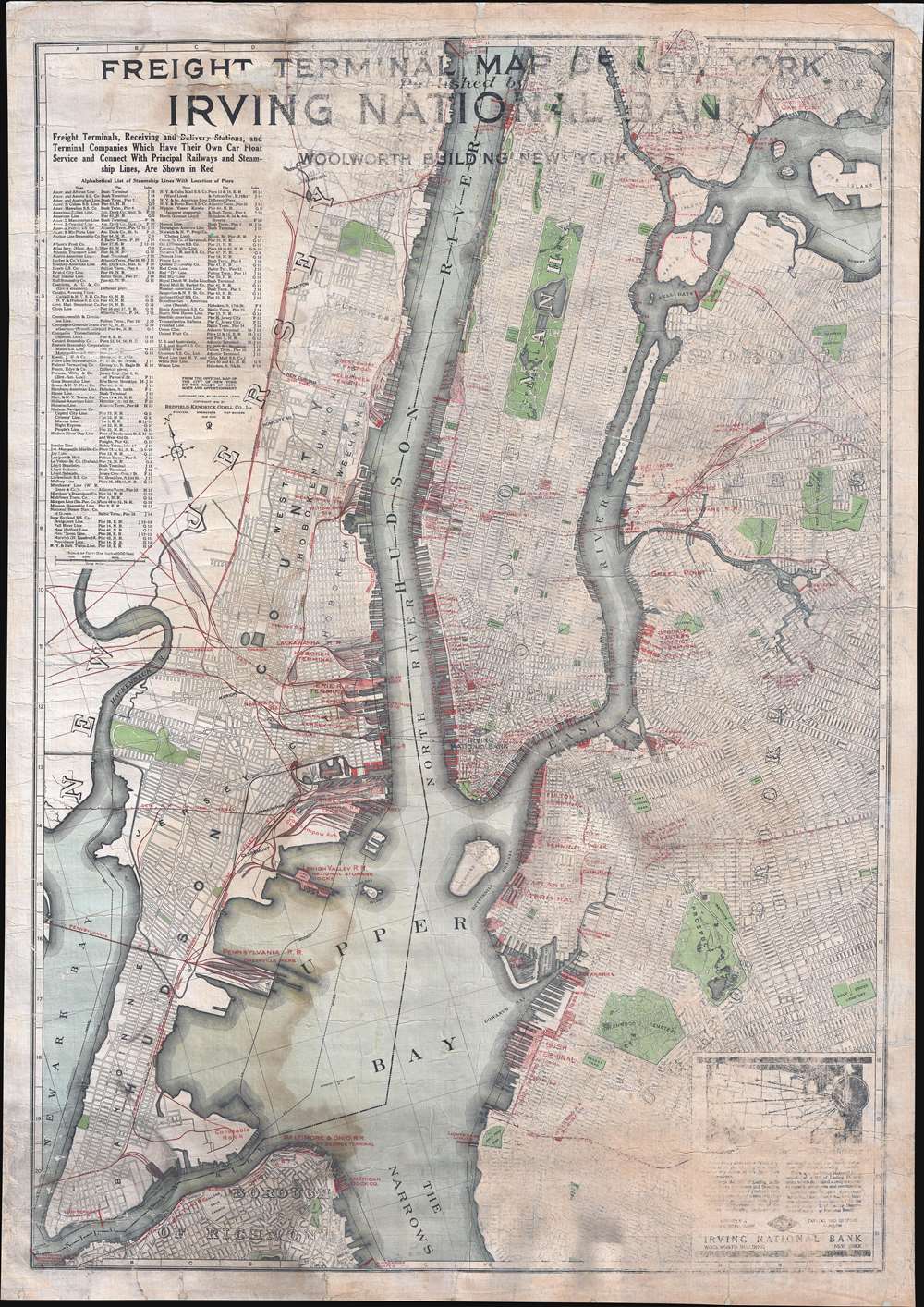

Title
Freight Terminal Map of New York. Published by Irving National Bank.
1916 (undated) 43 x 30.5 in (109.22 x 77.47 cm) 1 : 24000
1916 (undated) 43 x 30.5 in (109.22 x 77.47 cm) 1 : 24000
Description
FOR THE ORIGINAL ANTIQUE MAP, WITH HISTORICAL ANALYSIS, CLICK HERE.
Digital Map Information
Geographicus maintains an archive of high-resolution rare map scans. We scan our maps at 300 DPI or higher, with newer images being 600 DPI, (either TIFF or JPEG, depending on when the scan was done) which is most cases in suitable for enlargement and printing.
Delivery
Once you purchase our digital scan service, you will receive a download link via email - usually within seconds. Digital orders are delivered as ZIP files, an industry standard file compression protocol that any computer should be able to unpack. Some of our files are very large, and can take some time to download. Most files are saved into your computer's 'Downloads' folder. All delivery is electronic. No physical product is shipped.
Credit and Scope of Use
You can use your digial image any way you want! Our digital images are unrestricted by copyright and can be used, modified, and published freely. The textual description that accompanies the original antique map is not included in the sale of digital images and remains protected by copyright. That said, we put significant care and effort into scanning and editing these maps, and we’d appreciate a credit when possible. Should you wish to credit us, please use the following credit line:
Courtesy of Geographicus Rare Antique Maps (http://www.geographicus.com).
How Large Can I Print?
In general, at 300 DPI, you should at least be able to double the size of the actual image, more so with our 600 DPI images. So, if the original was 10 x 12 inches, you can print at 20 x 24 inches, without quality loss. If your display requirements can accommodate some loss in image quality, you can make it even larger. That being said, no quality of scan will allow you to blow up at 10 x 12 inch map to wall size without significant quality loss. For more information, it is best consult a printer or reprographics specialist.
Refunds
If the high resolution image you ordered is unavailable, we will fully refund your purchase. Otherwise, digital images scans are a service, not a tangible product, and cannot be returned or refunded once the download link is used.
Cartographer S
The Redfield-Kendrick-Odell Company (fl. c. 1913 - 1933) was a printing, mapmaking, and engraving firm based in New York City that was active during the early 20th century. More by this mapmaker...
Irving Trust (1851 - 1988) was an American investment bank based in New York City and was founded in 1851 as the Irving Bank of the City of New York. At that time in U.S. history, a federal currency did not exist, which meant that individual banks issued their own paper certificates, and, as is the case with most endeavors in human society, those banks with the most appealing names and most attractive certificates were the most widely used. Irving Bank was named after Washington Irving, and American diplomat, lawyer, and author who became recognized as America's first man of letters. Irving Bank was converted from a state bank to a bank chartered under the National Bank Act of 1863 in June 1865, and became the Irving National Bank of New York. After a merger in 1907, the bank became the Irving National Exchange Bank of New York, and subsequently changed its name to the Irving National Bank in 1912. The Irving National Bank merged with the Columbia Trust Company in 1922, which created the Irving Bank and Trust Company. Another merger in 1926 with the American Exchange-Pacific Bank led to the company being renamed the American Exchange Irving Trust Company. In 1929, the bank underwent its final name change to the Irving Trust Company, the name under which it operated until 1989. Irving Trust ceased to exist on October 7, 1988, after the board signed an agreement to merge with the Bank of New York, which ended a yearlong battle between the two as the Bank of New York tried to engineer a hostile takeover. Learn More...
Nelson Peter Lewis (1856 - 1924) was an American civil engineer. From 1902 until 1920, Lewis served as chief engineer of Brooklyn, New York. He authored The Planning of the Modern City in 1916 and became the Director of the Physical Survey of the Regional Plan of New York and Its Environs in May 1921. Learn More...
References
OCLC 10616421.