1704 Mortier / Blaeu View of Gaeta, Italy
Gaeta-mortier-1704$500.00

Title
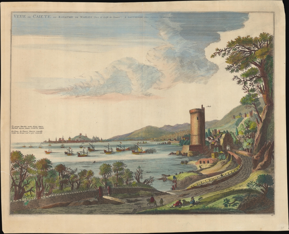
Veue de Caiete du Royaume de Naples. vers le Golfe de Venise.
1704 (undated) 16.5 x 22 in (41.91 x 55.88 cm)
1704 (undated) 16.5 x 22 in (41.91 x 55.88 cm)
Description
A lovely c. 1704 view of Gaeta, Italy, originally prepared by Johannes Blaeu in 1663 for the Theatrum Civitatum et Admirandorum Italiæ and reissued with minor changes by Pierre Mortier for his Nouveau Theatre d'Italie.
Instead, the hill above the town appears to depict one of several ancient coastal mausoleums belonging to Roman elites (likely the Mausoleo di Lucio Munazio Planco), who adored the city, then known as Caieta, and built opulent villas there during their lifetimes. Within the Medieval town, some structures, namely church spires and domes, are clearly recognizable, including the tower of Gaeta's cathedral. The road in the foreground is noted as being part of the Appian Way. A note on the left in both Latin and French refers to the origins of the town's name: Caieta was the wet nurse of the Trojan warrior Aeneas and, according to Virgil, was buried along the bay seen here. Multiple ships are in the bay before the town, two of which are firing cannons. The reference to an actual battle, if any, is unclear. The ships also appear in Blaeu's version, issued when Gaeta had not seen a naval battle for decades.
A Closer Look
The view is oriented roughly towards the east-southeast. Blaeu's work in the Theatrum civitatum was based on his own travels in Italy as a youth, his son's journey to Italy to prepare for the work, their contacts on the peninsula, and earlier published works such as Braun and Hogenberg's Civitates Orbis Terrarum. Despite all these efforts, some maps and views relied on outdated or incomplete information. The present view may be one such example. Most notably, the fortifications on the hillside at right, labeled 'Castel Nuovo' in Blaeu's original, are meant to be the imposing fortress that sits atop a hill directly above the medieval town seen in the distance here rather than some distance away as depicted. The fortress dates back as early as the 6th century but was considerably elaborated by the Habsburg Emperor Charles V after his forces recaptured the city from a brief French interregnum in the late 1520s. Afterward, it was considered one of the most formidable fortresses in Europe, despite being captured in the War of the Spanish Succession, War of Polish Succession, the Napoleonic Wars, and the Risorgimento, though in each case after a siege of several months. The dramatic elevation of the town itself, culminating in Monte Orlando, is also understated here.Instead, the hill above the town appears to depict one of several ancient coastal mausoleums belonging to Roman elites (likely the Mausoleo di Lucio Munazio Planco), who adored the city, then known as Caieta, and built opulent villas there during their lifetimes. Within the Medieval town, some structures, namely church spires and domes, are clearly recognizable, including the tower of Gaeta's cathedral. The road in the foreground is noted as being part of the Appian Way. A note on the left in both Latin and French refers to the origins of the town's name: Caieta was the wet nurse of the Trojan warrior Aeneas and, according to Virgil, was buried along the bay seen here. Multiple ships are in the bay before the town, two of which are firing cannons. The reference to an actual battle, if any, is unclear. The ships also appear in Blaeu's version, issued when Gaeta had not seen a naval battle for decades.
Publication History and Census
This view originally appeared in Johannes Blaeu's 1663 Theatrum civitatum et admirandorum Italiæ, where it was titled 'Elegantissimus Ad Mare Tyrrhenum Caietae Prospectus,' which was itself strongly influenced by Braun and Hogenberg's 1572 view of the same name. It was then slightly modified and reprinted by Pierre Mortier for his Nouveau theatre d'Italie in 1704 (or perhaps in the 1724 reissue of Mortier's work). This view is only independently cataloged in the OCLC among the holdings of the Bayerische Staatsbibliothek and is scarce to the market, especially in such vivid hand color.CartographerS
Joan (Johannes) Blaeu (September 23, 1596 - December 21, 1673) was a Dutch cartographer active in the 17th century. Joan was the son of Willem Janszoon Blaeu, founder of the Blaeu firm. Like his father Willem, Johannes was born in Alkmaar, North Holland. He studied Law, attaining a doctorate, before moving to Amsterdam to join the family mapmaking business. In 1633, Willem arranged for Johannes to take over Hessel Gerritsz's position as the official chartmaker of the Dutch East India Company, although little is known of his work for that organization, which was by contract and oath secretive. What is known is his work supplying the fabulously wealthy VOC with charts was exceedingly profitable. Where other cartographers often fell into financial ruin, the Blaeu firm thrived. It was most likely those profits that allowed the firm to publish the Theatrum Orbis Terrarum, sive, Atlas Novus, their most significant and best-known publication. When Willem Blaeu died in 1638, Johannes, along with his brother Cornelius Blaeu (1616 - 1648) took over the management of the Blaeu firm. In 1662, Joan and Cornelius produced a vastly expanded and updated work, the Atlas Maior, whose handful of editions ranged from 9 to an astonishing 12 volumes. Under the brothers' capable management, the firm continued to prosper until the 1672 Great Amsterdam Fire destroyed their offices and most of their printing plates. Johannes Blaeu, witnessing the destruction of his life's work, died in despondence the following year. He is buried in the Dutch Reformist cemetery of Westerkerk. Johannes Blaeu was survived by his son, also Johannes but commonly called Joan II, who inherited the family's VOC contract, for whom he compiled maps until 1712. More by this mapmaker...
Pierre Mortier (January 26, 1661 - February 18, 1711) or Pieter Mortier was a cartographer, engraver, and print seller active in Amsterdam during the later 17th and early 18th centuries. Mortier, then known as Pieter, was born in Leiden. He relocated to Paris from 1681 to 1685, adopting the French name Pierre, which he retained throughout his career. While in France, he developed deep French connections by bringing sophisticated Dutch printing technology and experience to nascent French map publishers such as Guillaume De L'Isle (1675 - 1726), Alexis-Hubert Jaillot (c. 1632 - 1712), and Nicholas de Fer (1646 - 1720). Consequently, much of Mortier's business was built upon issuing embellished high quality editions of contemporary French maps - generally with the permissions of their original authors. In the greater context of global cartography, this was a significant advantage as most Dutch map publishes had, at this point, fallen into the miasma of reprinting their own outdated works. By contrast, the cartographers of France were producing the most accurate and up to date charts anywhere. Mortier's cartographic work culminated in the magnificent nautical atlas, Le Neptune Francois. He was awarded the Privilege, an early form of copyright, in 1690. Upon Pierre's death in 1711 this business was inherited by his widow. In 1721, his son Cornelius Mortier took over the day to day operation of the firm. Cornelius partnered with his brother-in-law Jean Covens to form one of history's great cartographic partnerships - Covens and Mortier - which continued to publish maps and atlases until about 1866. Learn More...
Source
Mortier, P., Nouveau Theatre d'Italie, (Amsterdam) 1704.
Condition
Good. Wear along centerfold, with repaired loss at top. Trimmed unevenly along edge. Two creases at left. Small areas of loss at bottom-left and top-right corner.
References
OCLC 159875010.