This copy is copyright protected.
Copyright © 2025 Geographicus Rare Antique Maps
Digital Image: 1861 Stolpe Folding Map of Beyoğlu, Istanbul, Turkey (1st Map of Beyoğlu)
GalataPeraPancaldi-stolpe-1861_d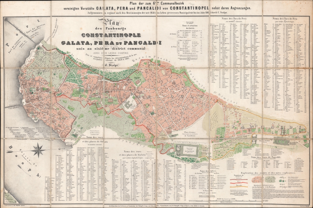

FOR THE ORIGINAL ANTIQUE MAP, WITH HISTORICAL ANALYSIS, CLICK HERE.
Digital Map Information
Geographicus maintains an archive of high-resolution rare map scans. We scan our maps at 300 DPI or higher, with newer images being 600 DPI, (either TIFF or JPEG, depending on when the scan was done) which is most cases in suitable for enlargement and printing.
Delivery
Once you purchase our digital scan service, you will receive a download link via email - usually within seconds. Digital orders are delivered as ZIP files, an industry standard file compression protocol that any computer should be able to unpack. Some of our files are very large, and can take some time to download. Most files are saved into your computer's 'Downloads' folder. All delivery is electronic. No physical product is shipped.
Credit and Scope of Use
You can use your digial image any way you want! Our digital images are unrestricted by copyright and can be used, modified, and published freely. The textual description that accompanies the original antique map is not included in the sale of digital images and remains protected by copyright. That said, we put significant care and effort into scanning and editing these maps, and we’d appreciate a credit when possible. Should you wish to credit us, please use the following credit line:
Courtesy of Geographicus Rare Antique Maps (http://www.geographicus.com).
How Large Can I Print?
In general, at 300 DPI, you should at least be able to double the size of the actual image, more so with our 600 DPI images. So, if the original was 10 x 12 inches, you can print at 20 x 24 inches, without quality loss. If your display requirements can accommodate some loss in image quality, you can make it even larger. That being said, no quality of scan will allow you to blow up at 10 x 12 inch map to wall size without significant quality loss. For more information, it is best consult a printer or reprographics specialist.
Refunds
If the high resolution image you ordered is unavailable, we will fully refund your purchase. Otherwise, digital images scans are a service, not a tangible product, and cannot be returned or refunded once the download link is used.
Julius Straube (April 12, 1832 - October 24, 1913) was a German cartographer. Born in Berlin and the son of a master butcher, Straube began training as a military cartographer at the age of 15. Straube founded the Geographische Institut und Landkartenverlag Julius Straub on July 3, 1858 and ran the business until 1886, when his son Benno took over. Between the Wilhemina era and the First World War, Straube's business was the market leader among Berlin cartographic institution's, garnering a 36% market share. In 1885, Straube published his most impressive work, a monumental 44-sheet Overview Plan of Berlin. Beginning in 1900, the Straube firm began to see more competition in the marketplace, and in 1913 Benno Straube had insolvency proceedings opened against him. Julius Straube died six days later. More by this mapmaker...
Copyright © 2025 Geographicus Rare Antique Maps | Geographicus Rare Antique Maps
This copy is copyright protected.
Copyright © 2025 Geographicus Rare Antique Maps