This item has been sold, but you can get on the Waitlist to be notified if another example becomes available, or purchase a digital scan.
1928 Regional Plan of New York City, Tri-State Region Parks, Parkways, and Highways
GeneralPlanNYCParks-regionalplan-1928$400.00

Title
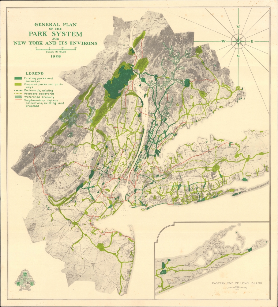
General Plan of the Park System for New York and Its Environs.
1928 (dated) 21 x 19 in (53.34 x 48.26 cm) 1 : 350000
1928 (dated) 21 x 19 in (53.34 x 48.26 cm) 1 : 350000
Description
An absorbing map of the existing and proposed park system of New York City and the Tri-State Area, produced in 1928 by the nonprofit organization Regional Plan of New York and Environs. Among other features, it highlights the popularity of parkways as a means of providing automobile passengers with a pleasant experience traveling to and from the city.
Perhaps the most intriguing aspect of this map is the promotion of parkways. Though today we might think of freeways and parkland as mutually exclusive, urban planning at the time envisaged forested scenic routes to carry automobile passengers in and out of New York City. Ideally, a suburban commuter could leave their home, nestled in the clean-aired countryside, and enjoy similarly bucolic views before reaching the hustle and bustle of the city. Though these early parkways later evolved into typical urban avenues or were expanded to accommodate more traffic at higher speeds, many retain the name 'parkway' and their original meandering routes (typically following rivers), as opposed to the mostly straight lines of modern highways. In some cases, such as the Merritt Parkway and portions of the Henry Hudson Parkway, gorgeous scenery can still be experienced as intended by the roads' designers.
As the 1920s drew to a close, years of research and discussion resulted in maps, publications, and other media being brought to the public. Although the Regional Plan was not associated with the legendary urban planner Robert Moses (1888 - 1981), their ideas were largely congruent, and the Regional Plan provided added momentum to the push for building highways (including parkways) in the city in a more deliberate and comprehensive manner. It is worth noting that although the 1930s saw a deep economic depression throughout the country, many infrastructure and urban planning projects were undertaken in New York City during these years, leaving the city with most of the bridges, tunnels, and highways that it maintains today.
A Closer Look
Coverage embraces the New York City metropolitan area, from the Hudson Valley in the north to Manasquan on the Jersey Shore in the south, and from Sussex and Warren County, New Jersey in the west to Bridgeport, Connecticut and the tip of Long Island in the east (presented in an inset at bottom-right). Existing parks are displayed in dark green, while proposed parks are illustrated in lighter green. Many of the proposed parks were eventually realized, the most substantial being the Ramapo Valley County Reservation and other lands around the already-extant Harriman State Park (the second largest in New York).Perhaps the most intriguing aspect of this map is the promotion of parkways. Though today we might think of freeways and parkland as mutually exclusive, urban planning at the time envisaged forested scenic routes to carry automobile passengers in and out of New York City. Ideally, a suburban commuter could leave their home, nestled in the clean-aired countryside, and enjoy similarly bucolic views before reaching the hustle and bustle of the city. Though these early parkways later evolved into typical urban avenues or were expanded to accommodate more traffic at higher speeds, many retain the name 'parkway' and their original meandering routes (typically following rivers), as opposed to the mostly straight lines of modern highways. In some cases, such as the Merritt Parkway and portions of the Henry Hudson Parkway, gorgeous scenery can still be experienced as intended by the roads' designers.
The First Regional Plan for New York
The impetus for the creation of the Regional Plan of New York was driven primarily by three factors: firstly, the greater affordability and mass adoption of automobiles in the 1920s; secondly, the explosive growth of New York City's population at the turn of the 20th century; and, thirdly, the contemporaneous Modernist affinity for ambitious urban planning. Inspired by similar plans for other cities, particularly the 1909 Burnham Plan for Chicago, a group of business and civic leaders led by banker Charles Dyer Norton formed an advisory committee in 1914 to propose an equivalent project for New York. Delayed by the First World War and other hurdles, the committee nevertheless made progress, adding prominent members (including future president Herbert Hoover) and forming a permanent body in 1922.As the 1920s drew to a close, years of research and discussion resulted in maps, publications, and other media being brought to the public. Although the Regional Plan was not associated with the legendary urban planner Robert Moses (1888 - 1981), their ideas were largely congruent, and the Regional Plan provided added momentum to the push for building highways (including parkways) in the city in a more deliberate and comprehensive manner. It is worth noting that although the 1930s saw a deep economic depression throughout the country, many infrastructure and urban planning projects were undertaken in New York City during these years, leaving the city with most of the bridges, tunnels, and highways that it maintains today.
Publication History and Census
This map was produced by the Regional Plan Association in 1928 to accompany its first report and comprehensive plan, published the following year. Although the report included many maps, the present map was one of four included in a pocket attached to the back cover, not always present in surviving examples of the report (the maps were also separately published as The graphic regional plan atlas and description in 1929). This map is independently cataloged among the holdings of Yale University, the University of Pennsylvania, the Joint Free Public Library in Morristown, New Jersey, and the University of Wisconsin Milwaukee.Cartographer
Regional Plan of New York and Environs (1922 - present), or Regional Plan Association (abbreviated as RPA), is a nonprofit advisory organization founded by urban planners and civic leaders to develop comprehensive plans for infrastructure, transportation, zoning, and other aspects of urban planning in the New York City metropolitan area. Publishing its first regional plan in 1929, three subsequent plans followed in the 1960s, 1990s, and 2010s. Although the organization's focus has changed somewhat as the city has (adding, for example, a focus on preparing for climate change in recent years), it has consistently advocated for more affordable housing, greenspace, playgrounds, and mass transit, to improve the lives of residents of the city and its surrounding region. Despite not being a government body, the organization has had an influence on multiple projects in the New York City area, including the George Washington Bridge and the revitalization of both neighborhoods and greenspace in the city. More by this mapmaker...
Source
Committee on Regional Plan of New York and Its Environs, Regional Plan of New York and Its Environs, (Philadelphia: Wm. F. Fell and Co.) 1929.
Condition
Very good. Light foxing.
References
OCLC 85852238.