1710 Homann Map of Southern Germany and Austria: War of Spanish Succession
GermaniaeAustriacae-homann-1710$450.00

Title
Leopoldi Magni Filio Iosepho I. Augusto Romanorum et Hung: Regi Ad capeßendum Rhenanae Militiae Imperium in Castra proficiscenti Hanc Germaniae Austriacae Generalem Tabulam...
1710 (undated) 20.5 x 23.5 in (52.07 x 59.69 cm) 1 : 1400000
1710 (undated) 20.5 x 23.5 in (52.07 x 59.69 cm) 1 : 1400000
Description
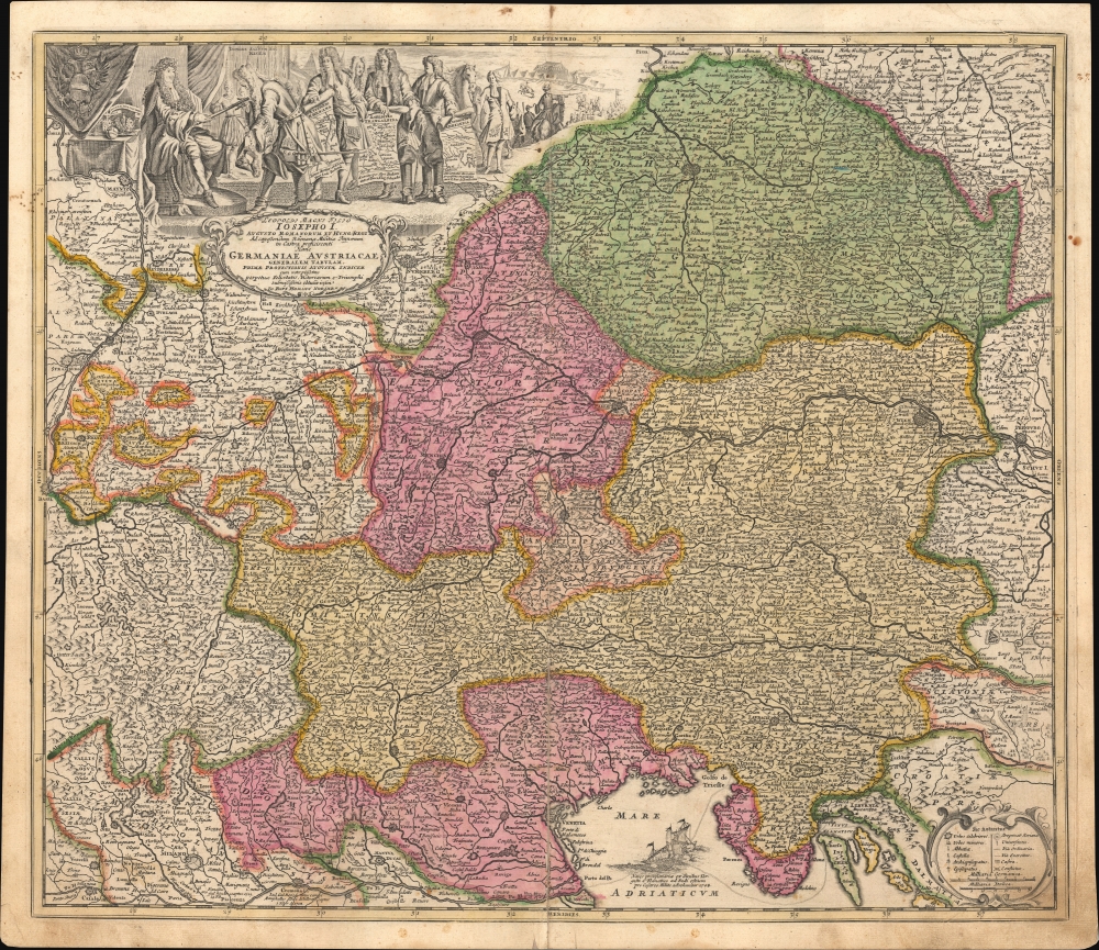
This is a c. 1710 Johann Baptist Homann map of southern Germany, Austria, and environs, produced for his Neuer Atlas. It is essentially wartime propaganda, celebrating the victories of the Habsburgs and their allies in the War of the Spanish Succession and supporting the Holy Roman Emperor Joseph I (r. 1705 - 1711).
Evidence of the ongoing War of the Spanish Succession (1701 - 1714, discussed below) is everywhere. The elaborate cartouche at the top presents the Habsburg Holy Roman Emperor Joseph I, to whom the map is dedicated, with a retinue of generals meant to represent the commanders of the Habsburg-led Grand Alliance, including Prince Eugene of Savoy and John Churchill, the English Duke of Marlborough (ancestor of Prime Minister Winston Churchill), two of the greatest military commanders of their time. The figure bowing to the emperor is likely Prince Eugene of Savoy. Behind him, generals hold maps of battlefields along the Rhine, in northern Italy, and in the Adriatic. (Text at the bottom of each identifies the commanders of the battles - the Duke of Baden, the Duke Eugene of Savoy, and so on - and it is possible that the figures are meant to represent the victor of each battle, meaning the third figure from Joseph would be Eugene of Savoy). The attendant and horse behind them are ready to carry Joseph to the battlefield in the distance, presumed to be the Siege of Landau (1702), when Joseph was still 'just' an archduke, the only military campaign in which he ever directly participated. In the Adriatic, there is a fleet, and an accompanying note explains that it delivered supplies to Grand Alliance forces in northern Italy. The legend at the bottom right includes a symbol denoting the location of battles. However, these appear to be earlier battles, such as the Sack of Brescia in 1512, rather than contemporary ones.
The war saw alliances shift, especially when Joseph I died in 1711 without an heir and was succeeded by Archduke Charles, presenting a new threat of a European superpower, this time a Habsburg one, emerging from the conflict. The result was that in the Peace of Utrecht, signed in 1713, Philip was granted the Spanish Crown but renounced any claim to the French throne, while Charles was maintained as the Holy Roman Emperor. Although this ostensibly was a raw deal for Charles, in reality, the Bourbon monarchies had been considerably weakened by the conflict, losing all their territory in Italy, as well as granting Gibraltar to the British, while the Habsburg side gained territory and strengthened its position in Hungary and the Netherlands. Britain is generally seen as the main beneficiary of the conflict, as, although it participated, it was not badly impacted by the mostly continental war. With the Dutch suffering both physical and financial costs, the door was open for Britain to become the main commercial maritime power in Europe and the world.
A Closer Look
Coverage embraces from Mainz, Heidelberg, Nurnberg (Homann's hometown), and Prague in the north to Milan, Venice, and Istria in the south, and from Strasburg and Basel in the west to Vienna and Bratislava (Pressburg) in the east. Color-shading indicates the region's various kingdoms, principalities, etc., including the Republic of Venice. Bavaria, prominent near the center, was initially aligned with Bourbon France against the Habsburgs but was forced to leave the conflict following a crushing defeat at the Battle of Blenheim in 1704. Various cities in southern Germany (here as Swabia / Svevia) appear as exclaves from the surrounding lands; at least some of these were besieged during the conflict, likely the source for their being so designated.Evidence of the ongoing War of the Spanish Succession (1701 - 1714, discussed below) is everywhere. The elaborate cartouche at the top presents the Habsburg Holy Roman Emperor Joseph I, to whom the map is dedicated, with a retinue of generals meant to represent the commanders of the Habsburg-led Grand Alliance, including Prince Eugene of Savoy and John Churchill, the English Duke of Marlborough (ancestor of Prime Minister Winston Churchill), two of the greatest military commanders of their time. The figure bowing to the emperor is likely Prince Eugene of Savoy. Behind him, generals hold maps of battlefields along the Rhine, in northern Italy, and in the Adriatic. (Text at the bottom of each identifies the commanders of the battles - the Duke of Baden, the Duke Eugene of Savoy, and so on - and it is possible that the figures are meant to represent the victor of each battle, meaning the third figure from Joseph would be Eugene of Savoy). The attendant and horse behind them are ready to carry Joseph to the battlefield in the distance, presumed to be the Siege of Landau (1702), when Joseph was still 'just' an archduke, the only military campaign in which he ever directly participated. In the Adriatic, there is a fleet, and an accompanying note explains that it delivered supplies to Grand Alliance forces in northern Italy. The legend at the bottom right includes a symbol denoting the location of battles. However, these appear to be earlier battles, such as the Sack of Brescia in 1512, rather than contemporary ones.
Generals or Emperor?
This map has a contentious relationship with a highly similar and even rarer contemporary work, Pieter Schenk's 'Invictissimis Heroibus Duci Marleborough, Principibus Eugenio Sabaudo, et Hassiae-Casselio…' While Homann's map is generally agreed to have been engraved in 1705, it is unclear if Schenk's map came before or after (most sources say after, in 1706). In any event, Schenk replaces Joseph with his father, Leopold I (who was likely already dead when the map was printed), and shifts the arrangement of figures in order to more clearly identify and glorify the generals of the Grand Alliance, and particularly the Duke of Marlborough. Other elements of the cartouche are changed or rearranged, and one of the maps is swapped with a map focusing specifically on the Battle of Blenheim. Schenk's motivations in doing so are unclear - perhaps he was trying to capitalize on the good fortunes of the Alliance to sell maps - but his apparent snub of Joseph I is suggestive of some other motive.The War of the Spanish Succession (1701 - 1714)
As its name indicates, the War of the Spanish Succession resulted when the childless Spanish Habsburg King Charles II died in 1700. Afterward, rival claimants aimed to ascend the throne, with the young Bourbon Philip of Anjou (grandson of Louis XIV) being proclaimed King of Spain on November 1, 1700. This presented a direct threat to the balance of power in Europe as Philip was also likely to eventually become king of France, thus raising the possibility of unifying Europe's two largest and most powerful Catholic kingdoms. As a result, the Habsburg Archduke Charles (younger brother of Joseph I), who also claimed the right to the Spanish Crown, gained considerable support from other European powers wary of a Franco-Spanish union. The Bourbon and Habsburg-aligned forces engaged in an epic conflict across much of western Europe and even the New World (as Queen Anne's War). As the subtitle here indicates, much of the fighting took place along the Rhine, especially in the Low Countries but also further south. At the same time, the Austrians were also bedeviled by a French-backed rebellion in Hungary (Rákóczi's War of Independence). In 1704, French and Bavarian armies even threatened Vienna but were decisively defeated at the Battle of Blenheim.The war saw alliances shift, especially when Joseph I died in 1711 without an heir and was succeeded by Archduke Charles, presenting a new threat of a European superpower, this time a Habsburg one, emerging from the conflict. The result was that in the Peace of Utrecht, signed in 1713, Philip was granted the Spanish Crown but renounced any claim to the French throne, while Charles was maintained as the Holy Roman Emperor. Although this ostensibly was a raw deal for Charles, in reality, the Bourbon monarchies had been considerably weakened by the conflict, losing all their territory in Italy, as well as granting Gibraltar to the British, while the Habsburg side gained territory and strengthened its position in Hungary and the Netherlands. Britain is generally seen as the main beneficiary of the conflict, as, although it participated, it was not badly impacted by the mostly continental war. With the Dutch suffering both physical and financial costs, the door was open for Britain to become the main commercial maritime power in Europe and the world.
Publication History and Census
This map was prepared by Johann Baptist Homann, originally c. 1705, though this example dates from the c. 1710 edition of his Neuer Atlas. In any event, the prominence of Joseph I indicates that the map must have been prepared during his reign, between 1705 and 1711. After Joseph's death, Homann published a highly-similar map under the title 'Germania Austriaca' (expertly examined in Chet Van Duzer's book Frames That Speak: Cartouches on Early Modern Maps). In this edition, reissued through the late 1710s and into the 1720s (see Rumsey 12499.109), not only is Joseph removed, but the cartouche is completely changed, and all references to the war on land and sea are removed. Also, as discussed above, Pieter Schenk appears to have copied Homann's map but changed the cartouche to celebrate the generals of the Grand Alliance rather than Joseph I. Both this edition of Homann's map and Schenck's iteration of it are scarce today, and the present map appears to be cataloged outside of Europe only at the University of Southern Maine.Cartographer
Johann Baptist Homann (March 20, 1664 - July 1, 1724) was the most prominent and prolific map publisher of the 18th century. Homann was born in Oberkammlach, a small town near Kammlach, Bavaria, Germany. As a young man, Homann studied in a Jesuit school and nursed ambitions of becoming a Dominican priest. Nonetheless, he converted to Protestantism in 1687, when he was 23. It is not clear where he mastered engraving, but we believe it may have been in Amsterdam. Homann's earliest work we have identified is about 1689, and already exhibits a high degree of mastery. Around 1691, Homann moved to Nuremberg and registered as a notary. By this time, he was already making maps, and very good ones at that. He produced a map of the environs of Nürnberg in 1691/92, which suggests he was already a master engraver. Around 1693, Homann briefly relocated to Vienna, where he lived and studied printing and copper plate engraving until 1695. Until 1702, he worked in Nuremberg in the map trade under Jacob von Sandrart (1630 - 1708) and then David Funck (1642 - 1709). Afterward, he returned to Nuremberg, where, in 1702, he founded the commercial publishing firm that would bear his name. In the next five years, Homann produced hundreds of maps and developed a distinctive style characterized by heavy, detailed engraving, elaborate allegorical cartouche work, and vivid hand color. Due to the lower cost of printing in Germany, the Homann firm could undercut the dominant French and Dutch publishing houses while matching their diversity and quality. Despite copious output, Homann did not release his first major atlas until the 33-map Neuer Atlas of 1707, followed by a 60-map edition of 1710. By 1715, Homann's rising star caught the attention of the Holy Roman Emperor Charles VI, who appointed him Imperial Cartographer. In the same year, he was also appointed a member of the Royal Academy of Sciences in Berlin. Homann's prestigious title came with several significant advantages, including access to the most up-to-date cartographic information as well as the 'Privilege'. The Privilege was a type of early copyright offered to very few by the Holy Roman Emperor. Though less sophisticated than modern copyright legislation, the Privilege offered limited protection for several years. Most all J. B. Homann maps printed between 1715 and 1730 bear the inscription 'Cum Priviligio' or some variation. Following Homann's death in 1724, the firm's map plates and management passed to his son, Johann Christoph Homann (1703 - 1730). J. C. Homann, perhaps realizing that he would not long survive his father, stipulated in his will that the company would be inherited by his two head managers, Johann Georg Ebersberger (1695 - 1760) and Johann Michael Franz (1700 - 1761), and that it would publish only under the name 'Homann Heirs'. This designation, in various forms (Homannsche Heirs, Heritiers de Homann, Lat Homannianos Herod, Homannschen Erben, etc.) appears on maps from about 1731 onwards. The firm continued to publish maps in ever-diminishing quantities until the death of its last owner, Christoph Franz Fembo (1781 - 1848). More by this mapmaker...
Source
Homann, J. B., Neuer Atlas bestehend in einig curieusen Astronomischen Kuppren und vielen auserlesenen accuratensten Land-Charten über die Gantze Welt, (Nuremberg: Homann) 1710.
Homann's Neuer Atlas bestehend in einig curieusen Astronomischen Kuppren und vielen auserlesenen accuratensten Land-Charten über die Gantze Welt was first publihsed in 1707 with 33 maps. A second edition followed in 1710 with 60 maps. Subsequent editions followed until about 1730. The title page notes proudly that the atlas features measurements based on the 'Copernican principle of the moving sky', a truly state-of-the-art innovation for the period. Regardless of editions, collations of the atlas are inconsistent, with some examples having less, while others have more maps - a consequence of the fact that the map sheets were delivered loose, to be bound at the buyer's discretion, and so some buyers chose to omit maps they did not consider relevant, or add others they did. Between editions, the constituent maps, particularly of European regions, were regularly updated to reflect the most recent political events. The atlas continued to be published by Homann's son, J. C. Homann (1703 - 1730), and then by Homann Heirs. Most examples also feature a fine allegorical frontispiece with the title Atlas Novus Terrarum Orbis Imperia, regna et Status, which was used for multiple Homann atlases, including the Neuer Atlas and the Atlas Minor.
Condition
Good. Closed centerfold split extending from bottom roughly 5 inches into page. Repaired and stabilized on verso. Laid down contemporaneous paper, likely by 18th century binder. Minor border soiling.
References
University of Southern Maine Osher Map Library Smith Collection Barcode: 4103. Van Duzer, C., Frames that Speak: Cartouches on Early Modern Maps, (Leiden: Brill) 2023, pp. 146-150.