This item has been sold, but you can get on the Waitlist to be notified if another example becomes available, or purchase a digital scan.
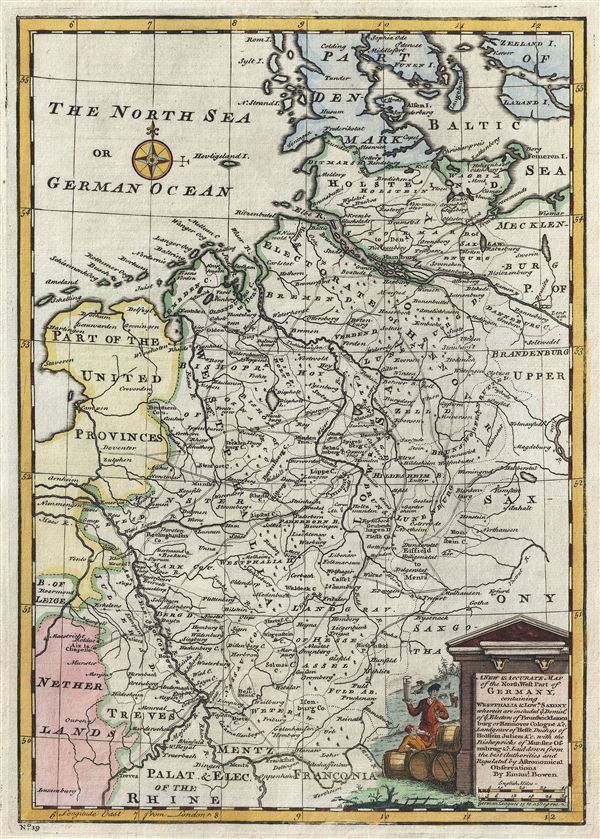
1747 Bowen Map of Northwestern Germany (Westphalia, Lower Saxony)
GermanyNW-bowen-1747$112.50

Title
A New and Accurate Map of the Northwest part of Germany, containing Westphalia and Lowr. Saxony, wherein are included ye. domins. of ye. Electors of Brunswick Lunenburg or Hannover Cologne etc., Landgrave of Hesse, Duchys of Holstein, Juliers etc., with the Bishopricks of Munster, Osnabrug etc.
1747 (undated) 13.5 x 9.5 in (34.29 x 24.13 cm) 1 : 2150000
1747 (undated) 13.5 x 9.5 in (34.29 x 24.13 cm) 1 : 2150000
Description
This is an appealing 1747 map of the northwestern part of Germany by the British Cartographer Emanuel Bowen. It covers the Westphalia and Lower Saxony regions of Germany from Denmark south as far as Mainz (Mentz) and Frankfurt and from the Netherlands east as far as Brandenburg. Several important cities, towns, rivers, roads, lakes and other topographic features are noted throughout with mountains beautifully rendered in profile.
Lower Saxony was one of the 'imperial circles' created by the Holy Roman empire in the 1500s. Groupings of regional territories were designed for defensive, tax, and administrative purposes within the empire. Westphalia, in 1648, became famous when the 'Peace of Westphalia' was signed in Munster and Osnabruck, ending the Thirty Years' War.
The map includes a beautifully illustrated title cartouche in the lower right quadrant. This map was prepared by Emanuel Bowen as plate no. 19 for the 1747 issue of A Complete System of Geography.
Cartographer
Emanuel Bowen (1694 - May 8, 1767) had the high distinction to be named Royal Mapmaker to both to King George II of England and Louis XV of France. Bowen was born in Talley, Carmarthen, Wales, to a distinguished but not noble family. He apprenticed to Charles Price, Merchant Taylor, from 1709. He was admitted to the Merchant Taylors Livery Company on October 3, 1716, but had been active in London from about 1714. A early as 1726 he was noted as one of the leading London engravers. Bowen is highly regarded for producing some of the largest, most detailed, most accurate and most attractive maps of his era. He is known to have worked with most British cartographic figures of the period including Herman Moll and John Owen. Among his multiple apprentices, the most notable were Thomas Kitchin, Thomas Jeffreys, and John Lodge. Another apprentice, John Oakman (1748 - 1793) who had an affair with and eventually married, Bowen's daughter. Other Bowen apprentices include Thomas Buss, John Pryer, Samuel Lyne, his son Thomas Bowen, and William Fowler. Despite achieving peer respect, renown, and royal patronage, Bowen, like many cartographers, died in poverty. Upon Emanuel Bowen's death, his cartographic work was taken over by his son, Thomas Bowen (1733 - 1790) who also died in poverty. More by this mapmaker...
Source
Bowen, E., A Complete System of Geography. Being a description of all the countries, islands, cities, chief towns, harbours, lakes, and rivers, mountains, mines, etc., of the known world …, (London) 1747.
Condition
Very good. Blank on verso. Original platemark visible.
References
Rumsey 3733.018. Philips (atlases) 614 (1752 edition).