This item has been sold, but you can get on the Waitlist to be notified if another example becomes available, or purchase a digital scan.
1943 Mooney Map or Plan of Golden Gate Park, San Francisco
GoldenGatePark-mooney-1943$125.00

Title
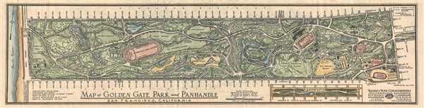
Map of Golden Gate Park and Panhandle, San Francisco, California
1943 (dated) 5 x 20.5 in (12.7 x 52.07 cm) 1 : 9600
1943 (dated) 5 x 20.5 in (12.7 x 52.07 cm) 1 : 9600
Description
This is a 1943 Hugh Mooney map of Golden Gate Park in San Francisco, California. The map depicts the park from Stanyan Street to the Pacific Ocean and from Fulton Street to Lincoln Way. Beautifully hand colored, Golden Gate Park is presented in detail with location throughout the park labeled. The children's playground, tennis courts, arboretum, aquarium, and museum are all noted, along with each of the roads running through the park. All the cross streets are also labeled around the perimeter of the park. Statistics concerning the area of the park and certain distances are included in the bottom left corner. An inset of Panhandle Park is situated along the bottom border. Panhandle Park is depicted from Stanyan Street to Baker Street and from Fell Street to Oak Street.
This map was drawn by Hugh Mooney and published by the Board of Park Commissioners of San Francisco, California in 1943.
This map was drawn by Hugh Mooney and published by the Board of Park Commissioners of San Francisco, California in 1943.
Condition
Very good. Text on verso.