1945 Neutze / Arimany Pictorial Map of Guatemala
GuatemalaPictorial-neutze-1945$350.00

Title
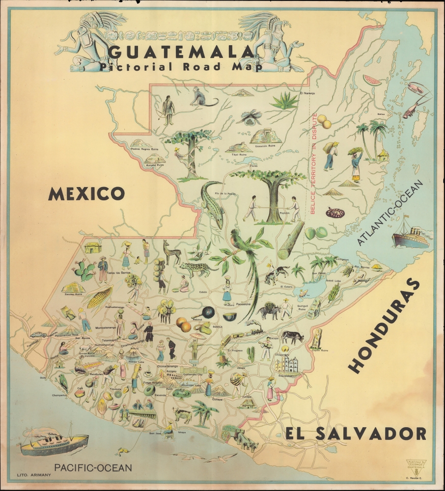
Guatemala Pictorial Road Map.
1945 (undated) 21 x 23.5 in (53.34 x 59.69 cm) 1 : 1215000
1945 (undated) 21 x 23.5 in (53.34 x 59.69 cm) 1 : 1215000
Description
A c. 1945 pictorial map of Guatemala, drawn by C. Neutze and printed by Litografía Arimany.
A Closer Look
Presenting the entire country, including the disputed territory of Belize, the map includes colorful illustrations depicting the history, culture, economy, flora, and fauna. True to the title, roads are displayed throughout, along with railways, major cities, topographic features, and Mayan ruins. The text above the title at the top is a series of Mayan glyphs.Belize Territorial Dispute
The inclusion of the disputed territory of Belize (British Honduras) reflects mid-19th century Guatemalan claims to the territory as one of its own departamentos. An 1859 treaty seemingly settled the issue, but the deal was contingent upon Britain building a road from the Caribbean to Guatemala, which failed to materialize after difficult negotiations. The issue became contentious again in the 1930s and remained so for much of the 20th century, with Guatemala occasionally threatening invasion. In recent years, the dispute has continued through mediation and is currently before the International Court of Justice.United Fruit Company
Around the time this map was published, U.S. companies, especially the United Fruit Company, played a dominant role in the Guatemalan economy. The country's rail infrastructure, most notably the line to Puerto Barrios, was built with the export of agricultural goods in mind and, in the early 20th century, came under United Fruit ownership (via its subsidiary, the International Railways of Central America). The company also managed the country's postal service, paid no taxes, and was the largest landholder in Guatemala.The Pan-American Highway
Labeled here as the Panamerican Road, the Pan-American Highway is a network of roads measuring about 29,800 miles in length that links the mainland nations of the Americas via a single interconnected highway system stretching from Alaska to Buenos Aires, Argentina and Santiago, Chile, except for a 54-mile break at the Darien Gap on the border of Panama and Colombia. By improving existing highways and constructing new ones, the long-discussed project was gradually brought to fruition over several decades in the early-mid 20th century, with periodic advances when efforts could be organized at an international level. One such period was the presidency of Franklin D. Roosevelt, who advocated extending the road south from Mexico, which it already traversed by the mid-1940s. Roosevelt's support for the highway's construction through Latin America was a manifestation of his Good Neighbor Policy.Publication History and Census
This map was drawn by C. Neutze (about whom no further information is available), printed by Litografía Arimany, and published by 'Cosmos' Guatemala. It is undated, but both stylistically and from context can be dated to c. 1945. The map is quite rare; it is not recorded in any institutional collections in the OCLC and has only appeared on the market once in recent years.Cartographer
Litografía Arimany (fl. c. 1935 - 1955) was a lithographic printing house active in Guatemala, alternatively using the names Imprenta Arimany and José Arimany e Hijos, Litografía. The company had a close relationship with the country's government, especially the Oficina Nacional de Turismo, producing travel guides, maps, and promotional materials in English and Spanish. More by this mapmaker...
Condition
Good. Light soiling. Minor discoloration at bottom. Some loss at top edge.