This item has been sold, but you can get on the Waitlist to be notified if another example becomes available, or purchase a digital scan.
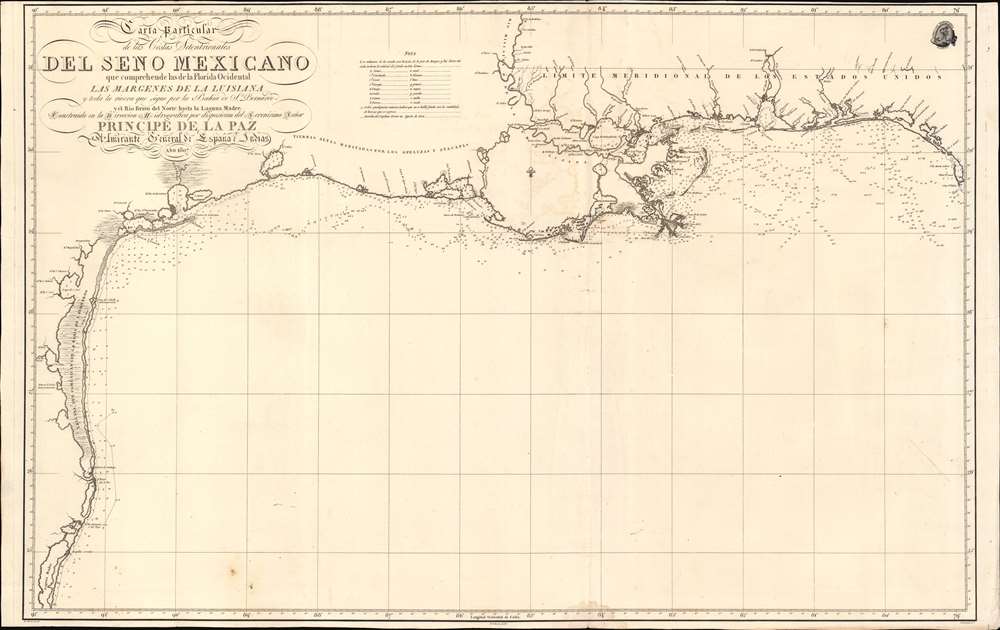
1807 Direccion Hidrografica Map of the Gulf Coast: Texas, Mexico, Louisiana
GulfCoastTexas-direccionhidrografica-1807
Title
1807 (dated) 23.25 x 37 in (59.055 x 93.98 cm) 1 : 1500000
Description
A Closer Look
Roughly centered on modern day Vermillion Bay, coverage extends along the Gulf Coast from Laguna Madre, Mexico (just south of the border) to Cape San Blas, Florida. The chart offers a wealth of detailed soundings precisely following Evia's tracks. Of note are some of the river systems and inlets, which although treated minimally offer more accuracy than any previous chart. In particular, note the precise mapping of the Mississippi Delta and the complex network of bays, lakes, bayous, and rivers between Vermillion Bay and Mobile Bay, and inland as far as Natchez.Jose Antonio de Evia Survey of the Gulf Coast
From 1763, when the British seized Florida during the Seven Years War (1856 - 1863), until 1783, Spanish and British navigators vied for control of the Gulf of Mexico. The tension led to a dearth of good nautical survey work. The best available preceding maps were those published in Jeffery's West India Atlas, 1775, which Streeter described as 'an almost meaningless jumble' (Streeter 1029). After Britain lost the American Revolutionary War (1775 - 1783), Florida was retroceded to Spain, granting Spanish navigators unimpeded access to the coast. Consequently, in 1783, Bernardo de Gálvez (1746 - 1786), the newly assigned interim governor of Spanish Louisiana, commanded Jose Antonio de Evia (Josef de Hevia; 1740 - c. 1798) to explore the Gulf Coast from West Florida to Tampico. After a failed 1783 attempt, the expedition proceeded, and from 1785 to 1786 the coasts of Florida, Alabama, Mississippi, Louisiana, Texas, and Mexico were scientifically mapped for the first time. Evia also successfully explored, via lugger and canoe, rivers and inlets along the coast - an exceptionally arduous task performed under harsh conditions. Among his achievements, he explored San Bernardo Bay, naming it Galveston (Gálves-Town) to honor Gálvez. Evia's accurate and detailed charts, diaries, and descriptions of the Gulf area were the finest produced in the eighteenth century. His surveys served as the underpinning of Gulf Coast hydrography for decades, until superseded by the mid-19th century work of the U.S. Coast Survey. Two charts in specific were seminally important, the 1799 Carta Esferica que Comprehende las Costas del Seno Mexicano and this map, the more detailed 1807 Carta Particular de las Costas Septentrionales del Seno Mexicano. Despite an interval of 8 years, no intermediary charts were issued - possibly to keep the strategically valuable results of the Evia Survey under wraps.Publication History and Census
The preset example is the 1807 first edition of this important chart, published in Madrid by the Direccion Hidrografica. The chart was compiled by Miguel Moreno (fl. c. 1792 - 1845) and engraved by Ferdinand Selma (1752 - 1810) - who also engraved the Carta Esferica que Comprehende las Costas del Seno Mexicano. It was subsequently slavishly copied in the 1820s by the French Dépôt des Cartes et Plans de la Marine and the British Admiralty. A second edition, without significant revision, was issued in Mexico in 1825 - testimony to the map's accuracy and longevity. Derivative maps by both the Direccion Hidrografica and other foreign hydrographic agencies appear from time to time, but the first edition, as here, is exceedingly rare and can be considered one of the most important maps of Texas to appear in the 19th century. Rare. We note examples at Baylor University, the Biblioteca Nacional de España, the Museu Marítim de Barcelona, and the Bayerische Staatsbibliothek. There is possibly a fourth example at the Virginia Garrett Cartographic History Library at the University of Texas Arlington.CartographerS
The Direccion Hidrografía (1787 - 1927), also known as the Deposito Hydrografico and the Direction de Hidrografía, was the Spanish equivalent of the British Admiralty or the U.S. Coast Survey. This organization, founded in 1787, was commissioned to collect and produce accurate nautical charts of all waters frequented by Spanish vessels. In essence, it replaced the Casa de la Contratación de las Indias (House of Trade of the Indies), which closed its doors in 1790. Like most such organizations, the Direccion Hidrografía marked a new age in cartography. Rather than simply collect charts created by navigators, explorers, and merchants, the Direccion Hidrografía worked closely with naval and military personnel to mount cartographic and hydrographic expeditions in pursuit of the most accurate hydrographical, astronomical, and geodetic measurements. The Direccion Hidrografía created a massive library of nautical charts that, though not nearly as common as similar nautical charts by the U.S. Coast Survey and British Admiralty, are highly desirable for the beauty of their manufacture as well as their accuracy and detail. The office was originally located on Calle Ballesta, but relocated to 36 Alcala, both in Madrid. After 1908 the Dirección was subsumed into other governmental agencies. In 1927 the Direccion was absorbed into the Institute and Observatory of San Fernando, located in Cadiz. The library of original maps, charts, and journals was transferred to the Naval Museum of Madrid - where it resides to this day. More by this mapmaker...
Miguel Moreno (fl. c. 1792 - 1845) was a Spanish cartographer and draftsman active with the Depósito Hidrográfico in Madrid during the first half of the 19th century. Hs served in the Spanish royal navy as a pilot as early as 1808. By 1807 he was producing nautical charts for the Depósito Hidrográfico. He participated in the geographical expedition to South America of Cosme Damián Churruca (1792 - 95), which included the Antilles. Moreno was widely considered the Depósito Hidrográfico's primary expert on the Gulf Coast and Puerto Rico. Learn More...
Ferdinand Selma (1752 - January 8, 1810) was a Spanish line engraver active in Madrid with the Direccion Hidrografía in the late 18th and early 19th centuries. Selma was born in Valencia and died in Madrid. His is best known for his engravings for his 1788 Illustrations de Relacion del ultimo viage al estracho de Magallanes. Learn More...


