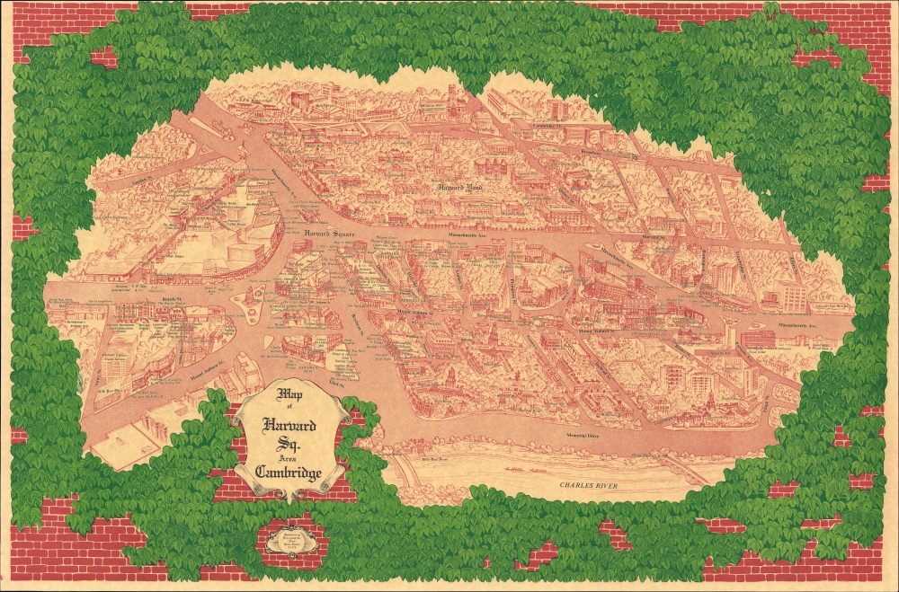
This is Blaise Domino's large-format 1978 pictorial bird's-eye view of Harvard Square and environs in Cambridge, Massachusetts, including Harvard Yard and much of the campus of Harvard University.
A Closer Look
Oriented roughly towards the northeast so that the Charles River forms a straight line at bottom, this view looks out over Harvard Square and the nearby portions of Cambridge as well as Harvard Yard and some adjacent parts of the wider Harvard campus. The view provides a fascinating glimpse into the historical roots and continual evolution of Harvard Square. While many of the university buildings seen here were already quite old and still stand today, others have since been renovated (a recent example is the Fogg Art Museum, now combined with two other collections and redubbed Harvard Art Museums).
Several of the structures seen here were relatively recent, having been constructed in the preceding decade. The Modernist-style Science Center (1973), seen at top, was a major and controversial project that led to Cambridge St. being depressed into an underpass and the reworking of the entire surrounding area. Built at the same time and just as controversial is the nearby George Gund Hall, completed in 1972, home to the Graduate School of Design. Like the Science Center, the building's design contrasted sharply with the older brick buildings on campus. The consideration and construction of both projects also coincided with the peak of the student movement in the United States in the late 1960s and early 1970s, including violent protests and police actions on the Yard in 1969 and 1970. The most recent university building seen here, though, is the dormitory Canaday Hall, in the vicinity of the Science Center and Gund Hall, though with a much less provocative design. Canaday Hall replaced Hunt Hall, the most recent building on the Yard to be torn down, in 1973. The Harvard Kennedy School of Government is seen here at its original location at the Littauer Center, which is still used by the school, but it has mostly relocated to a larger and newer campus located in the foreground, roughly where the title cartouche appears.
The surrounding area has seen equally dramatic changes. In 1981, not long after this view's publication, Boylston St. was renamed John F. Kennedy St. to honor the slain president and Massachusetts native. Though most businesses seen here have closed, some would be familiar to a modern-day resident of Cambridge, including Cardullo's, the Brattle Theater, Charlie's Kitchen, the Harvard Coop, and the Harvard Bookstore (unlike the Coop, not directly affiliated with the university despite its name). Out of Town News (here as Out of Town Newspapers and Ticket Agency), which likely saw more foot traffic than any other business in the area and, true to its name, was a unique source of foreign and foreign-language newspapers and magazines, closed in 2019. The area continues to evolve today; just this month (March 2025), work began to replace 'the Pit,' a public space constructed in 1982 at the intersection of Massachusetts Ave. and Boylston St. (J.F.K. St.) near the entrance to the MBTA station and Out of Town News.Publication History and Census
This view was prepared by artist Blaise Domino and published by the Pict-o-graph Co. (founded by Michael Shemin - refer to our cartographer biography of him). It is quite rare, only being noted in institutional collections at the Boston Public Library and as part of the David Rumsey Historical Map Collection. Both the BPL and Rumsey examples are dated 1976 and differ somewhat stylistically from the present edition.
Cartographer
Blaise J. Domino (1941 - present) is a Hawaii-based artist known for producing stylized historical pictorial maps of Hawaii and other locations. Domino moved to Hawaii in his youth with his family as his father served in the U.S. military. He began to produce art and win art competitions, while honing his skills at the University of Hawaii and other universities, including the Sorbonne in Paris. He ultimately returned to Hawaii and began producing the aforementioned maps under his own name as well as commercial art and maps for the likes of Delta Airlines, Western Airlines, and for local and state governments in Hawaii. More by this mapmaker...
Very good. Closed tear extending .25 inch into printed area from left margin professionally repaired on verso.
Rumsey 10829.000. OCLC 1336941140.