This item has been sold, but you can get on the Waitlist to be notified if another example becomes available, or purchase a digital scan.
1875 Pitschner Map of the Night Sky in Central Europe
Himmelskarte-pitschner-1875$475.00

Title
Himmelskarte.
1875 (undated) 41.25 x 41.5 in (104.775 x 105.41 cm)
1875 (undated) 41.25 x 41.5 in (104.775 x 105.41 cm)
Description
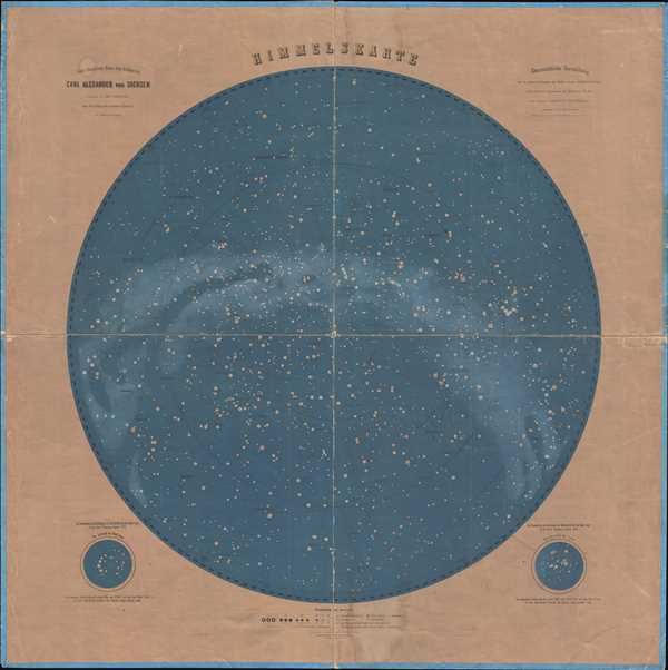
This is an 1875 Dr. Wilhelm Pitschner celestial map of the night sky over central Europe as seen from the summit of Mont Blanc. Highly detailed, numerous constellations, stars, and other celestial bodies are illustrated, including Andromeda and Cassiopeia. The Milky Way inscribes an arc across the sphere, adding a more ethereal aura to the piece. Two inset maps, illustrating the constellations Lyra and the Northern Crown are situated below the map to the right and left, respectively. A key, explaining the various different notations employed by Pitschner, is included below the map. The Grand Duke Carl Alexander of Saxony is said to be 'in awe of this presentation of the starry heavens.'
This map was produced by Dr. Wilhelm Pitschner and his colleagues in 1875 and printed in Munich.
This map was produced by Dr. Wilhelm Pitschner and his colleagues in 1875 and printed in Munich.
Cartographer
Dr. Wilhelm Pitschner was a Prussian scientist and astronomer alive during the mid-19th century. He led and expedition to the summit of Mont Blanc in the Alps where he and his team spent four weeks on the summit taking astronomical measurements, surveying, and making other observations. More by this mapmaker...
Condition
Good. Backed on linen. Light soiling. Wear along margins and original fold lines. Blank on verso.
References
OCLC 254050293.