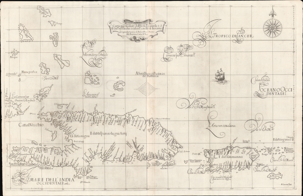
1647 Dudley Nautical Map of Hispaniola, Puerto Rico, and the Virgin Islands, West Indies
HispaniolaPuertoRico-dudley-1647$5,500.00


Title
Carta particolare dell'Isola Ispaniola è S. Gioni. nel'India ocidentle. con l'Isola Intorno.
1647 (undated) 20 x 31 in (50.8 x 78.74 cm) 1 : 1900000
1647 (undated) 20 x 31 in (50.8 x 78.74 cm) 1 : 1900000
Description
This is the first edition of Sir Robert Dudley's rare 1647 nautical map of the eastern Greater Antilles, including Hispaniola, Puerto Rico, the Virgin Islands, Turks and Caicos, St. Croix, and the southern Bahamas. Like most Caribbean maps from Dudley's Arcano del Mare, this represents the first usable printed nautical chart of Hispaniola and Puerto Rico.
A Closer Look
Presented on a Mercator Projection, coverage extends from eastern Cuba to Virgin Gorda and Anegada Island and from Guanahani (the indigenous Lucayan name for the Bahamian island of San Salvador) to St. Croix. A host of early settlements are noted, particularly on Hispaniola, with depth soundings and safe anchorages presented where available. The whole is stunningly engraved in Antonio Francesco Lucini's masterful Italian baroque hand, complete with fine calligraphy and idiosyncratic styling.Publication History and Census
This map was completed by Sir Robert Dudley in manuscript form c. 1636. It was then engraved in 1646-47 by Antonio Francesco Lucini for publication in 1647 in volume II of the first edition of Robert Dudley's seminal sea atlas, the Arcano del Mare. This is the first edition of the map issued for the 1647 atlas. A second edition of the atlas, also with this map, was issued in 1661. The maps from this edition are distinguished with additional numerical coding located below the title on the individual maps. We see a few examples in the OCLC, most associated with the more common 1661 edition, almost all associated with institutional holdings of the full atlas. We note a few examples of this map, in any edition, on the market in recent times.CartographerS
Sir Robert Dudley (August 7, 1573 - September 6, 1649) was an English explorer and cartographer, the publisher of the Dell’Arcano de Mare, one of the greatest nautical atlases of all time. He was the illegitimate son of Robert Dudley, 1st Earl of Leicester (a favorite of Queen Elizabeth I) and Douglas Sheffield, the widow of John Sheffield, 2nd Baron Sheffield. In 1594, Dudley led an expedition across the Atlantic, with the intent of harassing Spanish merchantmen. His expedition met with a series of misfortunes, but successfully returned to England the following year. In 1596, Dudley joined an expedition led by Robert Devereux, 2nd Earl of Essex, against Cadiz. He served as the commander of the Nonpareil, and was knighted for his conduct in the capture of Cadiz. In 1603, Dudley made an attempt to establish his legitimacy at court and gain several inheritances, after being (possibly erroneously) informed that his parents had been secretly married. No concrete proof of the marriage could be furnished, thus the judgement was handed down against him in May 1605. Dudley left England in July of the same year, with his lover and cousin Elizabeth Southwell, who was disguised as his page. They married in Lyon in 1606 having received a papal dispensation. The couple settled in Florence, where Dudley began using his father’s title, Earl of Leicester, and his uncle’s, Earl of Warwick. In Florence, Dudley designed and built warships for the arsenal at Livorno and became a naval advisor to Ferdinand I, Grand Duke of Tuscany. In 1607, James I revoked Dudley’s travel license once ordered that he return to provide for his deserted wife and family. Dudley refused, was subsequently labeled an outlaw, and his estate was confiscated. By far Dudley’s most important work was the Dell’Arcano del Mare (Secrets of the Sea). His most celebrated achievement, is the atlas of sea charts of the world which accompanied the work. This maritime atlas was the first nautical atlas of the entire world in print, the first made by an Englishman, the first to show prevailing winds and currents, and the first to use the Mercator projection throughout. More by this mapmaker...
Antonio Francesco Lucini (January 1, 1610 - 1661), a.k.a. Anton, was an Italian engraver and printmaker. Lucini was born in Florence born in 1605. Lucini initially studied engraving with Stefano della Bella (1610 - 1664) under Jacques Callot (c 1592 - 1635), who lived in Florence from 1612 to 1621. He is recorded in 1616 as Callot's assistant in Florence. After 1621, he joined flowed Callot in Nancy to continue his training. He returned to Florence sometime before 1631, when he published a series of plates on the Great Siege of Malta. He is best known in cartographic circles as the engraver for Sir Robert Dudley's seminal maritime atlas Dell'Arcano del Mare (Of the Mysteries of the Sea), published in Florence in 1645 - 1646. The 200 engraved plates and 146 charts which Lucini produced for Dudley occupied 12 years occupied 12 years of his life and consumed some 5000lbs of copper. The engravings exhibit Lucini’s masterful craftsmanship and are outstanding examples of Italian Baroque engraving. Indeed, while Dudley was a master chartmaker, it is Lucini's virtuoso engraving and fine calligraphy that most define Dudley's work. Learn More...
Source
Dudley, R., Dell'Arcano del Mare, (Florence: Francesco Onofri) 1647.
Dell’Arcano del Mare (Secrets of the Sea) is a six volume 17th century maritime encyclopedia by English nobleman Sir Robert Dudley (1573 - 1649). It is considered to be one of the most important maritime atlases of all time, the first of its kind in print: the first sea atlas to treat the entire world (not just Europe), the first by an Englishman, the first to illustrate prevailing winds and currents, and the first to universally employ a Mercator projection. The charts themselves are notable for being all new works, created by Dudley based upon a lifetime of collecting maritime data. All of the roughly 130 known charts in the Dell’Arcano del Mare were engraved in the Italian baroque aethetic by Antonio Francesco Lucini, a Florentine master engraver. It is said that the work took Lucini 12 years and consumed more than 5000lbs of copper. It was published in Florence between 1645 and 1646 in six folio volumes. Another edition was issued in 1661 but contained fewer charts.
Condition
Very good. Minor wormholes along centerfold filled on verso. Centerfold wear.
References
Boston Public Library, Leventhal, G1059 .D84 1647. Shirley, R., Maps in the atlases of the British Library, R., M.Dud-1a, 119. OCLC 1142907073 (1661), 1098216902 (1647).