This item has been sold, but you can get on the Waitlist to be notified if another example becomes available, or purchase a digital scan.
1747 Bowen Map of the Netherlands (Holland) and the North Sea
Holland-bowen-1747$100.00

Title
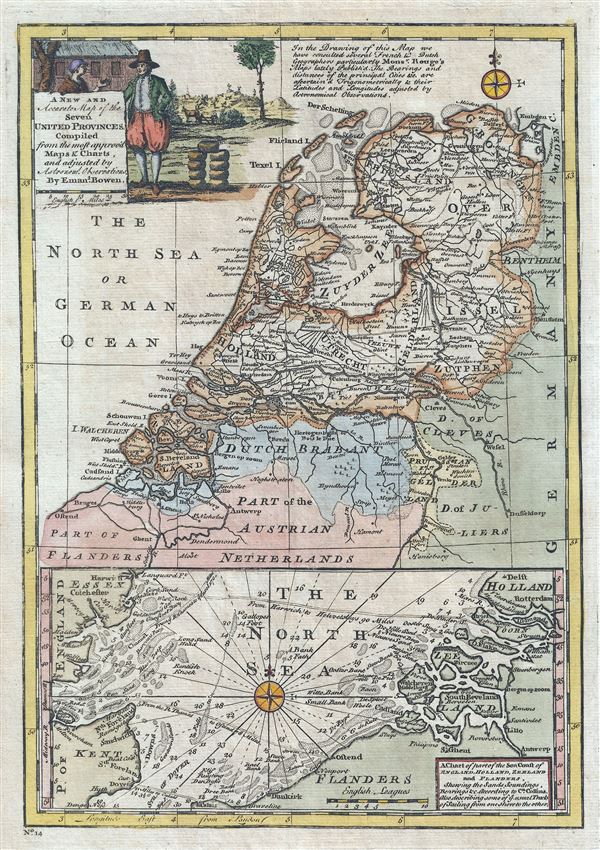
A New and Accurate Map of the Seven United Province. A Chart of part of the Sea Coast of England, Holland, Zeeland and Flanders, shewing the Sandy Soundings, Bearings etc.
1747 (undated) 13 x 9 in (33.02 x 22.86 cm) 1 : 1550000
1747 (undated) 13 x 9 in (33.02 x 22.86 cm) 1 : 1550000
Description
This is a beautiful 1747 map of Holland or the Netherlands by the British cartographer Emanuel Bowen. Essentially two maps on a single sheet, the top map depicts all of modern day Netherlands along with the northern parts of Belgium. Several towns, cities, rivers, lakes, roads and a host of additional topographical features are noted throughout, with mountains beautifully rendered in profile. The bottom map depicts the North Sea with the eastern coast of England and the western coast of Belgium and the Netherlands.
The region at the time this map was made was known as the 'Republic of the Seven United Provinces.' Officially recognized in the Peace of Westphalia in 1648, the Republic of the United Provinces lasted until 1794, when Napoleonic forces invaded and set up a new French client state, the Batavian Republic. After Napoleon's fall in 1815, the Congress of Vienna united these provinces with the Low Countries to the south to form the United Kingdom of the Netherlands. The Netherlands, with the world's first stock exchange, is considered to be the birthplace of the modern capitalist economy.
The lower map features a nautical chart of the eastern coast of England and the western coast of the Netherlands and Belgium. This chart notes coastal cities, shoals and islands. Rhumb lines and soundings are present throughout.
A beautiful title cartouche adorns the top left quadrant of the map, illustrating a scene with a man and woman in traditional outfits. This map was prepares by Emanuel Bowen as plate no. 14 for the 1747 issue of A Complete System of Geography.
Cartographer
Emanuel Bowen (1694 - May 8, 1767) had the high distinction to be named Royal Mapmaker to both to King George II of England and Louis XV of France. Bowen was born in Talley, Carmarthen, Wales, to a distinguished but not noble family. He apprenticed to Charles Price, Merchant Taylor, from 1709. He was admitted to the Merchant Taylors Livery Company on October 3, 1716, but had been active in London from about 1714. A early as 1726 he was noted as one of the leading London engravers. Bowen is highly regarded for producing some of the largest, most detailed, most accurate and most attractive maps of his era. He is known to have worked with most British cartographic figures of the period including Herman Moll and John Owen. Among his multiple apprentices, the most notable were Thomas Kitchin, Thomas Jeffreys, and John Lodge. Another apprentice, John Oakman (1748 - 1793) who had an affair with and eventually married, Bowen's daughter. Other Bowen apprentices include Thomas Buss, John Pryer, Samuel Lyne, his son Thomas Bowen, and William Fowler. Despite achieving peer respect, renown, and royal patronage, Bowen, like many cartographers, died in poverty. Upon Emanuel Bowen's death, his cartographic work was taken over by his son, Thomas Bowen (1733 - 1790) who also died in poverty. More by this mapmaker...
Source
Bowen, E., A Complete System of Geography. Being a description of all the countries, islands, cities, chief towns, harbours, lakes, and rivers, mountains, mines, etc., of the known world …, (London) 1747.
Condition
Very good. Original platemark visible. Blank on verso.
References
Rumsey 3733.013. Philips (atlases) 614 (1752 edition)